In 1947 and 1948, when the boundaries of the Jewish and Arab states were being debated by diplomats, David Ben-Gurion made it clear the Negev must be part of the Jewish state.
Though it was virtually uninhabited and thought by many to be uncultivable, Ben-Gurion knew this region was needed if the state was to grow. He also had faith that the desert could be tamed and turned into a place where Jews could settle and prosper.
Many decades later, his vision has been realized. Still, the desert remains untamed.
This is the wilderness where man met God. Here Abraham communed with God, and, centuries later, the prophet Elijah came to the Mountain of God for a momentous encounter with the Creator.
This, in fact, is the region that gave birth to civilization on the banks of the great rivers that surround the desert, and in the oases on the fringes of the wilderness. The desert trails of the Negev were the conduits for knowledge, culture and development.
Beersheba was first settled during the Chalcolithic period. The inhabitants lived in caves and worked in raising cattle and the manufacturing of metal tools. At the beginning of 2000 BCE, Abraham and Isaac arrived in Beersheba. There they dug wells and also formed alliances with Abimelech, the King of the Philistines. During King David’s reign, the Israelites conquered Beersheba, which became a city of the tribe of Simeon and was later incorporated into the tribe of Judah (Josh. 15:28; 19:2). The city became the capital of the “Negev Yehuda." Following the Israelites defeat from the conquering Babylonians, the city was deserted for many years. However, after the Jews return from Babylon it was resettled (Neh. 11:27, 30). During the Roman-Byzantine period, after 70 CE, Beersheba became apart of the frontier -line defenses against attacks by the Nabateans. The town was abandoned in the Arab period.
Modern History
The city was redeveloped by the Turks in 1900. Jewish settlement also began to return to the city during this time. On October 31, 1917, Beersheba was the first place in Israel captured by the British in World War I. During the British mandatory period, the city continued to develop and grow in size. During the 1936-39 Arab riots, most of the Jews left the city, but strong efforts were made in the 1940s to purchase land for Jewish settlement in the Negev. Following the declaration of independence of the State of Israel, the invading Egyptian army made Beersheba its headquarters. On October 21, 1948, the Israeli forces took the city in "Operation Moshe"; upon the Israeli conquest, the city was totally abandoned by its citizens. Following the war, Jewish settlers, mostly new immigrants, began to establish themselves there.
The Negev is still virtually unknown to most travelers. Its hidden canyons, vast expanses, clear blue skies, and stark promontories are still off the beaten track and provide a worthy challenge to those seeking adventure and thrills.
Sde Boker
When Ben-Gurion spoke of the future of the Negev, he was not doing so for mere rhetorical flourish. He believed what he said and made his home there, joining Kibbutz Sde Boker in 1953. Today, the hut where he lived is a small museum devoted to Ben-Gurion's legacy.
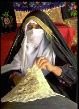
The gateway to the Negev is a place that once was little more than a watering hole for Abraham’s sheep. Today, Beersheba is a modern city of 130,000 and home to the Ben-Gurion University. It is also a place where you can still buy sheep and camels at the Bedouin market (open Thursdays 6 a.m.-1 p.m.). Roughly 27,000 Bedouin still live their nomadic lifestyle in the Negev.
The Bedouin
The name Beersheba comes from “The Well of the Oath” that Abraham made to Abimelech (Gen. 21:27 and 31). A stone-enclosed well said to be the one used by Abraham is at the corner of Derekh Hebron and Rehov Keren. Isaac and Jacob also lived in this area, which later was given to the Tribe of Simeon.
Though the city has remnants from the Roman and Byzantine periods, it was really little more than a collection of wells where Bedouin watered their flocks until the early 20th century when the Turks built a small town. The city was held by the Egyptians at the time of Israel's War of Independence, and was conquered in "Operation Ten Plagues" on October 21, 1948.
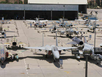
Just outside Beersheba is Hatzerim, the first air base built by Israel. Today, it serves the Israeli Air Force and hosts the pilot school. Next door is the Air Force Museum, one of the coolest museums for anyone interested in airplanes, helicopters and Israeli history. In addition to a gallery with displays of missiles and rockets and information on Israel's elite rescue squad and survival tactics, there is hall showing films and a huge outdoor exhibition area with examples of aircraft from the Israeli Air Force as well as some of its enemies. Some of the highlights include U.S.-made phantom jets, Soviet MiGs, the Israeli Lavie and the “Bar Mitzvah Twins,” two aircraft whose pilots each shot down 13 enemy aircraft in combat. While visiting you’ll likely hear the roar of engines from the base next door and may even catch a glimpse in the sky of one of the Air Force’s state-of-the-art fighter planes.
Israel Fact
The ancient city of Beersheba was designated a UNESCO World Heritage Site in 2005.
The ancient city of Beersheba was designated a UNESCO World Heritage site in 2005.