The E1 (East-1) building plan, located between Jerusalem and Ma’ale Adumim, has long been a flashpoint of tension—drawing fierce Palestinian opposition and criticism from the United States and other nations. Proposed decades ago, the project was never implemented. However, the project was given new life in 2025 when the government approved the construction of new homes in the area.
The Essential Points
Israeli Interests
Palestinian Opposition
The Bypass Road Proposal
Illegal Palestinian Building
Political Concerns
Construction Approved
The Essential Points
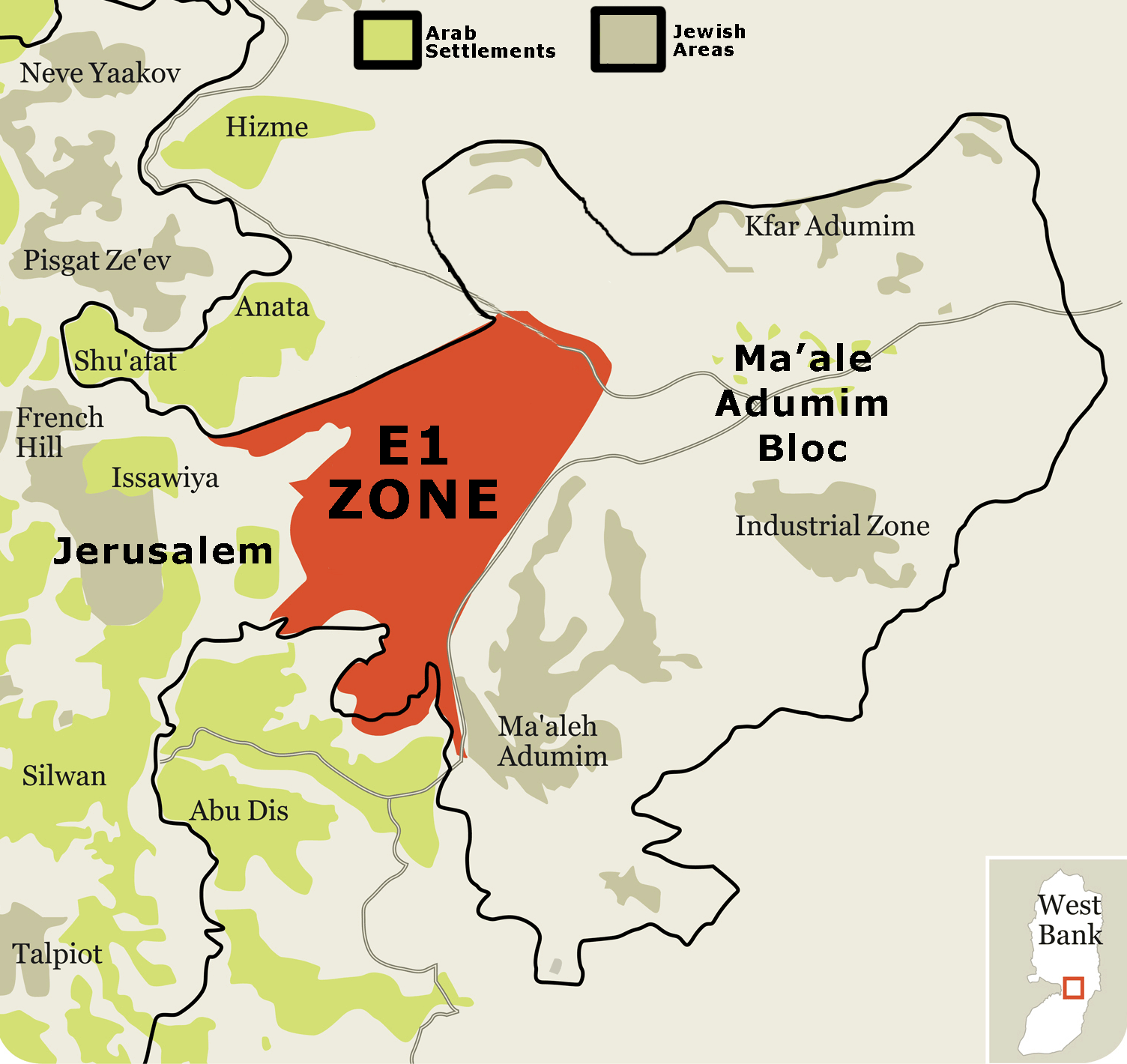
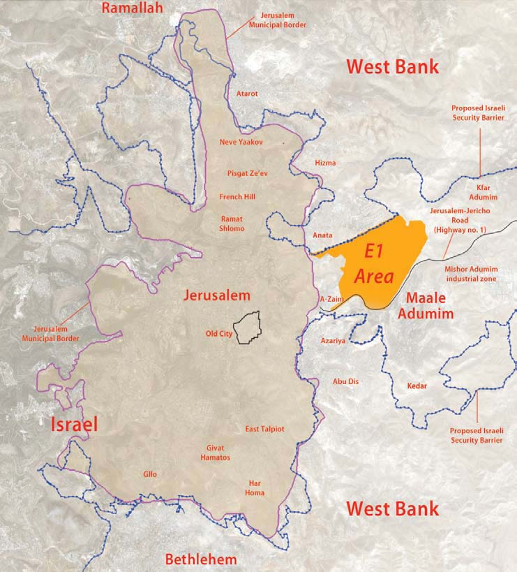
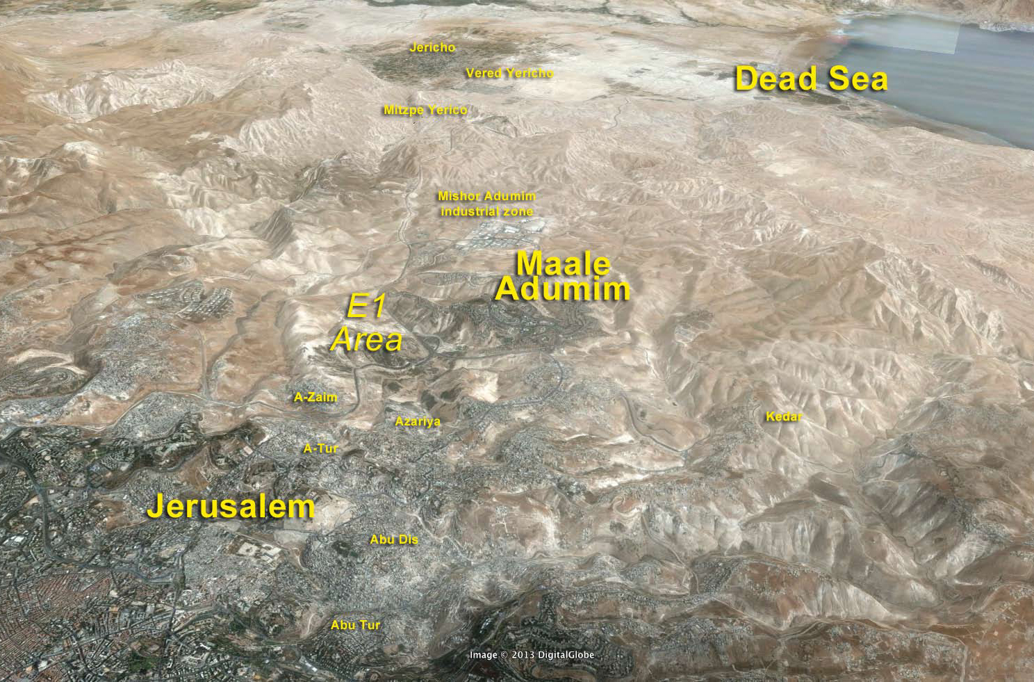
The E1 building plan covers about 4.6 square miles of mostly state-owned land along the Jerusalem–Ma’ale Adumim corridor, extending north and west of the main road. Its goal is to connect Ma’ale Adumim—a city of over 40,000 residents founded in 1977—directly to Jerusalem’s Mount Scopus ridge. Over half of E1 is designated as green space.
Ma’ale Adumim lies four miles east of Jerusalem on the Jerusalem–Jericho road, near neighborhoods such as Pisgat Zeev, French Hill, and Ramat Eshkol. Economically and culturally tied to Jerusalem, and lacking a major urban center of its own, the city functions mainly as a suburb of the capital. The two are linked by Highway 1, allowing a five-minute drive via the French Hill and Mount Scopus routes.
E1 envisions three residential neighborhoods plus a commercial, industrial, and hotel zone. So far, only two neighborhoods—about 3,500 housing units—are planned. The northern neighborhood and the commercial-industrial hub, intended to create a continuous link to Jerusalem, remain frozen for planning and legal reasons unrelated to politics. A police station and road infrastructure have already been built.
Israeli Interests
Linking Jerusalem to Ma’ale Adumim is a critical Israeli interest for several reasons:
Prevent Isolation: Ma’ale Adumim cannot become another Mount Scopus (1948–1967), an isolated enclave with only a vulnerable road connection.
Maintain Continuity: Security and urban continuity between Jerusalem and Ma’ale Adumim are essential. Allowing a return to Jerusalem’s pre-1967 “border-town” status would block the city’s natural eastward growth.
Protect Strategic Arteries: The Jerusalem–Jericho road—vital for troop movements to the Jordan Valley in wartime—is increasingly threatened by illegal Palestinian construction.
Ensure Defensible Borders: The Ma’ale Adumim–E1 area provides strategic depth to defend Jerusalem and Israel’s eastern front.
Preserve Jerusalem’s Metropolitan Area: The settlement belt around Jerusalem integrates security and development, reinforcing the capital’s viability.
National Consensus: Across the political spectrum, Israelis agree: Ma’ale Adumim must be linked to Jerusalem through E1 and remain under Israeli sovereignty in any final borders.
Palestinian Opposition
The Palestinian campaign against E1 began immediately after the Taba talks in January 2001. During those negotiations, Israel presented a map of Ma’ale Adumim that included the E1 area. Until then, Palestinians had generally accepted Israeli annexation of major settlement blocs—including Ma’ale Adumim—in the framework of land swaps. However, Israel’s inclusion of E1, along with territory stretching further east toward the Dead Sea, triggered a sharp reversal. The Palestinians withdrew their prior consent regarding Ma’ale Adumim and launched a concerted effort to mobilize international opposition to the plan.
The Bypass Road Proposal
The Palestinians oppose both the plan and the solution that Israel proposes for ensuring transportation continuity between the northern and southern West Bank. The solution Israel is offering the Palestinians is the use of what is effectively a bypass road (the literal Hebrew term is “fabric-of-life road”). This road would pass between Ma’ale Adumim to the east and Jerusalem to the west, allowing the Palestinians free movement from the Ramallah area to the Bethlehem area.
The bypass road will have two lanes. First, there is a lane for vehicles that have exited the Israeli security envelope; therefore, there is no concern that they could pose a security risk. Second, there is a lane for traffic coming out of the Palestinian security envelope, which Israel cannot be certain about from the standpoint of security. This separation of traffic into two lanes is not based on religious, ethnic, or national distinctions since Palestinian Arab residents of Jerusalem and Israeli Arabs will be expected to use the lanes for Israeli traffic.
Where traffic from both security systems converges on one road, Palestinian vehicles would have to undergo time-consuming security checks at roadblocks. The bypass road is designed to enable rapid north-south movement in the West Bank without interference from Israeli security authorities.
The Palestinian opposition to the bypass road is based on the claim that a transportation link alone between the northern and southern West Bank is unsatisfactory. In the wake of the Oslo accords, however, the roads in the West Bank became essential arteries for both the Palestinian and Jewish populations, with a dual use: for common transportation, and to create separation and prevent friction between the communities.
The basic concept of a road as not only a means of transportation but also a solution to political problems was initially accepted by the Palestinian Authority (PA) as a way to create a “safe passage” linking Gaza and the West Bank. The Palestinians and the Israelis compromised on the “safe passage” issue, each conceding a principle: the Palestinians gave up contiguity between the West Bank and Gaza, while Israel agreed to the creation of a passage with some attributes of foreign land within its own territory.
Roads like the proposed bypass already exist. There is a separate road for Palestinian traffic, for example, on the underpass road between Bidu and el-Jib in the Givat Zeev area. Road 443 between Jerusalem and Modiin, which mostly serves the Jewish population, is crossed by passageways that serve Palestinians only. The old Road 60, running north-south along the central mountain ridge from the Wadi Harima area southward to the Beit El and Ramallah areas, currently serves Palestinians only. The section of old Road 60 from Karmei Tzur in the direction of Halhoul also serves Palestinians only, as does the road eastward from Ofra through Taibe in the direction of Kochav Hashachar and Rimonim, and the passage through Beitin (between Ofra and Beit El). Jews, meanwhile, are not allowed to travel on the old Jerusalem-Hebron road that passes Solomon’s Pools and Deheishe; only Palestinians may use it. These roads provide direct and convenient transportation links that enable both Israelis and Palestinians to reach their destinations without unnecessarily passing through areas that would complicate or lengthen their travel.
Illegal Palestinian Building
Delaying E1 construction carries a double cost for Israel. First, the critical link between Jerusalem and Ma’ale Adumim—vital to ensuring this strategic area remains part of Israel—remains unbuilt.
Second, Palestinian and Bedouin encroachment is accelerating. Under the Oslo II Interim Agreement, this land is designated Area C, giving Israel zoning authority. Yet Arab villages such as Abu Dis, Azariya, A-Zaim, and Isawiya have expanded illegally, building without permits to preempt the E1 plan. Security officials note that Bedouin migration into E1 is partly driven by fears of being excluded from the separation fence, which is planned to encompass the Adumim bloc, including E1.
|
European organizations, elements associated with the PA, and even the PA itself—according to military sources—often support this illegal construction. UNRWA (the United Nations Relief and Works Agency) further entrenches the Bedouins’ permanent presence by providing food, winter equipment, and medical care as if they were refugees. European groups fund the makeshift schools the Bedouin have established, while the PA helps supply buildings and water containers.
Illegal Palestinian construction has even spread into municipal Jerusalem, north of Highway 1, at a site known as Sha’ar Mizrach. This area, about 180 dunams (roughly 0.7 square miles) in Anata, is mostly Jewish-owned land with clear potential to link Jerusalem to E1. Yet the state neither allows the owners to exercise their property rights nor acts to halt Palestinian encroachment there.
Israel’s reluctance to intervene stems largely from international pressure and opposition to any Israeli presence in the West Bank. Even efforts to comply with the law by relocating illegal squatters—after evacuation—to authorized settlement sites, such as the one established near Abu Dis in the late 1990s, have largely failed. Occasionally, the government issues demolition orders for structures built without permits. Almost invariably, however, violators, aided by advocacy groups, appeal to the Supreme Court against the Civil Administration, which enforces demolition and stop-work orders.
Over the years, this lack of enforcement has drastically narrowed the corridor between Jerusalem and Ma’ale Adumim—from about two kilometers (1.2 miles) to as little as one kilometer (0.6 miles) today. This shrinking corridor further constrains the prospects for construction in E1 and adjacent areas.
 |
Political Concerns
Since Yitzhak Rabin’s second term in the 1990s, every Israeli government has recognized the strategic and urban necessity of connecting Jerusalem to Ma’ale Adumim, stretching toward the Dead Sea and the Jordanian border. This principle is central to Israel’s security and urban planning doctrine, which views Jerusalem and its surrounding Jewish communities as a single metropolitan entity—what planners call “metropolitan Jerusalem.” Ensuring such continuity is not merely a matter of urban design; it is a core security imperative, maintaining defensible borders and protecting the capital.
The E1 plan has been the focus of intense international controversy, primarily driven by Palestinian claims that it would “bisect” the West Bank and render a future Palestinian state geographically unviable. Yet, as journalist Dan Perry notes, this claim is “somewhat true but also misleading,” since existing road networks, tunnels, and bypasses ensure Palestinian territorial contiguity, even if E1 development proceeds. Moreover, he noted, all major peace initiatives—such as Clinton’s 2000–2001 parameters, the 2003 Geneva Accord, and Prime Minister Ehud Olmert’s 2008 proposal—included Israel annexing Ma’ale Adumim and the connecting corridor to Jerusalem in exchange for an equivalent area of Israeli land.
Despite repeatedly affirming Israel’s sovereign right to develop Ma’ale Adumim and implement the E1 plan, successive prime ministers have swiftly bowed to American pressure—often within 24 hours of announcing construction—freezing or coordinating development with the United States. The pattern underscores that Israel’s urban and security priorities are routinely subordinated to foreign diplomatic sensitivities, even when international concerns are based on exaggeration or misrepresentation.
Construction Approved
Ignoring longstanding opposition, Finance Minister Bezalel Smotrich announced plans to build about 3,400 housing units between Jerusalem and Ma’ale Adumim. A decision he called “historic,” and “a significant step that practically erases the two-state delusion and consolidates the Jewish people’s hold on the heart of the Land of Israel.” Emphasizing the point, he added, “The Palestinian state is being erased from the table not by slogans but by deeds. Every settlement, every neighborhood, every housing unit is another nail in the coffin of this dangerous idea.”
This is precisely why the international community has been adamant in its opposition to any settlement in E1. On August 21, 2025, the UK, EU, and 24 other nations condemned the decision, calling it a violation of international law that endangers the two-state solution by dividing a potential Palestinian state and restricting Palestinian access to Jerusalem. In May 2026, the UK, France, Germany, Italy, Canada, Australia, New Zealand, Norway and the Netherlands warned contractors who bid on E1 housing construction tenders risk “legal and reputational consequences.” The countries insisted building in the area was illegal, the first time they threatened construction companies building in the West Bank.
In another sign of the Democratic Party in the United States taking more critical positions toward Israel, 88 members in the House of Representatives (far short of a majority of the House) signed a letter dated June 5, 2026, to Secretary of State Marco Rubio urging the Trump administration “to use every available diplomatic tool to halt the advancement of settlement construction in the E1 area of the West Bank.”
Sources: Nadav Shragai, “Protecting the Contiguity of Israel: The E-1 Area,” JCPA, (May 24, 2009);
Nadav Shragai, “Understanding Israeli Interests in the E1 Area: Contiguity, Security, and Jerusalem,” JCPA, (2013);
Nadav Shragai, “The End of Building Freezes in the Jerusalem Area,” JCPA, (March 8, 2020).
Jeremy Sharon, “Planning body gives final approval to controversial E1 West Bank settlement project,” Times of Israel, (August 20, 2025).
Dan Perry, “Israel’s new gift to the far right could help end the Gaza war,” Forward, (August 20, 2025).
Jeremy Sharon, “E1 settlement project widely condemned, but is it fatal to two-state solution idea?” Times of Israel, (August 25, 2025).
Liza Rozovsky and Matan Golan, “‘Breach of International Law’ Western Nations Call on Israel to Halt Internationally Condemned West Bank E1 Area Construction,” Haaretz, (May 22, 2026).
Jacob Magid, “85 House Dems urge Trump to back up anti-annexation rhetoric with action against E1 settlements,” Times of Israel, (June 5, 2026).
Excerpts courtesy of the Jerusalem Center for Public Affairs.