The Ottoman Empire
British Mandate Era
1967–Today
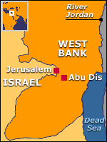
Abu Dis or Abu Deis (Arabic: أبو ديس) is a Palestinian village in the Jerusalem Governorate of the Palestinian Authority bordering Jerusalem. It is situated on an ancient site, surrounded by deep valleys. Ruins have been found of ancient buildings, cisterns, grape presses and caves, one with a columbarium. Ceramics from Late Roman and Byzantine period has also been found.
The Ottoman Empire
Abu Dis was one of the most populous villages in the Sanjak of Jerusalem under the Ottoman Empire during the 16th century, with a population of several hundred. Wheat and barley formed the bulk of cash crops, but were supplemented by grapes, olives, fruit trees, beans, and products from goats and bees. Descendants of Saladin lived in the village and were entrusted one-third of the grain revenue by the Ottoman Empire.
In October 1553, Shaykh Sa’d al-Din al-Sharafi al-Maliki was appointed as the administrator of the waqf of the village, but was replaced in 1554 by Muhammad al-Fakhuri at the request of three prominent villagers who complained to the qadi of Jerusalem. He remained in this position until 1563.
In 1596, Abu Dis appeared in Ottoman tax registers as being in the Nahiya of Quds of the Liwa of Quds. It had a population of 80 Muslim households, and paid taxes on wheat, barley, olive trees, vineyards, fruit trees, goats and/or beehives.
An official Ottoman village list from around 1870 indicated that Abu Dis had 52 houses and a population of 326 males (women were not counted).
In 1883, the Palestine Exploration Fund’s Survey of Western Palestine described Abu Dis as a “village of moderate size in a conspicuous position on a bare flat ridge, with deep valleys round it. The water-supply is from cisterns. Rock-cut tombs exists to the west.
In the late 19th century, the Sheikh of Abu Dis, Rasheed Erekat, promised to guarantee the safety of European tourists and pilgrims on the journey down to Jericho and the River Jordan. According to a 19th-century traveler, the “only way of accomplishing the journey to the Jordan ...(is) by paying the statutory tribute-money to the Sheikh of Abu Dees. This man has the privilege of extracting some sixteen shillings from each traveler who goes down to Jericho...He will send a man, possibly his own son along with you... arrayed in gorgeous apparel, and armed with sword and revolver.”
In 1896, the population of Abu Dis was estimated to be about 600 persons.
British Mandate Era
In the 1922 census of Palestine conducted by the British Mandate authorities, Abu Dis had a population of 1,029, all Muslims, increasing in the 1931 census to a population of 1,297, still all Muslims, in 272 houses.
In between those censuses, the town suffered extensive destruction in the 1927 Jericho earthquake. All the homes were damaged and every cistern was cracked. Since Abu Dis depended on rain-water cisterns for its water supply, this caused great hardship
In 1945, Abu Dis had a population of 1,940 Muslims, with 27,896 dunams of land, according to an official land and population survey. Between 1922 and 1947, the population of Abu Dis increased by 110%.
According to the UN General Assembly Resolution 194 in 1948, Abu Dis was to be the most Eastern part of the corpus separatum Jerusalem area. However, in the wake of the 1948 Arab–Israeli War, and after the 1949 Armistice Agreements, Abu Dis came under Jordanian rule.
In 1961, the population of Abu Dis was 3,631.
1967–Today
In the 1967 census Abu Dis had a population of 2,640.
In 1993, Israel and the Palestinians signed the Declaration of Principles that marked the beginning of peace negotiations. Soon after, Al-Quds University, one of the largest Palestinian educational institutions in the West Bank, was formally established in Abu Dis.
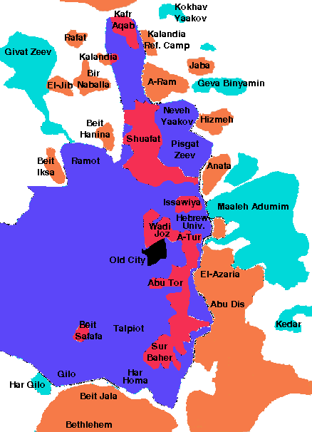
After the signing of the Oslo Accords in 1995, 85.2% of Abu Dis land was classified as Area C, under full Israeli control, while the remaining 14.8% is Area B, where civil affairs are under the control of the Palestinian Authority and security matters are the responsibility of Israel.
One of the most contentious issues in the negotiations was the future of Jerusalem. As Dusan Vranic explained, “The village of Abu Dis was seen then by some as an elegant solution to the conflicting Israeli and Palestinian claims on Jerusalem. Located outside the Israeli-delineated city limits it is nonetheless considered part of the Jerusalem district by the Palestinian Authority.”
In 1995, Abu Mazen (Mahmoud Abbas) reached an agreement with Israeli negotiator Yossi Beilin to establish the Palestinian capital in Abu Dis. That agreement was never officially signed by either side; nevertheless, the following year, the Palestinians constructed a parliament building in Abu Dis. Vranic noted, the “top-floor offices in the building offer a view of the revered al-Aqsa mosque in the Old City just a few kilometers (miles) away. Legend has it that one of those rooms was reserved for use of the late Palestinian leader Yasser Arafat.”
The Palestinian parliament never used the building and it has remained empty.
At the 2000 Camp David summit, Israel proposed that the Palestinians merge several communities, including Abu Dis, to create the city of Al-Quds, which would serve as the capital of Palestine. The government of Ehud Barak authorized the transfer of Abu Dis from Area B status to Area A if the PA disarmed the Tanzim, but the PA refused.
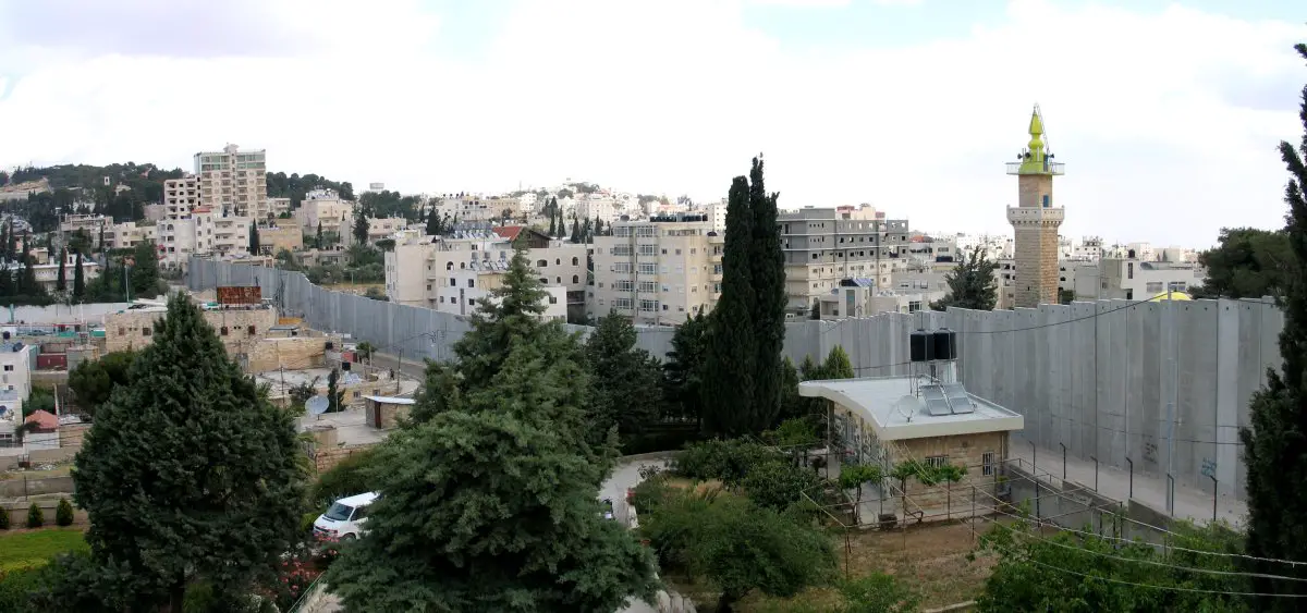
In response to a wave of suicide bombings and other terrorist attacks which became known as the “Al-Aqsa Intifada,” Israel began constructing a security barrier in 2003 to separate Israel from most of the West Bank. In Jerusalem, this consists of a wall that divides Abu Dis from the rest of Jerusalem.
President Trump’s peace plan envisioned that the security barrier would mark the border of Israel and Palestine and that the capital of the Palestinian state would include Abu Dis: “The sovereign capital of the State of Palestine should be in the section of East Jerusalem located in all areas east and north of the existing security barrier, including Kafr Aqab, the eastern part of Shuafat and Abu Dis, and could be named Al Quds or another name as determined by the State of Palestine.”
Abbas, who had agreed in 1995 to make Abu Dis the Palestinian capital, said in 2020 following the release of the Trump plan, “We will not accept Abu Dis or Al-Eizariya, as the capital of the Palestinian State.” He declared, “Without Jerusalem, which was occupied in 1967, we will never accept this state.”
According to the Palestinian Central Bureau of Statistics (PCBS) census, Abu Dis had a population of 12,604 in 2016.
Sources: “Abu Dis,” Wikipedia;
“2000 Camp David Summit,” Wikipedia;
Dusan Vranic, “Unfinished Palestinian parliament a grim symbol,” AP, (July 6, 2018);
Adam Rasgon, “Abbas confirms Palestinians being offered Abu Dis as capital of future state,” Jerusalem Post, (January 14, 2018);
“The 2000 Camp David Summit, the Clinton Plan, and their Aftermath,” Jerusalem Center for Public Affairs, [Undated];
Hilary Andersson, “Jerusalem: Difficult divisions,” BBC, (July 19, 2000);
Stephen Farrell, Rami Ayyub, “Abu Dis, an unlikely capital for a future Palestinian state,” Reuters, (January 29, 2020);
Adam Rasgon, “In Abu Dis, the notion of becoming capital of Palestine is deemed ‘preposterous,’” Times of Israel, (February 5, 2020);
“Abbas: We will not accept Abu Dis or Al-Eizariya as capital of Palestinian State,” Middle East Monitor, (February 8, 2020).
Photo of wall: Wikimedia - Yann licensed under the Creative Commons Attribution-Share Alike 3.0 Unported license.
Jerusalem Map: IRIS