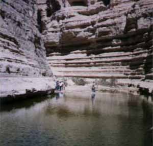
GeographyThe Ein Avdat Canyon is part of Nahal Tzin - the largest wadi that begins in the Negev. The wadi bed of Nahal Tzin suddenly becomes active amidst and following torrential rainfall and drains into what once was the southern end of the Dead Sea (the sea slowly dries up on its southern end). Nahal Tzin begins along the northwestern rim of Makhtesh Ramon, 20 km. south of Avdat and heads north. The Ein Avdat Canyon section of the wadi cuts into the northern edge of the Avdat Plateau. The canyon marks an abrupt change in Nahal Tzin's route. Below the canyon the wadi breaks east beneath the hanging Tzinim Cliffs. Among these cliffs many spectacular canyons, rich in water sources, drop into Nahal Tzin. There is a theory that initially Nahal Tzin continued northwards and joined Nahal Habesor, and its waters eventually reached the Mediterranean Sea. When the Arava valley was formed, the wadi which was former Nahal Habesor was "captured" by a newly developed Nahal Tzin flowing from the west to the east. Due to a sharp drop in the height (150 m), the waters of Nahal Tzin carved canyons along its way. Prehistoric artifacts were found in the area, helping to date the change in Nahal Tzin route to a few hundred thousand years ago. It is possible that the Ein Avdat canyon was formed only 80 000 years ago. The springs in the Ein Avdat canyon emerge from between horizontal layers of rocks. The source of the water is still not known definitely. The region is arid, and during rainfall the runoff does not infiltrate, but drains away along the wadis. The current theory is that the springs come from flash flood water that has seeped down through the stream bed gravel. HistoryThe Ein Avdat surroundings have been visited and inhabited by different people for thousands of years, but apparently only in a sporadic pattern. Throughout the Avdat Plateau and Sdeh Tzin by Sde Boker, numerous prehistoric flint artifacts have been found. The greatest number of flint tools was found near Rosh Ein Mor, at the top of the northwestern cliff of the canyon right above Ein Avdat. The tools belonged to the Neandertalean Musterian Culture (80,000-90,000 years ago). A few ostrich egg shells and onager bones help to describe the fauna of the epoch. The abundance of flint in the outcrops nearby were utilized by the Musterians for many types of tools such as arrows, points, etc. This archaeological site assists physical geographers in understanding the development of the Ein Avdat Canyon. There is a theory that in those days there was possibly no abrupt cliff, but rather a shallow stream bed like the one a kilometer upstream along Nahal Tzin, and the Ein Avdat canyon didn't exist yet. By the head of nearby Ma'ale Divshon is a large concentration of flint tool remnants and samples of man-made knives and other hand held stones. The tools date to the Paleolithic end Mesolithic periods (60,000-10,000 years ago). Between Ein Avdat and Ein Mor, on a small hill in the canyon, there are remains of a small settlement consisting of several round structures from the Mid-Bronze I. The region was inhabited again a thousand years later, but at Ein Avdat there have not been any finds from this time. During the Hellenistic period, the nearby city of Avdat became a station along the Nabatean Spice route. Other regions in the Negev were not inhabited and there was no agriculture at the time. Between 37 B.C.E. and 70 C.E., the Nabatean Empire peaked as the forts of the Spice route became thriving cities with many public buildings along with farming at the outskirts. The Nabatean kingdom flourished in the Negev for a thousand years. In 106 CE, the Negev was incorporated into the Roman Empire, but the Nabatean traders and farmers continued to service the Spice Route. In the Byzantine period when Avdat developed into a Christian city, the Ein Avdat Canyon was inhabited by monks. Christian pilgrims filled the Negev roads. After the Muslim conquest, in the seventh century, the roads to the West were blocked. Eventually, the region was abandoned. The place became easily accessible in the 1950s, after the establishment of the kibbutz Sde Boker and the road to Eilat. The trail going through it was constructed in 1956, and now it is the part of Israel National Trail. The Ein Avdat National ParkThe Ein Avdat national park encompasses the canyon for all its length. There are two entrances - the northern one an the bottom of the canyon, and the southern one at its top, separated by a distance of a ten-minute drive. Lately the trail traversing the canyon was left open only for ascent, so the visitors can start their route from the lower entrance and climb up to the upper one if they have a car that will pick them up. If they must return to the lower entrance, they can turn back before the last short segment of the trail. Another possibility is to arrive to the upper entrance and to enjoy the magnificent panorama of the canyon without entering it. Visitors arriving to the northern, lower entrance of the canyon can see a tiny spring of Ein Mor just across the parking lot, It is at the right side of a riverbed near two tall Euphrates poplar trees. In the cliffs above Ein Mor, at Rosh Mor, the prehistoric flint tools were found. The trail continues along the riverbed, the canyon grows narrower and its walls are taller. A lone Atlantic terebinth tree on the left from the trail is estimated to be 350 years old. After this tree the stream bed begins to carry water, and soon the trail reaches the most impressive point of the site. The two walls of the canyon close, and from the height of 15 m. a waterfall splashes into a deep pool, divided into two parts by a small artificial dam. The pool is 8 m. deep, and the water very cold. Swimming in the pool has been recently forbidden. The water of the spring is a bit salty, and the pool is surrounded with saltbush - a a saline water loving plant. Tiny hairs on its leaves absorb the salt and then fall off, allowing the plant to survive. The accumulated salt makes green leaves look silvery. A stairway leading up is carved into the cliff some 100 meters before the waterfall. The stairs, first sculpted by Israeli teenagers in 1956, have been improved by the National Parks Authority. They lead to the beginning of the Avdat waterfall, and the trail continues further up. As it crosses and recrosses the stream, it reaches the grove of beautiful Euphrates poplars. A carved rock water channel is evidence of human activity here. It is possible that the area of the poplar grove was once a vegetable garden cultivated by the monks who lived in the nearby caves. For those wishing to return to the lower parking lot this is the best turning point (there is another trail from the upper parking lot going down, but it is much longer). From here the stairs and ladders lead to the upper entrance to the National Park. However, before the ascent there are other places worth noting and maybe visiting. Experienced hikers can turn left there and ascend from the poplars to pools of Ein Ma'arif. This spring is the initial source of the Ein Avdat waterfall. The place is accessible through the slippery rock, and special caution is demanded for climbing there. Another path, more convenient, turns right before the stairs and leads along the base of a cliff to a two room man-made hermit cave. This cave is one of the caves that were inhabited by monks during Byzantine times. It is decorated by a cross, incised above a niche that was cut open as a window. It seems that the main use of these hermitages was in the 6th century by monks from Avdat. Archaeologists have investigated four caves. In the caves are various sculpted shapes, carved for various reasons: closets, shelves, bars for hanging clothes, benches, stairs, water systems and more. In the second cave to the north a Greek inscription was found. It is a prayer to St. Theodoros, whose name adorns a monastery found in Avdat. The trail ends at the observation terraces showing the magnificent look of the canyon. The upper parking lot is nearby. The Ein Avdat reserve is a home for ibex, and also for
griffon and other birds of prey. Before the sunset, when the tourists
leave the area, ibex go out and start looking for food. Getting ThereThe arrival to the northern parking lot is by Road 40, some 45 km to the south from Beersheba. The road sign shows a turn to the left for Ben-Gurion's burial ground, and for Ein Avdat. To get to the southern parking lot, continue some 5 km to the south by Road 40. Sources: The Israeli Mosaic |