Charting the Holy Land: The First Modern Atlas
The "first modern atlas," Theatrum Orbis Terrarum, was published by Abraham Ortelius (1527-1598) in his hometown, that great center of printing, Antwerp. He started out as a map engraver, then turned to business but, apparently influenced by Mercator, the greatest cartographer of the age, he returned to mapmaking. First published in 1570, the Theatrum immediately won wide popularity with no fewer than twenty-five editions appearing during Ortelius's lifetime, and editions continued to appear till 1612. Among the fifty-three maps included, four are of the Holy Land. To the publisher's credit, he freely acknowledged the sources of his maps, a practice rarely followed by fellow cartographers. A map that became a prototype for the modern cartography of the Holy Land, "Palestinae sine Totius Terrae Promissionis Nova Descriptio" is credited to Tilemanno Stella in bold letters in the colorful cartouche which gives its title. Stella drew it in 15 5 7, influenced in his delineation of the coastline and Dead Sea by the maps of Jacob Ziegler, whose atlas of Palestine and environs acknowledges indebtedness to Ptolemy.
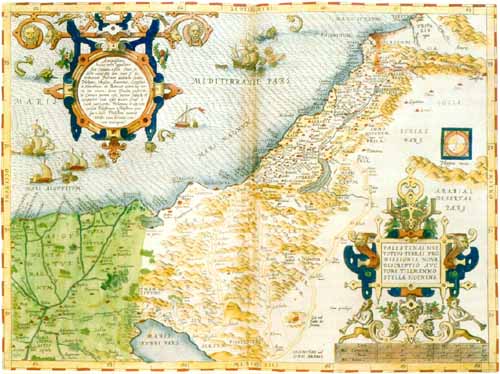 |
The map of the Holy Land that we take from the Library's 1575 Antwerp edition of the Ortelius Atlas has as its historical theme the Exodus from Egypt. The wanderings of the children of Israel in the desert are sharply delineated, each year of travel indicated from departure from Rameses to arrival at the Jordan. More central than the departure and arrival is the wandering, for the center of the map and its largest portion is the Sinai Desert.
Sources: Abraham J. Karp, From the Ends of the Earth: Judaic Treasures of the Library of Congress, (DC: Library of Congress, 1991).
Download our mobile app for on-the-go access to the Jewish Virtual Library