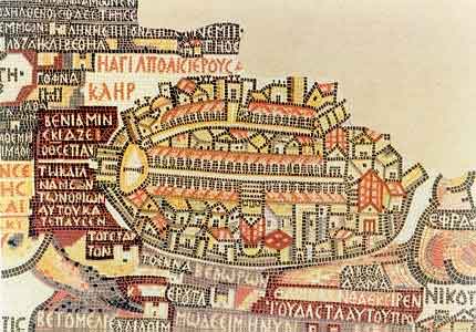
Maps of Pre-1948 Palestine: The Madaba Map
(565)
Maps of Pre-1948 Palestine: Pre-1948 Palestine Maps: Table of Contents
The Madaba Map is the oldest detailed cartographic document in the world. Made about the year 565 CE from more than two million colored stone cubes, the map formed the mosaic floor of a Byzantine church in the biblical town of Medeba, today Madaba in Jordan. It depicted the Holy land from Lebanon in the north to Egypt in the south. Jerusalem, the Holy City, constitutes the earliest urban mapping known.
 |
Sources: Israeli Foreign Ministry
Download our mobile app for on-the-go access to the Jewish Virtual Library