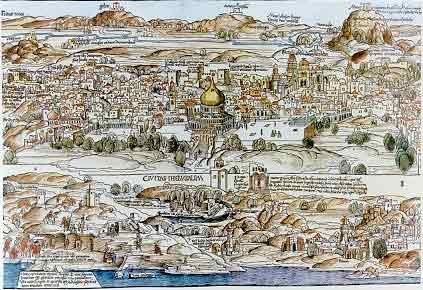
In 1483, Bernhard von Breydenbach, a nobleman and deacon of Mainz cathedral, Germany, made a pilgrimage to the Holy Land. After returning home he published a description of his voyage together with this map by Erhard Reuwich. The country is seen from the west (with a pilgrim's vessel near the coast at Jaffa) towards the east. However, the most important feature in the map is Jerusalem, drawn in minute detail as seen from The Mount of Olives westward, since this is the best viewing angle of the Holy City.
 |
Sources: Israeli Foreign Ministry