Water in Israel: Overview of Middle East Water Resources
(Updated December 1998)
Water is the most precious and valuable natural (and national) resource in the Middle East, vital for socioeconomic growth, sustainability of the environment, and—when considered to the extreme—for survival. This publication presents an overview of Middle East water resources in areas of Israeli, Jordanian, and Palestinian interest. Areal and site-specific hydrologic, meteorologic, and geologic data provided by water-resources agencies of the region are presented to allow a broad depiction of the overall water conditions in the region.
This publication was developed as part of the Middle East Water Data Banks Project, which encourages management and protection of water resources on a regional basis. Work was completed as a cooperative effort among the three Core Parties and was coordinated under the umbrella of the Water Working Group of the Middle East Multilateral Peace Process. The participating water-resources institutions are the Palestinian Water Authority, Jordanian Ministry of Water and Irrigation, and Israeli Hydrological Service.
Population and Water Supply
Climate
Physical Geography
Groundwater
Groundwater Basins
Groundwater Recharge
Groundwater Quality
Groundwater Levels
Springs
Surface Water
Watersheds
Dead Sea
Effects of Development of Water Resources on Dead Sea Water Level
Population and Water Supply
The available supply of water varies areally and temporally; and is influenced by climate, available water-resources technology, and management practices. Water use will continue to increase with population and economic growth and will be further influenced by the modernization of agricultural practices, as well as governmental, socioeconomic, and developmental policies.
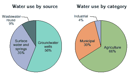 |
| Most of the region's water supply is pumped from groundwater; agriculture is the largest water user. Total withdrawals in 1994 were more than is naturally replenished in an average year. |
The supply of water is limited to that naturally renewed by the hydrologic cycle or artificially replenished by anthropogenic (human) activities. Period-ically, the amount of natural replenishment can exceed water demands during unusually wet periods or fall far below demands during drought periods. The reality of growing needs for a limited resource is one of the factors driving water con-servation efforts and considerations of alternate water sources.
Renewal of water resources depends on the overall amount of precipitation and is affected by temperature, evaporation and transpiration to plants (evapotranspiration), as well as rates of runoff and groundwater infiltration (recharge). On the western side of the Jordan Rift Valley, an average of approximately 30 percent (%) of the total precipitation that falls on the region is usable: 70% is lost through evapotranspiration, 5% is runoff, leaving 25% to recharge groundwater. On the eastern side of the Jordan Rift Valley, 90% of the total precipitation is lost to evapotranspiration, 5% is runoff, leaving only 5% for groundwater recharge. Of the 5% to 25% that infiltrates to groundwater, a portion eventually is discharged into streams or springs which then are classified as surface-water resources. The remaining infiltrated water is stored in the ground-water reservoirs (aquifers) and potentially is available for withdrawal from wells.
Water distribution systems, such as the Israeli National Water Carrier and the Jordanian King Abdullah Canal, distribute water from areas of water surplus to areas of water deficiency. The northern end of the King Abdullah Canal, shown here, receives water diverted from the Yarmouk River via a 900-meter (m) long tunnel.
Total water withdrawal in the region in 1994 was about 3,050 million cubic meters (MCM), of which 56% was withdrawn from wells, 35% from springs and surface-water sources, and 9% from wastewater reuse and artificially recharged water. The estimated total renewable water supply that is practically available in the region is about 2,400 million cubic meters per year (MCM/yr). There is then a water deficit in the region of about 375 MCM/yr that is being pumped from the aquifers without being replenished. Available water supply can be enhanced or expanded to a limited extent by desalination of brackish or sea water sources, leak reduction in infrastructure systems, water awareness and conservation where appropriate, dam construction and/or enlargement, and the increased use of treated wastewater.
Climate
 |
|
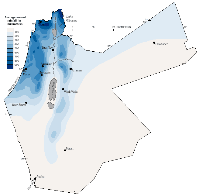
Average annual rainfall, in millimeters.
|
Natural replenishment of water resources in the Middle East varies greatly, as shown below on the map of average annual rainfall which exhibits large changes in relatively small distances across the region. A Mediterranean-type climate, characterized by a hot, dry summer and cool winter with short transitional seasons predominates in the northern, central, and western parts of the region. The eastern and southern parts of the region have a semi-arid to arid climate. Winter begins around mid-November and summer begins around the end of May. Rainfall occurs mainly during the winter months.
The Middle East experiences extreme seasonal variations in climate, as shown below in graphs of average monthly rainfall, potential evaporation, and average daily maximum and minimum temperatures for various locations. Large rainfall variations also occur from year to year, as shown in the graph of annual rainfall for Jerusalem. Consecutive years of relatively high or low annual rainfall have an enormous effect on the region and, in the case of dry years, present the greatest challenge to manage the region's precious water resources. These consecutive-year patterns also may affect water-use practices, policies, and expectations.
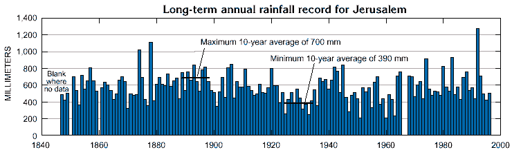 |
| At Jerusalem, the wettest year of record, 1992, had six times more rainfall than 1960, the driest year of record. Consecutive wet years provide sustained increases in flow to springs and streams, and groundwater recharge. Conversely, consecutive dry years produce hydrological droughts. For example, the wettest 10-year period on record, 1889–98, had 1.8 times more average annual rainfall than the driest 10-year period, 1925–34. |
Climate characteristics exhibit large changes from one area to another and across seasons and years. As shown on the rainfall map, average rainfall decreases from west to east and from north to south, ranging from 1,200 millimeters (mm) at the northern tip of the region to less than 50 mm in the desert areas. Rainfall less than 200 millimeters per year (mm/yr) constrains development of rainfed agriculture in about half of the area on the western side, and 90% of the area on the eastern side of the Jordan Rift Valley.
Temperature also varies across the area, generally according to latitude and altitude and by physiographic province (see next pages for description of provinces). The hilly areas of the Mountain Belt and Jordan Highland and Plateau experience cold winters and hot summers. In Amman and Jerusalem, average daily mean temperatures for January range from about 7 to 9 degrees Celsius (°C), whereas, in summer, the average mean temperature is about 24 °C. Average daily mean temperatures in the Jordan Rift Valley area range from about about 15 °C in the winter to about
| WHAT IS A WATER YEAR? The hydrologic year runs from October 1 to September 30. Year dates in the graphs and text of this report refer to water years, not calendar years. |
31 °C in the summer. In the Coastal Plain, average daily temperatures are between 16 and 22 °C in the winter and between 20 and 31 °C in the summer. The desert region has a continental climate with a wide range of temperatures. In August average daily maximum temperatures are between 34 and 38 °C. In winter, the air is very cold and dry with an average daily minimum temperature between 2 and 9 °C. When air from a cold, polar origin penetrates the region, temperatures decrease to below the freezing point. The region periodically experiences very hot days during the spring and autumn, called Sharav or Khamasini, that may produce temperature rises from 10 to 20 °C above average, and reach from 40 to 45 °C in many areas.
Physical Geography
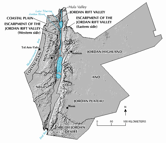
Coastal Plain — Located along the Mediterranean Sea, the Coastal Plain is home to over one fourth of the region's inhabitants. It is characterized by a flat topography with a white-sand shoreline, bordered by fertile farmlands. The Coastal Plain is formed by the emergent surface of the continental shelf, consisting of thick Nile-derived sediments covered by eolian sands of Quaternary age.
Mountain Belt — Formed of sedimentary rocks originally deposited as flat layers that were folded in southern and central areas. In northern areas, including the mountains west of Lake Tiberias and their transverse valleys, the sedimentary rocks were offset by faulting. The Mountain Belt rises to elevations from 500 to 1,200 m above sea level. Cooling of coastal air masses as they rise over the mountains in northern areas results in relatively high rainfall.
Negev — An arid zone that does not support a large popu-lation. In the northern Negev, Upper Cretaceous and Tertiary sedimentary rocks were folded into a northwest-oriented mountain belt. The central Negev is charac-terized by low sandstone hills and plains. These highly erodible areas are deeply incised by wadis which flow after winter rains and often produce flash floods. Further south, the region becomes an area of volcanic craters, rock-strewn plateaus, and rugged mountains. Several large east-west oriented faults occur in the Negev.
Jordan Rift Valley — This dominant physiographic and geologic feature is a 375-kilometer (km) long strike-slip fault zone that affects the climate, hydrology, and anthropogenic activities of the region. Vertical displacement of the faults of more than 3,000 m resulted in the development of the Hula Valley, Lake Tiberias, and the Dead Sea. The elevation of the rift valley drops to about 400 m below sea level at the present shores of the Dead Sea, the lowest point on the surface of the earth. North of the Dead Sea, the valley has long been used for agriculture because of avaliable water from the Jordan River and numerous springs along the flanks of the valley.
Western and Eastern Escarpments of the Jordan Rift Valley — Formed as the Jordan Rift Valley deepened, causing abrupt valley walls and deeply incised wadis across the escarpments. The area is characterized by deep canyons that cut through Upper Cretaceous sedimentary rocks into underlying rocks of Precambrian to Lower Cretaceous age.
Jordan Highland and Plateau — Jordan Highland consists mainly of deeply-incised Cretaceous sedimentary rocks that rise to elevations of as much as 1,200 m. These elevations drop gradually eastward toward the Jordan Plateau, which is characterized by flat open country with shallow incised wadis draining inland toward the various depressions. Basalt flows have markedly smoothed the relief in parts of the plateau.
South Jordan Desert — Extremely arid region characterized by mountains of exposed Paleozoic sandstone, dune deposits, and exposed Precambrian crystalline rocks near the Red Sea. Several extensive northwest-southeast oriented fault occur in this area.
Groundwater
Groundwater from wells and springs is the most important source of water supply in the region, providing more than half of the total water consumption. Groundwater is contained in openings in water-bearing rock units called aquifers. The volume of the openings and the other water-bearing characteristics of the aquifers depend on the mineral composition, texture, and structure of the rocks. Groundwater generally moves very slowly and follows the least resistive (most permeable) pathway from the point of recharge (where water enters the aquifer) to the point of discharge (where water leaves the aquifer). Shallow groundwater generally moves at rates up to one meter per day or greater. An exception is in aquifers that have conduit-like openings, such as basalt and karstic (cavernous) limestone, where water may move much faster. Deeply circulating groundwater moves extremely slowly—sometimes as little as a meter or less per century.
The flow of groundwater may be inhibited by non-water bearing rock units called aquicludes. Aquicludes typically consist of clay, silt, or shale which do not transmit water readily, although they may hold much water in pore spaces. Aquicludes influence patterns of flow in aquifers by restricting groundwater movement. Confined aquifers occur where an aquifer is filled by water and is overlain by an aquiclude. Unconfined aquifers occur where an aquifer is not overlain by an aquiclude. Geologic structure (lithology) also controls flow patterns in aquifers, either by providing barriers restricting flow or by providing a less-resistive pathway for flow. The geologic structure and topography determines if the groundwater will be discharged as springs or remain underground until tapped by wells.
The importance of an aquifer as a source of water may change from one area to another because of changes in demands for freshwater, variations in groundwater quality, and differences in the hydrogeologic characteristics. Lithologic changes in a formation may result in its being an aquifer in some locations and an aquiclude in others. The most productive aquifers of the region are in Quaternary sand and gravel in the Coastal Plain; Cretaceous limestone in the Mountain Belt, eastern and western escarpments of the Jordan Rift Valley, and Jordan Highland; basalt of the Jordan High-land and Plateau; and sandstone of the South Jordan Desert. Other aquifers include water-bearing zones of limestone and sandstone of lower productivity. Water occurs in pore spaces in the sand and gravel, pore spaces and cavernous zones in the limestone and sandstone, and in fractured zones in the basalt.
Freshwater supplies may be obtained from wells drilled to shallow depths in the Coastal Plain and Jordan Rift Valley; and from deeper wells (as much as 650 m) in the Mountain Belt, Jordan Highland and Plateau, and the desert regions. Generally, water depths are greatest in the mountain ranges and desert regions, and shallowest in valley floors and in the Coastal Plain.
In addition to wells, springs provide a source of water supply from aquifers and form the headwaters of many streams and wadis. Springs occur where the water table intersects the surface topography and are common where geologic structures, such as faults, provide an outlet for groundwater discharge. Springs represent visible discharge from aquifers; invisible or concealed discharges include seepages, evaporation, transpiration to plants, and hidden springs. Under natural conditions, aquifers discharge water in an amount proportional to total annual infiltration (recharge).
Groundwater Basins
Groundwater resources of the region are subdivided into groundwater basins on the basis of:
- a natural boundary that does not change with time, such as one determined by structural features, intervening layers, or aquifer extent;
- a boundary that may change with time, such as an underground watershed or groundwater divide which may change in response to pumpage or recharge; or
- a boundary designated solely for administrative or operative reasons.
Although many basins have been designated by the various water-resources institutions in the region, in this report groundwater resources are generalized into 20 basins solely on the basis of hydrogeological factors. These include ground-water divides of the most important regional aquifer system, the limits of an aquifer, or important physiographic features.
The natural boundaries of one aquifer will not coincide with those of another aquifer. Thus, a basin may contain several aquifers of different ages and areal extent occurring at different depths.
Groundwater Recharge
Although a rock formation may have properties favorable for storage of water, it must be in contact with a source of water for replenishment (recharge) to provide a continual supply of water. Groundwater is derived from two origins: (1) fossil, which receives no or only a very small amount of recharge; or (2) recent and renewable.
Fossil aquifers are non-renewable and are found mostly in the southern and eastern parts of the region. Water probably infiltrated the fossil aquifers tens of thousands of years ago, when the prevailing climate was more humid. Because water pumped from fossil aquifers is not replenished, groundwater levels show a continual decline as the water is "mined" from beneath the ground.
Recent and renewable recharge is derived naturally from precipitation, or from streams, wadis, lakes, ponds, or other impoundments that seep through soil into the aquifers. In addition, recharge may be induced by anthropogenic activities that are intentional, such as injection wells or seepage ponds, or unintentional, such as irrigation seepage, wastewater infiltration, or pipe leakage.
Estimates of annual ground-water recharge for the 20 groundwater basins were derived by the various water-resources agencies of the region and are illustrated below. Estimates were determined by summing all points of discharge, with the assumption that this sum equals aquifer recharge. For each groundwater basin estimated recharge includes:
- discharge into surface runoff, including measured spring discharge and estimated discharge into surface-water bodies;
- pumped discharge from wells (measured);
- evapotranspiration (roughly estimated from regional setting and estimation from other areas); and
- underground outflow to adjacent basins.
Recharge is generally highest in the mountainous northern part of the region where precipitation is greatest. The percentage of annual precipitation recharging the aquifers is dependent on the rates of evaporation, transpiration to plants, runoff, and soil permeability.
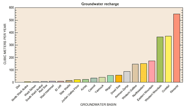 |
| Estimated recharge rates are highest in the coastal and mountain basins, and least in the southern and eastern basins. These patterns generally correspond to the distribution of precipitation in the region. |
Groundwater Quality
Groundwater quality can be affected by both natural and anthropogenic activities. In aquifers unaffected by human activity, the quality of groundwater results from geochemical reactions between the water and rock matrix as the water moves along flow paths from areas of recharge to areas of discharge. In general, the longer groundwater remains in contact with soluble materials, the greater the concentrations of dissolved materials in the water. The quality of groundwater also can change as the result of the mixing of waters from different aquifers. In aquifers affected by human activity, the quality of water can be directly affected by the infiltration of anthropogenic compounds or indirectly affected by alteration of flow paths or geochemical conditions.
Contamination of fresh groundwater by saline water is a common problem in the region. Salinity of groundwater generally is measured in terms of total dissolved solids or dissolved chloride. In humid areas and where recharge is abundant, potential groundwater salinization is limited because of the natural flushing by freshwater. Conversely, in semiarid areas, the absence of natural flushing by freshwater enhances the accumulation of salts and saline water. Natural sources of saline water include:
- encroachment of sea water near the Mediterranean Sea and Red Sea;
- upward migration of highly pressurized brines in the Jordan Rift Valley and other areas; and
- subsurface dissolution of soluble salts originating in rocks throughout the region.
East of the Jordan Rift Valley and Wadi Araba, water at depths of a few hundred meters below land surface generally is saline. Within these areas of generally high salinity, it is possible that a local source of acceptable, relatively fresh water exists. Heavy pumping in some areas has led to water-level declines and changes in flow directions in the aquifers. In some cases, this has induced saline water from the sea or deep brines, to move into and contaminate an aquifer.
In addition to natural sources, groundwater quality can be affected by agricultural, municipal, and industrial activities in the recharge zone of the aquifer. Potential sources of contamination include recycled irrigation water, wastewater from human activities, and waste by-products from industrial activities. Nitrate is an important constituent in fertilizers and is present in relatively high concen-trations in human and animal wastes. In general, nitrate concentrations in excess of a few milligrams per liter indicate that water is arriving at the well from shallow aquifers that are polluted from human or animal waste, or from excess nitrates used in agriculture. Water-quality changes for selected groundwater basins are described in the following sections.
Groundwater Levels
Changes in water levels in wells reflect changes in recharge to, and discharge from an aquifer. Recharge rates vary in response to precipitation, evaporation, transpiration by plants, and surface-water infiltration into an aquifer. Discharge occurs as natural flow from an aquifer to streams or springs, as evaporation and transpiration from the shallow water table, as leakage to vertically adjacent aquifers, and as withdrawal from wells. Where water-level changes are due to withdrawals, they also may reflect changes in groundwater flow direction. Water-level changes for selected groundwater basins are described in the following sections.
Springs
Springs have been used for thousands of years as an important source of water supply in the region. Springs are places where groundwater discharges through natural openings in the ground and are common in areas of cavernous limestone or basalt. Springs may vary greatly in the volume of water they discharge; some springs are so small that they occur only as seeps where water oozes slowly from the aquifer, whereas others, such as the Dan Spring, are large enough to form the headwaters of large streams. Springs flowing from water-table aquifers tend to have small, extremely variable flows and are influenced greatly by climatic conditions. Such springs may cease flowing during periods of low precipitation. Springs issuing from confined aquifers have larger and more consistent flows, and show less influence from climate than do water-table springs.
Springflow is controlled by the size of the recharge area, the difference in altitude between the spring opening(s) and the water level in the aquifer, and the size of the opening(s) through which the spring issues. In addition, climatic conditions and pumping of wells located near the spring may influence flows.
Flow characteristics of selected springs are presented on the following three pages in graphs showing annual flow volume and statistical summaries of monthly flow volume based on the period of record. Quality of spring water is indicated by graphs showing chloride and nitrate concentrations.
Surface Water
Surface water in most of the region drains to the Mediterranean, Red, or Dead Seas. In the large desert watersheds, most streams flow only in response to storms and drain internally, the water evaporating or infiltrating the ground. Surface water is very limited in the region because of generally low rainfall and high evapotranspiration. However, nearly all of the available, fresh surface water is used and together with springs supply about 35% of total water use in the region. Streamflow characteristics change rapidly across the region and closely follow precipitation patterns. Annual streamflow generally declines from west to east with distance away from Mediterranean moisture sources, and from north to south with increasing temperature and evaporation. Streamflow typically is higher on the western side of the Mountain Belt, due to temperature and orographically induced precipitation, and decreases on the eastern side of the Mountain Belt descending into the Jordan Rift Valley.
Watersheds
The location and boundaries of the major watersheds of the region are shown above. Watershed size is a poor indicator of relative flow because of the extreme differences in climate across the region. Few streams outside the Jordan River watershed have adequate baseflow from ground-water and springs to flow throughout the year. Many streams of the Mediterranean and Dead Sea watersheds flow throughout the rainy season and are dry during the summer. Streams of the Wadi Araba and Desert watersheds typically flow only in response to winter storms. Peak flows typically occur during February and March, lagging the peak precipitation period by about one month. This lag time is due principally to the balancing of extreme moisture deficits in parched soils and plants after the dry season. Flood events may also occur following intense storms in the spring and fall months.
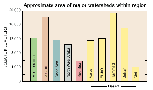 |
| Natural flow characteristics of streams in the region are related first to watershed location with respect to rainfall patterns, and secondly, to watershed size. |
The Mediterranean watershed includes the Coastal Plain and parts of the Mountain Belt and Negev. The streams generally have small watersheds with headwaters in the western mountains. Many of the streams are affected by water supply diversions and wastewater discharges.
The Jordan River watershed has the largest water yield in the region and provides most of the usable surface-water supply. The annual flow volume of the upper Jordan River above Lake Tiberias is about three times greater than the combined annual volume of the streams in the much larger Mediterranean watershed. The Jordan River watershed is in the Mountain Belt, Jordan Rift Valley and Escarpments, and the Jordan Highland and Plateau. The largest tributary to the Jordan River is the Yarmouk River, which is the principal surface-water resource for Jordan. The Jordan River is perennial throughout its course, but its flow downstream from Lake Tiberias is substantially reduced in quantity and quality.
The Dead Sea watershed includes streams with headwaters in the eastern side of the Mountain Belt, the Eastern and Western Escarpments of the Jordan Rift Valley, and the Jordan Highland and Plateau. The larger of these streams, such as the Wadi Wala and Wadi Mujib, flow perennially during their steep decent into the lowest point on the surface of the earth.
The North and South Wadi Araba and the Red Sea watersheds contain ephemeral streams that typically flow only during winter storms that may cause dangerous flash floods in the deeply incised wadis. The watersheds are in the Negev, the Jordan Highland and Plateau, the Jordan Rift Valley and Eastern Escarpment, and the South Jordan Desert. Near the mouth of the Hiyyon River lies the internal divide of the Wadi Araba from which water flows north to the Dead Sea or south to the Red Sea.
Large parts of the Jordan Highland and Plateaus and the South Jordan Desert physiographic provinces are characterized by Desert watersheds that drain internally. Stormwater flows in these streams generally decrease in the downstream direction as water is lost through evaporation and infiltration. The stream courses of the El Jafr watershed provides a vivid example of this.
The following pages describe the flow characteristics of selected streams in the region. Measured annual flow volumes are shown in a column chart at the lower right corner of each page. The median annual flow volume of a site may be compared to other regional streams in the column chart at the lower left corner of each page. The graph of monthly flow volume illustrates the seasonal flow characteristics for each stream. Median monthly flows may be regarded as characteristic for the stream site, while the minimum indicates whether a zero flow condition has been observed for each month. The maximum flow indicates the range of flow and the magnitude of floods that have been observed on the stream.
Dead Sea
| Located near the center of the region, the Dead Sea lies at the terminus of the Jordan River, flowing in from the north, and the Wadi Araba to the south. The shallow southern basin has been separated from the main water body by declining water levels and now contains manmade evaporation ponds. |
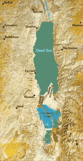 |
The Dead Sea is the terminal lake of the Jordan Rift Valley. It is the lowest point on the surface of the earth, and the waters have the highest density and salinity of any sea in the world. The east and west shores of the Dead Sea are bounded by towering fault escarpments that form part of the African-Syrian rift system. The valley slopes gently upward to the north along the Jordan River, and to the south along the Wadi Araba. Historically, the Dead Sea is composed of two basins: the principal northern one that is about 320 m deep (in 1997), and the shallow southern one from which the Dead Sea has retreated since 1978. The two basins are divided by the Lisan (or Lashon) Peninsula and the Lynch Straits, which has a sill elevation of about 400 m below sea level.
The closed watershed of the Dead Sea is 40,650 km2 . Most of the water flowing to the Dead Sea comes from the relatively high rainfall areas of the Jordan River watershed to the north, and the rift valley escarpments to the east and west of the Dead Sea. To the south, the Wadi Araba watershed covers the arid regions of the Negev and South Jordan Desert. The climate in the watershed varies from snow capped Mount Hermon (Jabel El Sheik), with annual precipitation in excess of 1,200 mm, to the arid regions of the southern Negev, where annual rainfall averages less than 50 mm. Over the Dead Sea itself, average annual rainfall is about 90 mm and the annual potential evapotranspiration is about 2,000 mm. Actual evaporation ranges from about 1,300 to 1,600 mm and varies with the salinity at the surface of the Dead Sea, which is affected by the annual volume of freshwater inflow. The average temperature is about 40 °C in summer and about 15 °C in winter.
The water level of the Dead Sea has a seasonal cycle. Prior to development of water resources in the watershed, the peak water level occurred in May and the low occurred in December, as shown for the period 1935-55 in the bottom graph on the next page. Within-year variation ranges from 0.3 to 1.2 m for most of the period of record. Intensive development of freshwater in the Dead Sea watershed has altered the seasonal variation in water level, typically increasing the decline and decreasing the rise.
The water level of the Dead Sea has been monitored continuously since 1930, and has declined over 21 m from 1930 to 1997. Such a large decline raises questions of whether there are precedents for this water-level change and whether they can be explained by normal vari-ances in climate. Fortunately, evidence of histori-cal Dead Sea water-level changes may be found from several independent sources.
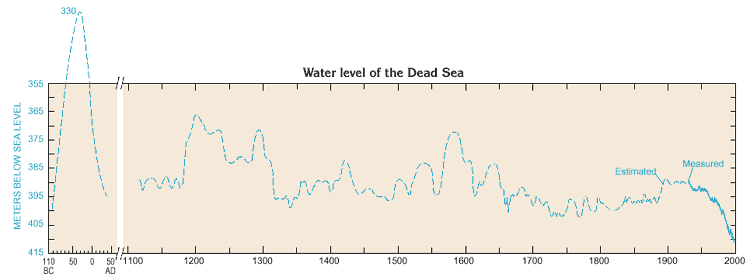 |
| Historical water-level records of the Dead Sea have been reconstructed for a period of over 1,000 years, including the very large rise and fall in water level around the first century B.C. (modified from C. Klein, 1985). |
As shown above, there are many precedents in the historical record of larger, more rapid water-level changes than the 21 m decline over the last seven decades. Furthermore, the historical range of water-level fluctuations is about 83 m, nearly four times the 21 m decline in this century. Should further water-level declines reveal submerged trees, or should traces of historical submergence be found at elevations higher than 330 m below sea level, the historical range would increase.
The largest change in water level shown on the estimated historical hydrograph occurred between about 100 B.C. and A.D. 40. Within this period, the water level of the Dead Sea rose some 70 m, from about 400 m to about 330 m below sea level (where Qumran was inundated) in about 67 years; and subsequently fell some 65 m in about 66 years. A second large rise, not shown on the graph, occurred between A.D. 900 and 1100 and crested at about 350 m below sea level. Could these extreme changes in stage be explained by climate fluctuations?
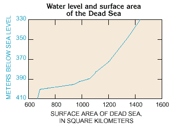 |
| The surface area of the Dead Sea is known to have varied between about 1,440 km2 at its historical high of about 330 m below sea level, and about 670 km2 at 410 m below sea level, a greater than twofold difference. There is a corresponding difference in the volume of water lost to evaporation each year. |
To address this question, investigators have made computer simulations of increased rainfall and runoff in the Dead Sea watershed, accounting for evaporation losses. These simulations indicate that rapid water-level changes on the order of 70 m over a 67-year period could occur if inflow increased by 33 to 48% over an average inflow condition. Likewise, persistent years of below average rainfall could cause rapid declines in the water level. Historical references lend weight to this conclusion. There are historical references to abundant harvests during the period of the rising Dead Sea water level prior to about 67 B.C., and there was severe drought during the period of the falling Dead Sea water level recorded by Josephus Flavius for 25-24 B.C. when Herod had to sell his treasures in order to buy corn from Egypt for the population.
The Dead Sea balances increased inflows not only by a rise in water level but also by increased evaporation losses. As the water level of the Dead Sea rises, its surface area increases causing a corresponding increase in the volume of evaporated water. The greater than twofold increase in surface area between the elevations of 410 and 330 m below sea level would increase the annual volume of evaporated water from 1,005 to 2,160 MCM, assuming a constant annual evaporation of 1,500 mm per year. Evaporation during periods of high water level is further accelerated by the dilution of saline waters near the surface, because in reality evaporation is not constant but increases as salinity decreases.
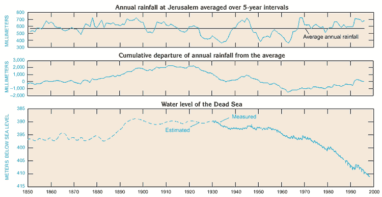 |
| Water-level trends of the Dead Sea respond to measured rainfall trends in the watershed, except for the last three decades, when the effects of water use dominate the water-level trend. |
Long-term fluctuations of the Dead Sea water level are caused by periodic fluctuations in rainfall over the watershed. The year-to-year water level is steady when the volume of water leaving the Dead Sea by evaporation is equal to the volume flowing in from perennial streams, flash floods in the wadis, and springs and seeps draining the groundwater. The water level rises following seasons of abundant rainfall and declines during drought years, as shown above in the graph of water level and rainfall from 1850 to 1997. In this graph, rainfall patterns in Jerusalem are assumed to be indicative of Mediterranean- based rainfall patterns over the Dead Sea watershed. When the annual rainfall is above average for several years, there is a cumulative effect (shown in the cumulative departure curve) leading to a rise in water level, such as occurred from about 1882 to 1895. The cumulative effect of below average rainfall periods leads to declining water levels as seen in 1930-36, and 1954-63.
Effects of Development of Water Resources on Dead Sea Water Level
During the last four decades, water resources in the Dead Sea watershed have been intensively developed to meet growing demands for this precious resource. Increasing amounts of water were diverted from surface and groundwater sources in the watershed to meet domestic, agricultural, and industrial needs. Since 1964, only a fraction of the flow from the water-rich areas of the upper Jordan River leave Lake Tiberias to move toward the Dead Sea. Most of this water and water from the Yarmouk and Zarqa Rivers is diverted for uses inside and outside the watershed. Under current conditions on an average annual basis, the combined inflow from all sources to the Dead Sea has been estimated as only one-half to one-fourth that of the inflow prior to development. Water also is pumped from the Dead Sea itself into evaporation ponds constructed in the shallow southern basin.
The influence of rainfall and water-resources development on Dead Sea water levels is illustrated in the graph above. Until around 1970, Dead Sea water levels and rainfall showed a correlation. For example, a falling trend in Dead Sea water levels during 1954-63 corresponds to a period of below-normal rainfall. This downward trend was interrupted by above-normal rainfall that produced a rise in water levels during 1964-69. Since about 1970, however, the historical correlation between rainfall and Dead Sea water levels appears to deviate. Although rainfall generally increased during this period, water levels declined steeply, corresponding to decreased inflows from the Jordan River. Although the effects of rainy years in 1980, and especially 1992, are still evident, their influence on Dead Sea water levels is moderated. Development of water resources will result in a more pronounced impact of droughts on Dead Sea water levels. Thus, Dead Sea water levels continue to offer a record of the integrated effects of historical climate and water-resources development in this watershed.
Sources: U.S. Geological Survey, Water Data Banks Project, Multilateral Working Group on Water Resources, Middle East Peace Process.
Download our mobile app for on-the-go access to the Jewish Virtual Library