The map below shows the areas of the West Bank over which Yasser Arafat's Palestinian Authority (PA) has jurisdiction according to the interim agreements between Israel and the PLO, as of December 2000. Explanatory notes follow.
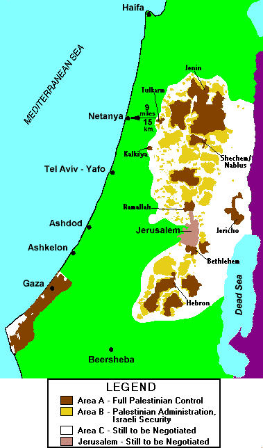
In Area A (brown), the main Arab urban areas, Israel has fully withdrawn. This constitutes 18% of the West Bank. The PA has complete control over all civilian administration, and its paramilitary police force is in charge of security.
Note how close these areas come to Israel’s main civilian centers, such as Jerusalem, Tel Aviv, Haifa, Beersheba and Netanya. The Kalkilya zone practically borders on the Israeli city of Kfar Saba (not shown), and both the Ramallah and Bethlehem zones border on Jerusalem. (Nearly all of the Gaza region is also considered part of Area A.)
In Area B (yellow), the Arab towns and villages, the PA has full civilian authority but it shares security responsibility with Israel. Joint Israel-PA patrols operate here. In practical terms, Israel has very little presence. Nearly all of the strategic mountainous high ground is covered by Area B, which represents 22% of the West Bank.
Area C (white) consists mainly of uninhabited desert regions to the east and south. All Jewish communities and Israeli military bases are also part of Area C, as enclaves. Area C includes all the main roads between Jewish communities and also between the Arab towns in Areas A and B. It constitutes 60% of the West Bank.
The pink region marks the current municipal boundaries of Jerusalem.
Source: IRIS