Charting the Holy Land: Jerusalem as the Earth’s Center
The Land of Israel is the holiest of Lands.
Numbers Rabbah
The Sages of Israel proclaimed:
The Land of Israel is the center of the world.
Jerusalem is the center of the Land of Israel.Midrash Tanhuma
A thirteenth -century crusader map places Jerusalem at the center of the earth. Heinrich Bunting's world map in his Itinerarium Sacrae Scripturae, Helmstadt, 1581, of which the Library has a copy, depicts the earth as a three-leaf clover, each leaf being a continent: Europe, Asia, and Africa. The three are drawn together by a ring encircling a single city; that city is Jerusalem.
City and land are holy to the three great faiths of western civilization-Judaism, Christianity, and Islam. The Jew is bound to the Land by God's promise to Abraham: "Unto thy seed will I give this land" (Genesis 12:7)-this once and eternal homeland where Patriarchs trod, where Prophets preached, where ancestors began the eternal quest to know God's word and do God's will. For a millennium and more, the people Israel lived in Zion; for two millennia Zion lived in this people. Thrice daily the Jew turns in his devotions towards the Holy City. The Passover seder ritual and the Yom Kippur (Day of Atonement) liturgy conclude with the pledge and prayer, "Next year in Jerusalem."
For the Christian, the Land is the birthplace of his Lord and the site of His ministry. Jerusalem is the scene of His passion and resurrection, and when in the "end of days" He will rise again, it will be in that city, in that Land. For the present, it is a land for pilgrimage and prayer. To the Moslem, Jerusalem is holy, the city the Prophet Mohammed chose for his ascent to heaven from the sacred spot now enshrined in the Dome of the Rock.
Memory and holiness are joined in this land, where as Disraeli said in Tancred, "not a spot is visible that is not heroic or sacred"; where, as the Hebrew poet Micah Joseph Berdichevsky observed, "every stone is a book and every rock a graven tablet." Jews and Christians in every age were avid recipients of news of the Holy Land. Pilgrims made the hazardous journey there and returned to tell their tales, retold by word of mouth and often set in print. Whatever the description-holy places in ruin, a new folk and a new faith resident in sacred cities-it was the ancient land and city which continued to live in the imagination of the faithful. The best known of early Christian pilgrims was Helena, mother of Constantine the Great, the first Christian Roman emperor. Late in her life, about the year 320, she journeyed to the Holy Land to find the sacred sites. Her quest inspired the founding of churches and became the subject of legend.
Fifteen centuries later, Lady Judith Montefiore accompanied her husband Sir Moses on the second of his seven pilgrimages. in her travel journal she describes her coming to Jerusalem:
Thursday, 6 June 1830. What the feelings of a traveler are, when among the mountains on which the awful power of the Almighty once visibly rested, and when approaching the city where he placed his name; where the beauty of holiness shone in its morning splendor; and to which, even in its sorrow and captivity, even in its desolation, the very Gentiles, the people of all nations of the earth, as well as its own children, look with profound awe and admiration.... As we drew nearer to Jerusalem ... the Holy City itself rose full into view, with all its cupolas and minarets reflecting the splendour of the heavens. Dismounting from our horses, we sat down and poured forth sentiments which so strongly animated our hearts in devout praises to him whose mercy and providence alone had then brought us a second time, in health and safety, to the city of our fathers.
Pilgrims were few. Most experienced pilgrimages only in their imagination. Their imagination was informed, oft fired, by accounts heard or read, by pictures seen and by maps and charts which were as much history as geography. The armchair pilgrim could, in some measure, vicariously experience the emotions of St. Helena and Lady Judith by perusing maps of the Holy Land and charts of the Temple, twelve of which we briefly note.
With the Rosenwald Collection came the first travel book ever printed. Bernhard von Breydenbach's Peregrinatio in Terram Sanctam (Journey to the Holy Land), Mainz, 1486. In his Treasures of the Library of Congress, Charles A. Goodrum notes that in that volume are "the first travel pictures ever produced of a real scene drawn realistically, and were also the first known foldout inserted in any publication." One such foldout is a minutely drawn picture of Jerusalem and its "environs," which extend to Tripoli and Alexandria.
Bernhard von Breydenbach, a member of the German nobility and Dean of the Cathedral at Mainz, resolved in his later years "to undertake a pilgrimage to the Holy Land in hope of obtaining the salvation of [his] soul." Accompanied by Erhardus Revwich, a recognized woodblock artist, he set out for Jerusalem on April 25, 1483. When they returned to Mainz nine months later, the Dean and the artist collaborated on a book describing and depicting their pilgrimage. Breydenbach wrote the text while Revwich provided the illustrations, the first ever made to accompany a text. The book became an instant success. The original Latin text was translated into German four months after its publication (1486), and later into French (1488), Dutch (1488), and Spanish (1498). No less than eight editions made it the most popular travel book in Europe up to the discovery of the New World.
The plate reproduced here is a schematic "tourist map." A partially walled Jerusalem occupies half the space. Below it is the land separating it from the Mediterranean. Pilgrims are debarking from a galley and making their way towards the city. The modern tourist will immediately recognize the Dome of the Rock. In the upper left is the Sea of Galilee and Tiberias; in the lower right Alexandria, and high above, Mount Sinai. It presents a charming and, all things considered, faithful depiction of holy sites as Breydenbach's entourage found them.
"Every writer on geography," R. V. Tooley states in his Maps and MapMakers (1949), "has paid tribute to the work of Ptolemy. He stands like a colossus astride the ancient world, and his influence is still felt today. Claudius Ptolemaeus (Alexandria 90-168), astronomer and geographer, achieved pre-eminence in both these branches of human knowledge ... His Geographia dominated the whole of the Christian and Moslem world for 1,500 years."
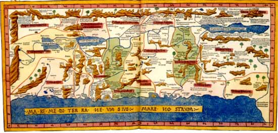 |
None of Ptolemy's maps has survived the classical period. They were, however, reconstructed in manuscript and engraved on copper or carved in wood for editions of the Ptolemy atlas. In 1482, the first woodcut edition, containing the first map of the world to include contemporary discoveries, was published in Ulm, Germany. It contains a brightly handcolored map of the Holy Land, which can be seen in a beautifully preserved copy in the vault of the Library's Geography and Map Division.
Kenneth Nebenzahl, in his Maps of the Holy Land (1986), informs us that the Ulm edition was based on a manuscript version of a Ptolemaic atlas by a German Benedictine Donnus Nicholaus Germanus, working in Florence, Italy. He, in turn, "copied directly" from "the first modern map of Palestine," that of Marino Sanuto and Petrus Vesconte, who produced it in Venice, c. 1320, a map whose influence, Nebenzahi asserts "extended through three hundred years."
The Holy Land is oriented with east at the top ... Mountains and rivers are carefully located ... Cities are placed close to their correct positions.
From the mountains of Lebanon, the Jor and the Dan descend to form the Jordan . . . Old Testament iconography is emphasized and includes the location of the Ten Tribes, a depiction of the Tomb of Job, and inscriptions marking where Lot's wife was turned into a pillar of salt.
The above features, as we shall see, presage those contained in the maps which followed.
Sources: Abraham J. Karp, From the Ends of the Earth: Judaic Treasures of the Library of Congress, (DC: Library of Congress, 1991).
Download our mobile app for on-the-go access to the Jewish Virtual Library