 |
ARCHAEOLOGYThe term archaeology is derived from the Greek words archaios ("ancient") and logos ("knowledge, discourse") and was already used in ancient Greek literature in reference to "the study of ancient times." In its modern sense it has come to mean the scientific recovery and systematic study of the material remains of ancient human cultures of prehistoric and historic date. Prehistory refers to that part of human existence that preceded the development of writing. To understand what happened in prehistoric periods, the archaeologist is obliged to rely much more on the interpretation of physical remains such as flint tools and cultic objects, habitations and burials, the assessment of the chronological sequencing of remains at sites, while also using an array of scientific techniques to gather information about climatic and environmental changes occurring in the past. Archaeologists dealing with the historic periods, however, are able to rely on a greater variety of artifacts and architectural remains, on the one hand, and on the discovery of written materials (notably inscriptions on durable materials, such as stone or clay tablets, and on ceramic ostraka, and to a lesser extent on organic materials, such as scrolls and papyri made of leather skins and parchment) on the other. The study of ancient writing is known as epigraphy, while the study of the development of individual written letter forms is known as paleography (see *Alphabet). The archaeological discipline incorporates within it numerous specialist fields of study, notably the investigation of ceramics (the study of *pottery forms and manufacturing techniques over time), *numismatics (the study of coins), archaeozoology (the study of animal and fish bones), and archaeobotany (the study of plant remains, pollen, and phytoliths). Archaeological data recovered during excavations are often supplemented with information derived from ancient literary sources (such as theological, narrative, or historical writings). Archaeology has an important role in illuminating the cultures of certain peoples referred to for example in the Bible, such as the Hyksos and Philistines (who were not at all boorish as one might think). This is also true of neighboring civilizations such as those of the Egyptians, Sumerians, and Hittites – without archaeology our understanding of these cultures would be very limited. Numerous "historical truths" based on literary sources have had to be re-assessed in the light of irrefutable archaeological finds, for instance the Israelite "conquest" of the Promised Land as recounted in the Bible (see below). Archaeology has much to contribute to the contextual clarification of the later classical and medieval periods as well, and a wealth of data now exists in textbooks and scientific publications. The cut-off period for archaeological investigations in Israel used to be the late medieval period (c. 1750), but recent decades have seen an interest in late Ottoman remains as well and archaeological work has even been conducted on features dating from as late as World War II. Methods and ApproachesThe modern archaeologist uses a variety of methods in gathering information about the ancient past, but surveys (surface explorations) and excavations (methodical digging operations) are two primary methods of recovering data. In the mid-19th century a shift occurred in terms of the methods used by scholars for understanding the history of the Syria-Palestine region and for the elucidation of biblical writings in particular. Prior to this the field of biblical interpretation was dominated by the writings provided by Jewish travelers and Christian pilgrims, in which uneven accounts of their observations of antiquities in the southern Levant were provided. Much of this information was collated while traveling the country along predetermined routes, under the supervision of local guides, and with the purpose of visiting sites that were primarily of biblical interest. The culmination of all this was the detailed work made by Robinson and Van de Velde, among others. E. Robinson, in particular, crisscrossed the country in 1838 and 1852 and his work ultimately led to the development of the systematic study of place names (topynoms) which was crucial for the identification of places mentioned in the Bible. However, the first systematic overall mapping of the country, with a regional investigation of monuments and sites possessing visible architectural remains from different periods, began with the work of the *Palestine Exploration Fund and undoubtedly one of its greatest achievements was the "Survey of Western Palestine" of the early 1870s. The SWP provided for the first time detailed topographical maps of the country to a scale of one inch to the mile, as well as a number of volumes of memoirs in which were described the sites and landscapes they encountered. The SWP maps have since
become an indispensable tool for all new archaeological surveys, even though the information provided was incomplete and by modern archaeological standards defective (e.g., artificial city mounds – tells – were not regarded by the explorers as sites of any archaeological significance). Subsequently, the Survey of Eastern Palestine was made in 1881–82 and then discontinued, the Arabah Survey in 1883–84, surveys east of the Jordan by G. Schumacher in 1885–86, and the Wilderness of Zin survey under T.E. *Lawrence and L. Woolley in 1913–14. An important survey of ancient synagogues in Galilee was undertaken in 1905–7 by H. Kohl, E. Sellin and C. Watzinger, and their book is still a basic textbook for the plans of ancient synagogues in the Holy Land. Until World War II, surveys conducted in Palestine were fairly basic in terms of the field methodologies and the means of dating that were employed. A "Schedule of Historical Maps and Sites" was prepared and updated by the Palestine Department of Antiquities at regular intervals from the 1920s. A new Archaeological Survey of Palestine was initiated in 1937, but very little progress was made. In July 1964 the Society for the Archaeological Survey of Israel was founded. Surveys were henceforth made within 10 × 10 kilometer maps, with the recording of archaeological remains by making measured plans of architectural remains, photography, and the collection and identification of surface artifacts (notably potsherds, flints, and coins). Since the 1980s Regional Archaeological Surveys have been conducted in various parts of Israel, with excavated tell sites placed within the context of the pattern of archaeological sites known in their specific regions. Site Catchment Analysis or Site Territory Analysis has been particularly useful for the study of the morphological environments of prehistoric sites, particularly in desert areas, and in recent years Landscape Archaeology has come to the fore especially in regard to the investigation of historical landscapes with rural and industrial remains. Historic Mediterranean type landscapes in the southern Levant tend to be regarded by archaeologists as places characterized by an assemblage of features pertaining to a variety of extramural human activities, such as agricultural pursuits (terraces and field systems) and industrial work (stone quarrying and lime and charcoal burning), all of which, of course, necessitated the establishment of a system of communications (roads and paths) so as to form links between farms and villages, and towns and markets. An in-depth study of such remains during a project of Landscape Archaeology can lead to a chronological and contextual understanding of ancient communities and how they adapted themselves to the specific environments they inhabited. The underlying assumption behind this kind of approach, however, is that communities will interact with each other and with the ecology of their environments, in a sensible, harmonious, and stable fashion. Some landscape features, however, reflect their adaptation as a physical means of advancing ideologies and strengthening power struggles and territorial conflicts. Excavation ("dirt archaeology") is the principal method used by archaeologists in the search for information about ancient cultures. W.F. *Albright once wrote that "excavation is both art and science" and M. Wheeler wrote that "there is no correct method of excavation, but many wrong ones." Numerous factors contribute to the choice of a site for excavation in the Land of Israel, including its historical importance (and biblical identification), chance finds of significance, the impressiveness or accessibility of a site, and observations made during earlier archaeological investigations. The choice of a site chosen for excavation also depends on the budget that the archaeologist and the sponsoring university can raise. The procedure of excavations requires a systematic removal of accumulated earth and debris covering ancient architectural remains, whether belonging to the site of a tell (i.e., a superficial mound created by the accumulation of superimposed layers of ruined ancient towns of different periods) or at the site of a one-period settlement (i.e., a place that was founded on natural land and after a time came to be destroyed or abandoned and never rebuilt). Various techniques of excavation exist and the choice of the techniques employed depends largely on the characteristics of the site being excavated. The first action that is taken in preparation for an excavation at a tell is to lay out a grid-system with iron rods set in cement along a north-south axis across the mound. These rods are used as the baseline for setting out a grid of 5 × 5 meter squares across the area chosen for excavation. By digging squares of 4 × 4 m within the larger grid the excavator is able to leave balks (unexcavated earthen walls) in place as the excavation deepens. Once the first occupation level has been encountered, the balks need to be recorded and taken down so that the general area of excavation will be sufficiently large enough to capture the outlines of more or less complete buildings, otherwise the archaeologist will be left with a series of fragmentary walls scattered within a grid of squares. However, key balks are left at appropriate locations to record the overall stratigraphy of the area under excavation. To ensure that this is properly organized the archaeologist appoints an area supervisor in each field of excavations, and they in turn take charge of monitoring the square supervisors. The excavating archaeologist is obliged to keep detailed written records of the daily findings, accompanied by photographic dossiers and surveyed architectural maps and drawings, and lists of objects found. The dig director is assisted by a qualified staff: archaeological area supervisors to supervise work in the various fields of excavations, a surveyor and architect, a finds curator/registrar, and an administrator to take care of the tools and budgetary matters. The success of a project often depends on the stamina of an archaeologist in dealing with logistics and organization, and with his/her ability to successfully communicate with people, whether with staff or locals. The archaeological work will include the careful analysis of the strata of a site made on the basis of constant stratigraphical observations of fills of soil and debris, using balks to record the gradual progress of the digging operations, looking at the structural relationships between various phases of building construction, examining foundation-and-robbers' A daily exchange of ideas on matters concerning the interpretation of the stratigraphy at the site between the dig director, site supervisors, and square supervisors is highly recommended while the excavations are in progress, all of which should be recorded as deliberations in available notebooks. Potsherds (and other finds) are collected in numbered buckets with labels identifying the loci they came from and these are recorded in the field diary. The pottery is subsequently washed and sorted. Dipping of sherds is undertaken at sites when ostraka (inscribed potsherds) begin appearing. The sorting of the potsherds and small finds in the excavation is an activity undertaken by the finds curator in conjunction with the entire staff on a daily basis. Volunteers or students help with the registering of finds. It is imperative for the success of the expedition that the site supervisors and square supervisors know exactly the date of the pottery coming from their areas. On-the-spot instruction on pottery retrieval may be provided by the finds curator, especially in regard to the excavation of floors where it is suspected that there are crushed vessels that might eventually be mended by a pottery conservator. A draftsperson will prepare drawings of the diagnostic pottery profiles, usually to a scale of 2:5, and these are appended to the finds cards with written descriptions (decorations, slips, glazes, grit inclusions, etc.) and Munsell color readings. In terms of digging techniques, the 19th century has to be regarded as a time of treasure hunting, to say the least, with Lady Hester Stanhope, for example, digging haphazard holes in the ground at Caesarea in order to extract Roman statues. Although the first tells were excavated in the 1860s by the explorer Charles Warren (at Jericho and Tell el-Ful), this was done without the realization that they in fact contained the ruins of ancient cities. Many explorers at that time excavated in the form of mining shafts, shored up with wooden struts, but this method was not at all conducive to the scientific gathering of data. The first methodological excavation of a tell was made in 1890 by Flinders-*Petrie, the "father of modern Near Eastern archaeology," at Tell el-Hesi in the southern Shephelah, and it was there that he first recognized that by studying the changing forms of ancient pottery vessels and their associated levels, one is able to trace the development of a city and its changing cultures through time. The need for planning and method on a dig was later made clear by Flinders-Petrie in his book, Methods and Aims in Archaeology (1904). A trained staff to accompany the chief archaeologist in the field was first employed by Reisner during his work at Samaria in 1908. The wide-scale excavation of tells was subsequently undertaken during the first half of the 20th century by many foreign expeditions, with an attempt to get down to those levels with biblical associations as quickly as possible. This rapid "stripping" of the superimposed city remains at tells – with the exposure of defense walls, gates, temples, administrative buildings, stores, and domestic dwellings – provided enormous amounts of hitherto unknown scientific data, but it also sometimes resulted in great harm to sites (e.g., at Gezer, which was excavated on a wide scale by R.A.S. Macalister with unskilled labor and without a trained backup staff). During the course of the 20th century scientific techniques of excavations improved considerably, with sensitive area-excavations of a more limited and solid scientific nature being conducted at tells, with careful stratigraphical and architectural observations being made, and with refined material studies of ceramic and environmental remains being initiated. This was the peak of "Biblical Archaeology" and the general public in Israel at that time was fascinated by the discoveries at tells, such as at Hazor, Lachish, and Beersheba. There was also excitement about discoveries relating to sites of Jewish interest from later periods such as at Masada, and in the 1970s in Jerusalem with the excavations close to the Temple Mount and in the Jewish Quarter. Recent decades have seen the development of a much more scientific discipline, with the flourishing of procedures such as radiocarbon and thorium-uranium methods The preparation of a new site for excavation requires the thorough study of the morphology of the site and the mapping of existing remains and surface features, using gps and other topographical surveying techniques. Having checked on surveys and excavations that might previously have been undertaken at the site in the existing literature, the next step is to check on the site records in archives, such as those at the Palestine Exploration Fund in London, the Israel Antiquities Authority in Jerusalem, and the foreign schools in Jerusalem. Surveys of sites on 10 × 10 km maps have been conducted since 1961 by archaeologists working for the Archaeological Survey of Israel (now the Survey Division of the Israel Antiquities Authority) and information about a site might be available there. Valuable information might also be obtained from geomorphological and geological maps, topocadastral maps, and aerial photographs. The latter are useful when deciding on the location of areas to be opened up on a mound site, with telltale features that might help pinpoint the location of fortification walls, gateways, the internal layout of the final settlement at the site (particularly from the Hellenistic period, or later). Some aerial photographs date back to World War I and may be important if the area around a tell has been substantially developed since then. Modern aerial photographs are useful in monitoring the progress of the dig from season to season. Once the background research has been done and the site has been selected and surveyed, the next stage is to secure the budget for the excavation and a license from the Israel Antiquities Authority. A budget for an excavation may be raised from grant-giving archaeological institutions worldwide or from private sponsors. To obtain the license the director of a potential dig needs to have a recognized academic qualification in archaeology, a pledge of sponsorship from an academic institution (preferably one's own affiliated university), and proof that one has the back-up staff and budget ready to undertake the excavation successfully. The budget has to cover not only the costs of the excavation itself, but also the costs of the conservation of the archaeological remains exposed (e.g., crumbling mosaic floors) and the costs of the post-excavation work (namely, pottery conservation, cleaning of coins, drawing of pottery, anthropological and zoological examination of bones, the identification of plant remains, radiocarbon determinations and other scientific tests). The preparation of the final archaeological report on the results of an excavation involves much work and time, but ultimately it is the most important part of the exercise. Without it an excavation will not benefit general archaeological research. An excavation may have been carried out with the best available standards but if it remains unpublished then it is close to useless. Thousands of excavations have been carried out in the Land of Israel since the beginning of the 20th century and the sad fact is that only a small percentage of these have actually been fully published. Hence, archaeologists nowadays set up classification and recording frameworks while the excavation is still in progress, to ensure a more rapid funneling of material towards publication later on. At a very early stage the various specialists dealing with scientific materials derived from the excavations, among them anthropologists, archaeozoologists, archaeobotanists, metal experts, and petrography experts, are called in to examine materials derived from the excavations. Archaeological experts on pottery, lamps, and coins are also called in, unless of course they are already part of the expedition. To facilitate their research the specialists and experts are provided with the maximum available information on the chronological/stratigraphical significance of the findspots of the materials they will be studying. Much of the preliminary archaeological work for the report consists of sorting through copious field notes and vast amounts of data that accumulated during the course of the excavation: notes on stratigraphy and architecture, notes on chronological considerations, parallels for pottery assemblages that have been drawn and analyzed, specialist lists of identified coins and small finds, identification lists of animal bones, shells, and so forth. In addition, the archaeologist keeps in mind the layout of the report and its structure when planning the necessary illustrative materials (line drawings and photographs). The final report ordinarily begins with a history of previous researches undertaken at the site, followed by a chapter on the environment of the site and its setting, a short summary chapter of the research aims of the new expedition and the methods employed, and, thereafter, the actual report itself with a detailed description of the remains uncovered and all the stratigraphical and architectural considerations. The report on the pottery from the site tends to be one of the most important expert chapters and this because pottery is extremely ubiquitous and ultimately serves as an important dating tool. Specialist reports, appendices, and tables/lists close the excavation report. The best reports are those that are written clearly and simply, with the avoidance of long-winded and complex descriptions. Technical History of Archaeological Research in IsraelInterest in the antiquities of the southern Levant (present-day Syria, Lebanon, Israel, Jordan, and Palestine) began as early as ancient times. All ancient peoples living in this region would have seen the monuments and ruins that were antecedent to their time and would have shown curiosity in their antiquity. The Jewish historian *Josephus Flavius already remarked in his writings on the evident antiquity of certain monuments and attempted to ascribe to them dates, for example in describing the fortification wall surrounding the Upper City of Jerusalem (the "First Wall") he suggested that it dated back to the time of David and the Israelite kings. While scholars once thought this was nonsense and that the wall was from no earlier than the time of the Hasmoneans (late second century B.C.E.), the subsequent archaeological excavation of portions of this wall in the 1970s revealed that earlier parts of it had indeed been built at the time of the Divided Israelite Monarchy, i.e., in the eighth century B.C.E. Hence, Josephus had got it partly right. One of the earliest descriptions of an excavation in Jerusalem, albeit in a story that may be partly legendary in character, is the one which refers to Helena, mother of Constantine the Great, digging in the early fourth century C.E. in a cistern close to the spot of the crucifixion of Jesus and finding there wooden remnants which she believed were from the holy cross itself. Throughout Late Antiquity the country was visited by numerous Jewish and Christian pilgrims and many of them left written records of their observations regarding the antiquities they came across during their travels. Numerous travelogues and itineraries of pilgrims who came to the Holy Land are extant from the time of the Crusaders onwards, and in the 17th and 18th centuries the pertinent materials were summed up by Quaresmius and Reland, and in the 19th century by T. Tobler and C. Ritter. Some of the important antiquarians of the region in the 19th century were E. *Robinson, V. *Guérin, C. *Schick, G. *Schumacher, among others. Proper methodical archaeological work in the region began with the work of the Palestine Exploration Fund from the 1860s onwards. Charles *Wilson conducted a survey of Jerusalem and its monuments in 1864–65, and this was followed by excavations in the city by Charles *Warren until the early 1870s with work being conducted especially around the edges of the Temple Mount. The earliest dig at a tell took place by Warren at two places in the 1860s, but the earliest scientific work at a tell was made by Flinders-Petrie at Tell el-Hesi in 1890, followed by the work of his assistant Frederic J. Bliss, who conducted additional work at Tell el-Hesi, as well as work in mining shafts on the slopes of Mount Zion in Jerusalem (together with A.C. Dickie). Together with R.A.S. *Macalister, Bliss also made open area excavation on four tells in the Philistia part of the Shephelah (the western foothills) between 1898 and 1900, and this because the Ottoman Law of Antiquities of that time permitted the granting of an excavation license not just for a single site but for an area of land of about four miles square and all the sites contained therein. The four sites were Tell es-Safi (Gath), Tell Zakariyeh (Azekah), Tell ej-Judeideh (Moresheth Gath), and Tell Sandahanna (Maresha). Most of the work was actually conducted at the latter site, which the excavators correctly identified as biblical Maresha and Hellenistic Marissa. Bliss wanted to expose the acropolis area of the site, layer by layer, but this proved impracticable and only the uppermost Late Hellenistic layer of the city was exposed. Having completed their work at these sites, they covered up their excavation areas in order to return them to the landowners as was required by Turkish law. This was followed by large-scale excavations at the beginning of the 20th century at *Gezer and *Samaria. At Gezer Macalister employed what he thought was a better system of excavations known as the "strip method" in which an area is excavated strip by strip, the rubble from succeeding strips being dumped into the previous ones. Although economical, this did not offer a satisfactory picture of the overall history of the site and much of Macalister's work at Gezer still remains difficult to understand. Excavations were conducted at this time by a number of German and Austrian biblical scholars and architects, at Tell *Taanach by E. Sellin (1902–4), *Megiddo by G. Schumacher (1903–5), and *Shechem by E. Sellin and C. Watzinger (1907–9), but the results were poor owing to the excavators' lack of training and skills in mound excavation. The excavations made at Samaria in 1908 and 1910–11, by D.G. Lyon, C.S. Fisher, and G.A. Reisner, were very important in terms of the careful excavation techniques and recording procedures that were employed there. Many objects from these early excavations – including the important *Siloam Inscription – ended up in the Ottoman Imperial Museum in Constantinople (Istanbul). With the establishing of the British Mandate over Palestine in 1920 archaeological excavations became much more systematic and scientific. This was the first "golden age" for archaeology in Palestine, between 1920 and 1940. All excavations were regulated by licenses issued in accordance with the new Antiquities Ordinance, prepared by J. *Garstang for the Palestine Department of Antiquities. The Department of Antiquities With the establishment of the State of Israel in 1948, Jewish archaeologists were cut off from the Palestine Archaeological Museum and the archives of the Department of Antiquities. In July of that year the Israel Department of Antiquities was established, with Shemuel *Yeivin as its first director, and its first archaeological activities were connected with sites under danger as a result of the new building developments in the country. Excavations conducted during these early years included work at Tell Qasile, Jaffa, and Beth Yerah. Large-scale excavations were subsequently conducted by Y. *Yadin at *Hazor during the 1950s and in 1968, and many Israeli archaeologists received their first fieldwork training at this important site. This was the second "golden age" of biblical archaeology in the country. The 1960s saw important excavations at *Arad and *Ashdod, the Judean Desert Caves survey (1961–62), which brought to light important finds from the time of Bar Kokhba, and the expedition to *Masada. Numerous excavations were conducted at tell sites throughout the country during the 1970s and 1980s, from Dan (A. Biran) in the north to Beersheba (Y. *Aharoni) in the south. Following the war in 1967, excavations on a large scale were conducted in various parts of the Old City in Jerusalem: at the foot of the Temple Mount by B. Mazar, in the Jewish Quarter by N. *Avigad, and on Mount Zion by M. Broshi. An emergency survey of the occupied territories (the West Bank and the Golan Heights) was conducted by teams of Israeli archaeologists, and scores of hitherto unknown sites were discovered, including the sites of ancient synagogues. Israel has five active archaeology departments in Israeli universities: the Institute of Archaeology at the Hebrew University, the Institute of Archaeology at Tel Aviv University, Ben-Gurion University in Beersheba, the Archaeology and Land of Israel Studies at Bar-Ilan University, and the Department of Maritime Civilizations and the Center of Maritime Studies at Haifa University. Numerous archaeological sites have been excavated by the teachers and graduates of these universities from the 1980s to the present day, some projects in cooperation with foreign institutions. Many of the important key sites are described in the five-volume New Encyclopedia of Archaeological Excavations in the Holy Land. An Archaeological Congress jointly arranged by the various institutions is held once a year to allow archaeologists to discuss recent discoveries and new approaches. Good relations are maintained between Israeli archaeologists and local foreign archaeological institutions, notably the German Protestant Institute of Archaeology, the Studium Biblicum Franciscanum, the Ecole Biblique et Archéologique Francaise de Jérusalem, the Kenyon Institute (formerly the British School of Archaeology in Jerusalem), and the American W.F. Albright Institute of Archaeological Research. The latter institution, in particular, has always been regarded as a meeting ground for fellows with scholars from Israel, Palestine, and abroad. The early 2000s has seen the independent development of Palestinian archaeological activities within the territories (West Bank and Gaza), with the establishment of a Palestine Department of Antiquities, and with archaeological courses being provided at the universities of Bir Zeit and al-Quds. The focus of Palestinian investigations to date has been on tell archaeology, the investigation of indigenous landscapes, medieval Islamic remains, and cultural heritage. In 1989 the Israel Department of Antiquities and Museums became the Israel Antiquities Authority under the directorship of Amir Drori, and numerous salvage excavations were conducted throughout the country, as well as larger prestigious projects such as those at Beth Shean and Caesarea, and smaller projects such as those at *Beth Shemesh and *Modi'in. The Antiquities Law of the State of Israel was originally based upon the Antiquities Ordinance of the British Mandate period, The future of the archaeological discipline in academic circles in Israel looks like it is set to develop along the lines of an elaborate refining of scientific techniques, with project strategies that will entail a greater amount of multidisciplinary work with scientists in related fields than has hitherto been seen. This will undoubtedly improve the contextual understanding of sites and their formation, of dating systems and other approaches to the reconstruction of ancient human and environmental manifestations. The study of regionalism within ancient cultures will be another improvement since there is now a realization that typological classifications of material remains, such as ceramic vessels, are better understood on a regional rather than on a countrywide level. The production of costly scientific monographs will likely be dispensed with and replaced by electronic publication formats. The casualty of this scientific upgrading of the profession is that local lay persons in Israel with a passion for yedi'at ha-areẓ (lit. "knowledge of the land") will eventually find themselves slowly dissociated from the subject. On the other hand, the discipline would also seem to be heading towards the establishing of a better system of Contract Archaeology with procedures that will be run on a purely business basis and with financial rather than overt scientific goals. Already academic institutions in Israel are running field units that bid one against the other for tenders to conduct salvage archaeological work at sites being threatened by modern development. At the present time, the Israel Antiquities Authority is the official governmental regulatory power for archaeological work done in Israel – it too bids for tenders to conduct salvage excavations, thus creating a certain amount of conflict of interest. Archaeology and the Origins of IsraelOne has to admit that archaeology has not been very helpful in shedding light on the origins of the Israelites (whose ancestry is traced back to Jacob: Gen 32:32; 49:16, 28; Ex 1:9). Gottwald once pointed out that "origins do not tell us everything, but I believe that in seeking them, we will know more." It has been claimed that the appearance of the name "Israel" on the famous Stele of Merneptah would suggest that there was already an "Israelite" entity in the central hill country well before any "conquest" by Joshua ben Nun. This stele commemorating Merneptah's Syro-Palestine campaign, from 1208 B.C.E., refers to Israel with the determinative indicating a people rather than a land or place: "Israel is laid waste and his seed is not." In the 1950s and 1960s, particularly under the influence of the American scholar W.F. Albright, there was a firm belief that archaeology had much to contribute to the historical understanding of the Patriarchal, Exodus, and Conquest narratives and the Monarchical period (United and Divided). Since then there has been a lot of debate amongst scholars on the subject of the emergence of the people of Israel, where they came from and how they came to settle in the land of Canaan, but no consensus of opinion has yet been reached. There is general agreement, however, that a substantial shift in settlement patterns occurred in the highlands of Palestine (Judah and Ephraim) during the Iron Age I (circa 1200 to the 11th century B.C.E.) in comparison to the preceding Late Bronze Age, with the construction of many small settlements in areas that were not previously inhabited. But the ethnic identity of these new highlanders and their place of origin are still not clear. It is plausible that some of them were Israelites, or, at least, some later became Israelites. The new settlements were unfortified, with dwellings in a scattered or grouped layout, and with well-planned storage facilities (silos and very large pithoi for water storage). This would suggest that the inhabitants of these Early Iron Age settlements came from an agricultural rather than a nomadic background, but this is not conclusive. The suggestion that these "Israelite" settlements were inhabited by farmers that withdrew from less marginal agricultural lands in the "Canaanite" lowlands, to the west, or from inland valleys, seems reasonable but it does not answer all the questions. In support of the theory of indigenous development, there is evidence for some general continuity in the material culture from the Late Bronze Age to the Early Iron Age. The suggestion that the settlements were inhabited by people from a nomadic background who rapidly became sedentarized by adopting a new agricultural way of life is another possibility but one which is difficult to prove. The alternative solution is that there was a much more complex symbiosis of Early Iron Age peoples in the highlands, more so than scholars have previously been willing to admit. These "proto-Israelites" may have come from diverse backgrounds, both agricultural and nomadic, from great distances Nowadays a dichotomy between the Bible and archaeology no longer exists. Throughout the 1990s and early 2000s serious debates broke out between biblical historians and archaeologists, of both religious and secular backgrounds, regarding the historicity of the Bible. Indeed, Biblical Archaeology, that was so fashionable in the 1950s to 1980s, has few adherents today amongst working academics, and some would even describe themselves simply as the practitioners of a "scientific" archaeology instead, as if any discipline can truly be conducted in a dispassionate and unbiased fashion. Some scholars, notably the so-called "Copenhagen School," regard the Bible as a source of legendary material that has very little antiquity to it (i.e., dating from a time no earlier than the Persian or early Hellenistic periods, fifth to third centuries B.C.E.) and that a true history of ancient Israel cannot be recovered at all. From their perspective, David and Solomon were legendary figures, there were no Patriarchs, the Exodus never took place, and there was no Conquest of Canaan. These revisionists, however, cannot ignore the following evidence that attests to the strength of the biblical traditions: (1) the Neo-Assyrian inscriptions of the ninth to seventh centuries B.C.E. mentioning Israelite and Judaean kings, notably the Black Obelisk showing the Assyrian ruler Shalmaneser III with the Israelite King Jehu bowing down in front of him; (2) the Siloam Tunnel inscription of the eighth century B.C.E. referring to the creation of the water system of Jerusalem under the Judaean King Hezekiah (recent thorium-uranium procedures on the plaster of the tunnel has confirmed the dating of the inscription independently); (3) the Tell Dan stele of the ninth century B.C.E. that refers to the dynasty of the "House of David"; and (4) the Tell Miqne royal dedicatory inscription dating from the second quarter of the seventh century B.C.E., which refers to two kings of Ekron who are also attested in the Neo-Assyrian annals. Ikausu, the builder of the temple at Miqne, is also known from the Assyrian records. In addition to the inscriptional evidence, the student of the Bible must also take into account the undeniable fact of collective memory, with traditions and complete books being transmitted orally from generation to generation. Moreover, in linguistic terms, Classical Hebrew of the First Temple period as it appears in some of the historical books is very different from the Hebrew of the later Persian and Hellenistic periods (e.g., the books of Daniel, Ezra, and others), and this has been confirmed by the recent discovery of written artifacts, notably the text of the Priestly Benediction on a sixth-century B.C.E. silver scroll found at Ketef Hinnom in Jerusalem. Scholars adopting the Julius *Wellhausen approach in the past regarded the books of the Old Testament as a complex fabric of source materials that were written down at different times and by different hands during the First Temple period and also later, and that this process came to an end when the final revisions and canonization eventually took place. However, the extent and date of the historical "kernels" existing within these various sources and how they should be linked to archaeological finds is still very much debated by mainstream scholars. The Archaeological PeriodsDetermining an exact chronological terminology for the ancient cultural remains uncovered in the land of Israel has always been a matter of great importance and debate, ever since the days of the explorations of the "Survey of Western Palestine" in the 1870s and up to the present day. The early explorers described the remains they encountered in very general terms, as "rude" (i.e., prehistoric); "Semitic" (Bronze Age); "Jewish" (Iron Age); "Greek" (Hellenistic); "Roman"; "Christian" (Byzantine); "Crusading" (Medieval); and "modern" (Ottoman). Many chronological systems were proposed or adopted by archaeologists at the beginning of the 20th century, but it was only at a meeting held in Jerusalem in 1922 that the leading archaeologists of the time – J. Garstang, W.J.T. Phythian-Adams, H. Vincent, and W.F. Albright – agreed upon a common classification system of chronological terms in line with the Three Age System used in Old World Archaeology. This system is more or less the same as the one used by archaeologists today. However, many of the periods have subdivisions and substages (e.g., EB I A = Early Bronze I stage A), or are sometimes labeled with the names of peoples such as "Canaanite" and "Israelite" (instead of Bronze Age or Iron Age), and in some cases the same period of time may confusingly appear in the archaeological literature under different names (e.g., Middle Bronze I is now called the Early Bronze Age IV or alternatively the Intermediate Bronze Age; or for the later periods the term Herodian is sometimes used interchangeably with Early Roman). In prehistory there has been a tendency to replace the rigid time-line chronological division with a more flexible framework based on the names of identified cultures or names of localities. Although archaeologists A description of the principal archaeological periods and the main finds is provided below under the following chronological headings: Prehistoric Periods (Palaeolithic to Neolithic); Chalcolithic; Early Bronze Age; Middle Bronze Age; Late Bronze Age; Iron Age and Persian; Hellenistic; Roman; Byzantine; Islamic to Ottoman. Different dating schemes are provided by the relevant authorities and for this the reader is referred to existing publications for comparison purposes (see bibliography below). The following abbreviations have been used: B.P. = Before Present; B.C.E. = Before Common Era; C.E. = Common Era. PREHISTORIC PERIODS (PALAEOLITHIC TO NEOLITHIC)The earliest human-made artifacts found in the Syria-Palestine region consist of objects made largely from flint and attributed to the Lower Acheulean stage of the Lower Palaeolithic, marking the point in time when the proto-human Homo erectus began moving into the region from Africa about 1.4 to 1.0 million years B.P. (= Before Present). Exciting work has been undertaken at Ubeidiya, a key site for understanding the period, which is situated within one segment of the central Afro-Asian rift, in the present-day northern Jordan Valley, with the discovery of large quantities of finds embedded within the local lacustrine and fluvial deposits, some in almost vertical layers owing to the quite substantial natural folding and faulting of the land. Research indicates that the site was originally on the shore adjacent to a sweet-water lake, and an abundance of bones was uncovered in the excavations of mammals, reptiles, fish, and birds. The local hominids survived by hunting and scavenging for meat, notably hippopotamus, deer, and horse. The site yielded scatters of flint core choppers and polyhedrons made from local pebbles, as well as limestone spheroids, and a smaller percentage of handaxes made from basalt, limestone, and flint. Other sites of note belonging to the later Middle or Upper Acheulean of the Lower Palaeolithic period and also reflecting scavenging or hunting activities include the Evron Quarry site in western Galilee where imported flint objects and animal bones were uncovered, and the Gesher Benot Ya'akov site next to the Jordan River which revealed scatters of basalt implements, small fragments of human bones, and numerous bones of large mammals such as elephant, hippopotamus, rhinoceros, and others. The latter site probably dates to around 750,000 years B.P. Upper Acheulean flint tools are also known from Ma'ayan Barukh and Holon as well as further south at Umm Qatafa (Layers E1 and E2), and close to Jerusalem at Baqa and in the Rephaim Valley (mainly handaxes and flakes). The northern and central part of Palestine was characterized in the Upper Acheulean by the Acheulo-Yabrudian lithic industry and is known especially at a number of cave sites, dating to circa 500,000/400,000 to 270,000/250,000 B.P. Fragmentary human remains – a fragment of a Homo sapiens skull and a femur – were found at the cave of Zuttiyeh and the cave of Tabun. The Middle Palaeolithic is characterized by the hunter-and-gatherer Mousterians, who appear to have maintained their scavenging activities as well. Judging by the type of tools they made, the Mousterians were making more refined cutting tools for butchering meat and sawing bones (blades and flakes) and processing animal skins (borers and scrapers). They were also adept in woodworking and hafting flint tools, such as the typical Levallois points to serve as spears for the purpose of hunting medium-sized animals (such as gazelle and fallow deer) that replaced the larger mammals typical of the Lower Palaeolithic. The Tabun cave provided important stratified deposits allowing for the differentiation between the types of Mousterian tool kits: Tabun D dated to 270,000–170,000 B.P.; Tabun C to 170,000 to 90,000/85,000 B.P.; and Tabun B to 90,000/85,000 to 48,000 B.P. Human remains were discovered in the caves of Tabun and Kebara, caves in the Amud Valley, and at Daura in Syria, and represent either a local population of Mediterranean Neanderthals or perhaps a population of Southeast European Neanderthals migrating into the Levant. Skeletal remains of the archaic Homo sapiens were found at the Skhul and Qafzeh sites, but whether or not they interacted with the Neanderthals is unclear. The Upper Palaeolithic coincides with the first half of the Upper Pleistocene, beginning around 43,000 B.P. and ending in about 20,000–18,000 B.P. The period has been subdivided into a number of phases based on various cultures with particular types of flint tools. The Emiran tradition was apparently a transitional Middle to Upper Palaeolithic phase and it had a tool kit characterized by a special type of point, known as the Emireh point, in addition to end-scrapers and blades. This phase is equivalent to Phase A at the Lebanese site of Ksar 'Akil and Boker Taḥtit in the Negev. The locally developed Upper Palaeolithic cultures include the hunter-gatherer-derived Ahmarian tradition, found in the central parts of the Levant and in the Negev and Sinai deserts, as well as in southern Jordan, and typified by its blade industry. The Levantine-Aurignacian tradition, known only from the northern and central Levant, has new types of flint tools, notably the el-Wad points, with the first systematic use of microliths, and a bone industry. Climatic change at the end of the Pleistocene resulted in the emergence circa 12,800 B.C.E. of a sedentary culture known as the Natufian. Natufian sites include 'Ain Mallaha-Eynan, Naḥal Oren Terrace, Hayonim cave, Jericho, el-Wad, and Hatula. Settlement took place in caves or within built complexes of houses, usually curvilinear, with sunken earthen and plastered floors and wall foundations of undressed stones or unbaked bricks. The superstructures of the walls of the dwellings were apparently made of wood, reeds, and other organic materials; postholes found in one large house at Eynan provided evidence regarding roof supports. Houses contained hearths and grinding vessels. Flint tools included sickle blades, borers, and burins, as well as the distinctive production of small bladelets which were used as blanks for tools. The quantity of grinding vessels and sickles from the sites was regarded by some scholars as an indication that the Natufians not only gathered wild cereals but were also proto-farmers. However, convincing evidence for this has not been forthcoming from the plant remains gathered at the sites. Moreover, the grinding stones may have had numerous domestic functions and the sheen visible on sickle blades is easily obtainable from the cutting of wild grasses. Artistic representations include carved heads on sickle hafts, animal and human figurines cut schematically in limestone, and incised geometric designs (such as meanders and zigzags) on everyday objects. Burials were frequently encountered in pits beneath the floors of houses or in adjacent areas, either as single internments (flexed or stretched out) or as collective burials with numerous skulls and bones gathered together. Life expectancy for Natufians was no more than 35 years. Burial goods included necklaces and bracelets and other body decorations that were usually made of shells, notably Dentalium, with pendants of stone and bone. In Eynan the discovery that a dog was buried with its presumed owner provides an interesting insight in regard to domestication at that time. The final phase of the Late Natufian uncovered in the more recent excavations at Eynan, with structures, living surfaces, and hearths, may represent the hitherto elusive transition to that of the Pre-Pottery Neolithic A period. Contemporary with the Late Natufian, the Harifian culture emerged in the Negev and Sinai in the southern Levant, with scattered settlement in the lowland areas utilized during the winter months and with additional sites used in the highlands in the summer months. Excavations have brought to light the foundations of huts, with a largely microlithic tool kit dominated by lunates and the Harif point. Grinding stones and stones with cupholes were found in the huts and their vicinity. The occupants were hunters and their prey included gazelle, ibex, and hare. The subsequent Neolithic has been divided into a pre-pottery period (Early Neolithic, 8500/8300 to 6000/5800 B.C.E.) incorporating the PPNA and PPNB stages, and also at some sites a final PPNC stage (ending around 5500 B.C.E.), and a succeeding pottery period (Late Neolithic, 6000/5800 to 4000 B.C.E.) incorporating the PNA and PNB stages. The Early Neolithic period saw a gradual transformation in the Levant of "Sultanian" communities of hunters (practicing some farming) into "Tahunian" farmers (with the herding of animals) and the eventual emergence of more consolidated permanent villages. PPNA sites were once only known from sites in the Jordan Valley and in the Carmel Hills (notably at Naḥal Oren), but recent work has revealed sites in the western foothills of Palestine (Hatula near Emmaus; Modi'in) and elsewhere at desert sites. Significant remains from the PPNA were uncovered at Jericho (Tell es-Sultan) with the earliest levels possessing "Khiamian" lithic assemblages, defined mainly by el-Khiam type arrowheads and the lower frequencies of microliths, and the later Sultanian assemblages having polished celts of basalt and limestone, flint adzes/axes with single cutting edges and plain sickle blades. An important discovery at Jericho was that of a massive round tower (8.5 m high) with an internal staircase, and an adjacent wall segment fronted by a ditch (3.5 m wide) cut into bedrock. Most scholars believe these architectural features served for defensive purposes (i.e., fortifications) to provide protection for the settlement of curvilinear houses built of plano-convex mud bricks on stone foundations, which had a population estimated at 450 individuals. Others (notably Bar-Yosef) suggest that the wall was used as a barrier to prevent the flooding of the village and that the round tower was the lower part of a mud-brick shrine (no longer extant). At Nahal Oren two PPNA levels were uncovered (IV–III) and the developed settlement consisted of 20 curvilinear structures built on four terraces, with hearths, grinding stones, and cup-hole slabs. Important sites in the Jordan Valley include Gilgal and Netiv ha-Gedud, and further afield, close to the Euphrates in Syria, the sites of Mureybet and Abu Hureyra. Various art objects are known made in bone and stone representing animals and humans. Numerous hamlets or villages from the PPNB period have been excavated: Jericho, Naḥal Oren, Munhata, Kefar ha-Ḥoresh, and Yiftahel (Area C) in Israel, Beidha, Ain Ghazal and Basta in Jordan, and Tell Ramad in Syria. Curvilinear houses were now replaced by rectilinear houses, multi-roomed, with walls of mud brick on stone foundations (as at The succeeding late Neolithic pottery period (6000/5800 to 4000 B.C.E.), incorporating the PNA (typified by "Yarmukian" and Jericho IX) and PNB (typified by Wadi Rabbah) stages, marks a major change with the establishment of new settlements and with a greater sedentary way of life. The early part of this period was once described as characterized by ephemeral settlements of circular sunken huts without solid architecture and rounded pits, based on the results of excavations at Jericho, Sha'ar ha-Golan, Munhata, Tel Aviv sites (e.g., Ha-Bashan Street) and so forth, and that the population was semi-nomadic and pastoral. Recent excavations, however, have shown this to be a misconception and based on faulty data and that there were in fact large and flourishing sedentary villages during this period. Three monumental and solid-built architectural complexes, with rectilinear plans, with courtyards and alleyways, indicating village planning, were uncovered in the 1990s at Sha'ar ha-Golan. Handmade fired pottery – jars, cooking pots, bowls – characterizes the material culture assemblages of this period and the vessels are frequently decorated with red-painted and incised geometric designs (such as chevron and herringbone patterns). The invention of pottery is believed to have taken place first in the northern Levant, together with the plaster-based White Ware, and slowly it began appearing in Palestine as well. At Yiftahel (Stratum III) the White Ware and the early pottery was visually indistinguishable, and some distinctions could only be made by petrographic analysis. Numerous types of female figurines are known made of stone and clay, perhaps representing the Mother Goddess and fertility, as well as incised drawings and symbols on carefully selected river pebbles. The Yarmukian seated female figurines are particularly distinctive; 350 were found at Sha'ar ha-Golan alone. A possible shrine was uncovered at Bikat Uvda, with large animals drawn with stones on the desert floor in its vicinity. Pressure flaking and polishing are two new features of the lithic technology of this period. The lithic tool-kit includes sickle blades, arrowheads in a variety of shapes, and axes/adzes, as well as the normal points, scrapers, and burins. Subsistence was based on cultivation practices, with cereals and legumes, and animal herding (sheep and goats, with pigs and cattle raised in some communities). Groups of hunters and pastoral nomads continued living in the desert fringes. CHALCOLITHICThe peak of village development in the southern Levant, with a more permanent agricultural existence and a dependence on livestock and crops, occurred during the Chalcolithic period (4000–3300 B.C.E.). The period is regarded as a complex and stratified society, with clear evidence for trade and craft specialization, maritime pursuits, and the exploitation of marginal environments. Some scholars suggest that the social organization of these communities was in the form of "chiefdoms." This period attests to the widespread use of copper, hence the name of the period (khalkos = EARLY BRONZE AGEThe Bronze Age in the southern Levant is divided into three parts: Early, Middle, and Late, extending from around 3300 B.C.E. to 1200 B.C.E. The Early Bronze Age is itself divided into three parts (EB I to III) with various sub-phases. The villages of the Chalcolithic were abandoned and replaced by villages of the EB I but these were situated at new locations. The distinctive architecture of the earlier phase of the EB I is represented by dwellings that in plan are curvilinear, oval, or oblong with rounded ends. Originally it was thought the typical dwelling plan of this period was apsidal, largely based on the evidence unearthed at Meser, but this is no longer accepted by scholars. Good examples of early villages of this kind have been unearthed at En Shadud, Tell Teo, and Yiftahel which has the foundations of at least 22 dwellings. Caves used as habitations and temporary settlements with pits have been uncovered at other locations, particularly in the south of the country. Later in the EB I many more villages were founded and these became considerably larger (about 50 acres). This stage also saw the shift to using rectilinear architecture, sometimes with rooms built with slightly rounded corners. An example of a site from this stage was found at Palmaḥim Quarry. Some fortifications from this period may have existed at Jericho and at Tell Shalem. The EB I ceramic material is quite austere compared to the previous Chalcolithic, with an assemblage of plain pottery vessels, with smaller quantities of the highly polished Grey-Burnished ("Esdraelon") ware, some carinated with protrusions along the edges, and jars decorated with the grain-wash or band-slip technique. Later geometric painted wares are also known. Simple seal-impressions have been found on the shoulders of a few ceramic jars, and stone or bone seals are also known. Ground-stone artifacts continued to be made out of basalt, but these differ considerably in technique and design from earlier examples. Small quantities of copper objects, notable adzes or chisels, have been found at sites from this period, some originating from the Feinan mines in southern Jordan. However, the discovery of a workshop for copper working at Ashkelon-Afridar on the coast indicates that metal working was undertaken not just close to the copper sources but throughout the country. Flint tools of ad hoc types continued to be made, with the appearance of the ubiquitous "Canaanean" blade. The social organization of Proper urbanism is characteristic of the second stage of the Early Bronze II (3100–2700 B.C.E.) with the emergence of full-fledged towns with fortifications and city gates, distinct built-up areas set aside for housing, industrial, and mercantile activities, administrative buildings/palaces, temples, and public water systems. The reasons for the development of urbanism at this point in time in the southern Levant are unclear. However, towns are much larger and denser than the previous settlements of the EB I and they appear to have had much more control over their hinterland. The overall numberof EB II settlements in the landscapes of Palestine decreased, suggesting a movement of population into the towns. This ultimately led to a differentiation emerging between the status and function of individual villages of different sizes and their interdependence as satellites of the larger dominating towns. Fortifications from the EB II are known from Tell el-Farah (N), Beth Yerah, Aphek, Ai, and Arad. Administrative buildings/palaces have been unearthed at Megiddo and Arad. Temples have been found at Beth Yerah, Megiddo, Ai, and Arad. Arad is a good example of a large fortified town in the eastern Negev Desert. It was a well-planned city, divided into distinct neighborhoods of houses by streets, with shrines (one with a stele depicting deities with upraised arms), public or palace buildings, a water system (more than 15 meters deep), and it was surrounded by a massive fortification wall with projecting semicircular towers. The houses were of distinctive broadroom plan (hence the "Arad house") with the entrance in the long wall. The pottery assemblage from the site includes vessels imported from Egypt, as well as a large quantity of painted and well-burnished local wares that hitherto had been found in quantity in First Dynasty tombs at Abydos. A jar fragment with the serekh of Narmer, founder of the First Dynasty of Egypt, provides important synchronism between Egypt and EB II "Canaanite" Palestine. It is believed that the flourishing of EB II sites in the Negev and Sinai was the direct result of the copper trade controlled by Arad. At the end of this period some towns were abandoned: Tell el-Farah (N), Aphek, and Arad. The Early Bronze III spans about 400 years (2700–2300 B.C.E.), but the reasons why the EB III replaced the EB II are unclear. In terms of material culture new ceramic types emerge, notably the so-called red/black burnished "Khirbet Kerak" wares in the north, and the disappearance of the EB II pottery wares in the south. There can be no doubt that during this period the centralization process of the rural population within cities reached its peak, with the establishment of new fortified towns at Tell Poran, Tell Nagila, and Tell Beit Mirsim. Pre-existing towns at Ai and Yarmut were strengthened and enhanced architecturally and especially in terms of the fortifications, suggesting that dangers of invasion and internecine violence were prevalent at that time. Temples are known from Megiddo and Khirbet Zeraqoun in Jordan. A massive underground water system is known from Zeraquon. The movement of the rural population into towns does not, however, indicate any decline in agricultural production, but quite the contrary. An enormous granary was uncovered at Tell Beth Yerah. Olive oil and perhaps also wine were the chief commodities that were used for trade at this time. Yarmut, situated in the heart of rich agricultural lands in the lowlands of Palestine, was in a key location to affect the control, processing, and marketing of some of the commodities required for trade with Egypt and other parts of the Near East. The town was surrounded by massive fortifications and had an offset gateway, a temple ("White Building"), palatial buildings, and residential quarters. The gradual abandonment of EB III towns was replaced by the spread of new settlements with a different material culture across the countryside during the Intermediate Bronze Age (also known as the Early Bronze IV, 2300–2000 B.C.E.). Once thought to have occurred as a result of invading "Amorites," it would now appear that there were a number of factors that affected the movement of population away from the towns and into the countryside: the collapse of the trade networks with Old Kingdom Egypt and climatic fluctuations (with possible long-term desiccation) that made specialized cultivation difficult and eventually led to the need for broadening agricultural cultivation instead. Although once regarded as an overall pastoral-nomadic interlude between the Early and Middle Bronze Ages, it would now appear that the pastoral nomads of this period only actually existed in the semi-arid and arid zones (e.g., Be'er Resisim), whereas elsewhere there were flourishing farming communities spread out in large and small villages. Large villages are known in Jordan (Iktanu, Khirbet Iskander – with some fortifications) and in Palestine (Modi'in and Naḥal Rephaim). The abandoned towns were sometimes also used for ephemeral settlement: Hazor, Megiddo, Beth Shean, and Jericho. Numerous burials from this period have been found throughout the country, under cairns in the south, in shaft tombs in the highlands, and within dolmens in the north. MIDDLE BRONZE AGEThe Middle Bronze Age (2000–1550 B.C.E.) is regarded as a period of renewed urbanism and it reflects the strength of influences emanating from the north and particularly from Syria. Small settlements previously inhabited during the Intermediate Bronze Age were abandoned, particularly along the coastal plain and in some of the inland valleys and were replaced in the MB II A (previously known as the MB I) by a number of urban centers (Tell Aphek, Tell Poleg, Tell Burga), on the one hand, and by a new scatter of villages and campsites (e.g., Dor, Sha'ar ha-Golan), on the other. It is unclear whether the same happened in the highland regions or in the arid zones, and it is quite possible that the Intermediate Bronze Age continued there for a little longer. Clearly the sites closer to the major trade routes, especially in the coastal plain, were the first to be fortified with characteristic wall-andglacis or earthen rampart defenses. The renewed opening of the trade routes connecting Syria and Egypt probably brought with it an influx of Semitic-speaking and Hurrian groups into the southern Levant and this in turn raised the profile of local elites. At the same time as these changes in the Levant, local Egyptian groups of Western Asiatics ("Hyksos" – foreign rulers) were beginning to establish themselves in Lower Egypt, as has become clear from excavations at Tell ed-Daba. Egyptian texts provide an insight into the character of the Levant at this point in time, notably the story of Sinuhe, who traveled along the coast of Palestine not long after 2000 B.C.E. Middle Bronze Age material culture was extremely rich and varied. The pottery traditions were almost completely new and many vessels were now made on a fast wheel (replacing the slow tournette). Bronze (an alloy of copper and tin) was now used for making weaponry, implements, and other objects. Religious objects – human and animal figurines and votive objects – some with strong Syrian/Mesopotamian influences, appear at sites and reflect the needs of the elite classes. Cylinder seals decorated with religious and mythological scenes are also typical of the period. Evidence for written tablets in Akkadian indicates that high levels of literacy existed in the towns, particularly among the scribes and temple officials. The peak of urban development in Palestine took place during the Middle Bronze II B–C with further developments along the coastal plain and with an incredible wave of settlement throughout the highlands, with the establishment of fortified towns, fortresses, and villages. Important village remains have been uncovered at Shiloh, Tell el-Ful, and elsewhere. The key urban centers of this period are Hazor, Dan, Shechem (Tell el-Balata), Megiddo, Jerusalem, Aphek, and Ashkelon. Hazor was enormous (198 acres) and in size it is similar only to towns known from Syria. The fortification systems at these sites became progressively quite elaborate. The city gates uncovered at Dan (with its arches still intact) and Ashkelon are quite impressive. A major MB II tower system was uncovered protecting the Gihon Spring on the lower east slope of the "City of David" in Jerusalem. Temples of migdal appearance (i.e., long rooms with massive walls and with altars at one end) are known from Shechem, Megiddo, and Pella. Additional shrines are known from Tell el-Hayat, Tel Kitan, Nahariyyah, Hazor, and an open-air cult place at the unfortified village of Givat Sharett. Palaces have been uncovered at a number of sites and at Kabri elaborate floors with floral-decorated floors and fragmentary wall paintings of Minoan style were found. This discovery may be compared to examples of wall paintings from Tell ed-Daba, Middle Minoan II Phaistos in Crete, and Late Minoan IA Knossos and Thera. With the expulsion of the Hyksos from the Delta by Ahmose I in about 1540–1525 B.C.E., a few sites of the southern Levant are subsequently destroyed (e.g., Tell el-'Ajjul – ancient Sharuhen). This period of uncertainty continued and eventually led to a series of military campaigns to subjugate the southern Levant undertaken by Thutmosis III. LATE BRONZE AGEPalestine during the Late Bronze Age fell under the shadow of Egyptian dominion. Numerous military campaigns were mounted against Western Asia (Syria and Palestine) by the rulers of Egypt, from Thutmosis III and through to the "Amarna" age. The Egyptians also came into conflict with the Hittites and later with the "Sea Peoples," with Syria and Palestine serving for much of that time as a battleground. The towns of this period were mostly unfortified, but large structures, administrative buildings, and temples are known. Important towns existed along the coast, in the foothills, and within inland valleys. Some sites that were destroyed at the end of the MB were rebuilt in the LB, others were left abandoned, but new settlements were built as well. While highland landscapes became depopulated, a few towns (e.g., Shechem) and small hamlets (e.g., Jerusalem) still existed within these territories. A type of large administrative/palace structure – labeled the "governor's residence" – has been found at sites throughout the country: Beth Shean, Tell es-Sa'idiyeh, Tell Jemmeh, and Tell Sera'. Elaborate temples of different sizes are also known, notably at Hazor, Beth Shean, Megiddo, Tell Mevorakh, and Lachish. Rich finds were found in some of these temples, including carved statues and orthostats. The discovery of large numbers of decorated seals and rich artistic goods of Egyptian and Syrian style (e.g., a thin gold leaf plaque of a goddess standing on a horse from Lachish) is a clear indication of the success of the international trade passing through the region. It would appear that certain elite parts of the population enjoyed prosperity particularly from this trade, while the rest, especially the rural population, suffered hardship and poverty and survived on basic agricultural endeavors. Egyptian officials and tradesmen were situated within some of the towns, and at Deir el-Balah to the south of Gaza anthropoid ceramic coffins in Egyptian style were uncovered within a 13th-century cemetery. LB pottery reflects a continuation of MB pottery traditions, with the addition of foreign vessels, e.g., fine wares imported from Cyprus and the Aegean. A number of tablets inscribed in Akkadian cuneiform attest to the literacy of the period. Bowls bearing Major events towards the end of this period, with the collapse of the Egyptian and Hittite empires, and with the emergence of the "Sea Peoples," led to the breakdown of LB society and the collapse of local city-states. IRON AGE AND PERSIANThe Iron Age is divided into two main parts: the Early Iron Age (or Iron Age I, 1200–1000 B.C.E.) and the Late Iron Age (Iron Age II A–C, 1000–586 B.C.E.). During the late 1990s a debate ensued amongst scholars regarding Iron Age chronology with attempts to posit a lower chronology for the accepted mid-twelfth to mid-eighth centuries B.C.E. The matter continued to be debated during the early 2000s with the narrowing of some dates in both the low and high chronologies especially in regard to the dating of Iron Age II A strata at sites, especially as a result of new radiocarbon determinations obtained from sites such as Rehov, but there is now a general acceptance that the extant archaeological evidence points to the emerging process of Israelite "statehood" from as early as the tenth century B.C.E. rather than the ninth century B.C.E. This process culminated in substantial consolidation procedures within the state frameworks during the Omride Dynasty in the ninth century B.C.E. to the north and with the development of the kingdom of Judah with Jerusalem as its capital in the eighth century B.C.E. in the south. The Early Iron Age saw the disintegration of the entire political and economic framework of the southern Levant and the decline of trade, with the appearance of new groups of people in different parts of the country, among them the "Sea Peoples" (which included the Philistines) along coastal areas, and farmers/herders (some of them undoubtedly Proto-Israelites) in the highland regions and elsewhere, where there was also some intermingling with pre-existing "Canaanite" peoples (see the section "Archaeology and the Origins of Israel," above). Across the Jordan saw the establishment of additional groups of people who eventually became the Ammonites, Moabites, and Edomites. Egyptian and biblical sources document the conflict that ensued between the "Sea Peoples" and the Egyptian Rameses III in his eighth regnal year, particularly with battles in Lebanon and in Egypt. The Egyptian presence in Palestine was maintained until the mid-12th century B.C.E. in some parts of the coastal regions (e.g., at Akko) and in the inland valleys and plains (e.g., Beth Shean, where inscriptions and a statue of Rameses III were found). The subsequent development of the Philistine culture is now well documented owing to a number of key excavations undertaken in the region of Philistia and in surrounding parts, particularly at Ashdod, Ashkelon, Tell Miqne (Ekron), as well as at Tell Qasile, Tell Sera', Tell el-Farah (N) and Tell Batash (Timnah?). The distinctive material culture of the Philistines, which was derived from Aegean traditions, rapidly absorbed foreign (i.e., Egyptian and Cypriot) and local Canaanite influences. In the highland regions surface surveys and excavations attest to the appearance of large numbers of small sites in regions that were hardly occupied in the Late Bronze Age, dating from the 12th century B.C.E. in the central highlands (the territories of Manasseh, Ephraim, and Benjamin) and from the 11th century B.C.E. in the Galilee. Sites include Dan, Hazor, Sasa, Ḥorvat Avot, Ḥorvat Harashim, Mount Ebal, the "bull site," Shiloh, Ai, Khirbet Radaanah, and Giloh. Additional sites are known from the western foothills ('Izbet Sartah) and in the northern Negev (Tel Masos). The period is typified by the emergence of new pottery types (e.g., collared-rim jars), new architecture (e.g., the "four-room" house), and new technologies (e.g., the first use of iron). The Late Iron Age saw the establishing of Israelite kingdoms, from the time of the United Monarchy of David and Solomon, and the Divided Monarchies of Judah and Israel. Numerous archaeological excavations have uncovered a variety of remains from the Iron Age II reflecting a diverse settlement pattern consisting of urban settlements, smaller towns, and villages/hamlets. Important sites from this period include Dan, Hazor, Megiddo, Jezreel, Rehov, Tell el-Farah (N), Samaria, Tell en-Nasbeh, Jerusalem, Gezer, Beth Shemesh, Lachish, and Beersheba. The cities had strong defense walls and multi-chambered gates, palaces, public administrative buildings, royal enclosures, pillared storehouses, central silos, well-planned streets dividing blocks of houses, cisterns, and subterranean water systems that were reached via sloping stepped tunnels or down vertical stepped shafts. There were also citadels/fortresses (e.g., Arad and Kadesh Barnea), trade outposts (e.g., Vered Jericho), observation towers (Giloh), farmsteads (e.g., Khirbet er-Ras), shrines (e.g., Dan and Arad), and desert cultic centers (e.g., Kuntillet 'Ajrud). Nothing has survived of the central Israelite temple at Jerusalem (I Kings 6–7). Key dates in the chronology of the Iron Age are 925 B.C.E.: the raid of the Egyptian Shoshenq (Shishak) in the country, resulting in the destruction of various sites (Beth Shean, Tel Amal, Megiddo IVB–VA, Gezer VIII, Qasile VIII, sites in the Negev); 735 and 722 B.C.E.: the Assyrian conquest of the northern kingdom (Dan, Hazor V, Megiddo IVA, Yoqneam, and Samaria); 701 B.C.E.: Sennacherib's invasion of Judah (Lachish III, Batash III, Beit Mirsim A, Beersheba II, Arad VIII); 604 B.C.E.: a Babylonian destruction of sites in Philistia; 586 B.C.E.: the Babylonian conquest of Judah (Jerusalem, Ramat Rahel, En Gedi, Lachish, Aroer, Arad VI). A graphic representation of the Assyrian conquest of Lachish was immortalized in a series of monumental carved reliefs found in the palace of Sennacherib in Iraq. Important epigraphic finds from the general region include the Moabite stone, the Dan inscription, the Hadid tablets, the Lachish letters, the Ketef Hinnom amulet, the Miqne inscription, and various inscribed bullae. From the eighth century B.C.E. hamlets/small villages (ḥaẓerim and migrashim) proliferated as never before, particularly in the highlands and foothills regions, and Difficulties arise in regard to the identification of material remains dating from the time of the Babylonian occupation of the country from 604/586 to 539 B.C.E., as well in regard to the identification of material remains from the earlier phase of the Persian period, at least down to c. 450 B.C.E. when there was the first appearance of imported Greek pottery and ostraka written in Aramaic. Some scholars have suggested that the material culture of the Iron Age II C stage in Palestine and Transjordan did not cease with the destruction of Jerusalem in 586 B.C.E. but that it continued at least until 530/520 B.C.E. with others suggesting lowering the terminal date well into the fifth century B.C.E. The Persian period spans the period from the return from exile of Judeans under *Cyrus in 539 B.C.E. until the coming of *Alexander the Great in 332–31 B.C.E. Following the conquest of Babylon by Cyrus, Judean exiles were allowed back to Jerusalem and permission was given allowing them to rebuild the Jewish Temple destroyed in 586 B.C.E.; the Temple was subsequently completed in 516–15 B.C.E. The Palestine campaign of the Egyptian Cambyses in 525 B.C.E. was probably a direct result of the influx of repatriated peoples into the region. A second wave of returning exiles occurred at the time of *Ezra and *Nehemiah, following the death of *Darius I in 486 B.C.E. At this time the land was part of the district of the larger Persian satrapy of eber nahari, "Beyond the [Euphrates] River," and it included various sub-districts: the first included the region of Judah (the province [phwh] of yhd), Philistia, and Idumea in the south, and the second a part of Galilee, the coastal plain, and Samaria. Recent archaeological work has shown that in the central hilly country of yhd there was a settlement pattern of a few large sites with smaller hamlets round about, and this distribution fits in well with the so-called "lists of returning exiles" (Ezra 2:1–34; Neh. 7:6–38; cf. 11: 25–36) which contain the names of settlements in Judah. Judah was surrounded by a mixture of different ethnic entities, with the *Samaritans immediately north, the *Phoenicians (Tyrians and Sidonians) to the far north, the *Ammonites to the east across the Jordan, and with various Arab groups to the south and southeast (eventually replaced by the *Nabateans). In Galilee there is evidence for a Phoenician presence with the capital of this region perhaps situated at Megiddo. Four important sites were situated on the western Galilee coast and south in the area close to modern Haifa: Akhziv (Ecdippa), Akko, Tell Abu Hawam, and Shikmonah. Akko was used as an important military base in 374/373 B.C.E. during the campaigns against the Egyptians. A cargo of Phoenician terracotta figurines, some with representations of the goddess Tanit, was found in the sea next to Shavei Zion, north of Akko. The area of Samaria was governed between the time of Nehemiah and Alexander the Great by the strong local dynastic clan of Sanballat, and this became clear as a result of the papyri finds from Wadi el-Daliyeh. A distribution of some 35 sites, large and small, are known along the coast from Shikmonah to Jaffa. *Dor is an important site on the coastal plain which has yielded many archaeological remains from the Persian period, including fortifications and a two-chambered gate, and an orthogonal city layout with buildings and dwellings. Finds included numerous Greek and Cypriot imported pottery. Some sites along the coast were given by the Persians in the fourth century to the Phoenicians, and this included Dor which, according to the Shamun'azar Sarcophagus, was given together with Jaffa. Further inland are the sites of Nahal Tut and Ein Hofez. There was very little Persian influence on the local material culture of the period, except in terms of some ceramic forms, and in seals and coins with the name of the province yhd, including one bearing the name of a governor of the province, Yehezkiah. Aramaic was the lingua franca of this period and quite a few epigraphic finds – mainly ostraka – have been found at sites throughout Palestine, with a few Greek and Phoenician written finds from the coastal region (e.g., Dor), and some Edomite texts in the south of the country. HELLENISTIC AND ROMANThe Hellenistic period is divided into two parts: Early Hellenistic (332–200 B.C.E.) and Late Hellenistic (200–63 B.C.E.). The Hasmonean period is sometimes used by archaeologists in reference to the period extending from the mid-second century B.C.E. to the beginning of the rule of *Herod the Great in 37 B.C.E. The Roman period is divided into two parts: Early Roman (63 B.C.E. to 70 C.E.) and Late Roman (70–325 C.E.). Some scholars suggest a Middle Roman period for the time period 70–200 C.E. The entire Near East came under the dominion of Alexander the Great following a decisive victory over the Persians in November 333 B.C.E. in the Plain of Issus. With the death of Alexander the Great and the dividing up of the Hellenistic Good sources of information exist in regard to Palestine from both Egyptian and Syrian sources. Perhaps the best known of the sources from this period are the Zenon Papyri from the Faiyum in Egypt. These record a visit that was made to Palestine between 260–258 B.C.E. by Zenon the financial minister of Egypt (under Ptolemy II). Places mentioned in the papyri include mostly sites on the Via Maris ("way of the sea") route along the coast with a few inland: Gaza, Maresha/Marissa, Ashkelon, Jaffa, Straton's Tower/Caesarea, Adora/Dor, and Akko/Ptolemais. Important archaeological remains of this period have been found at all these sites: fortifications, administrative buildings, palaces, dwellings, as well as pottery and coins. Maresha is referred to in the papyri as a center of the slave trade with Egypt and inscriptions indicate that some of its inhabitants hailed from Sidon and Phoenicia. It was undoubtedly an important city in Idumea. Archaeological work at the site has uncovered a large fortified city with residential quarters, a sacred temenos, markets with shops, and subterranean cave complexes. In one of the shops a standard of volumes for liquids that was made under the supervision of two agoranomes in 143/142 B.C.E. was found. Excavations conducted at the harbor-city of Dor revealed a city wall with square towers built of ashlars, a dyeing installation with murex shells, large residential buildings, and a structure containing plastered pools. To the north of Dor, off the coast of Athlit, underwater researches brought to light the bronze ram of a warship of the Hellenistic period, decorated with images of a trident, the symbols of Poseidon, the head of an eagle (representing Zeus?) and a helmet of the Dioscuri. Hellenistic remains have been found at numerous sites throughout Palestine and a rare and important votive inscription in Greek and Aramaic (to the "God who is at Dan"), dated to circa 200 B.C.E., was discovered during excavations conducted at the High Place of Tell Dan. The enclosed sacred temenos of the Samaritans has been uncovered at Mount Gerizim, with the discovery of numerous inscriptions in Greek and Aramaic referring to offerings provided to the temple. The pottery assemblage of this period known at sites in Palestine includes a variety of local vessels that maintain earlier traditions, as well as the appearance of new types of vessels, such as wine amphorae with stamped Greek inscriptions on their handles, brought by ship from the Greek islands (e.g., Rhodes), and a distinctive red-gloss fine ware (terra sigillata) which continued to be made into the Roman period. Despite the cultural influences of Hellenism that existed in the region during this period, very little evidence may be adduced from the material culture of Palestine and Phoenicia at this time to suggest that a purposeful and overall Hellenization process prevailed. On the contrary, it would appear that local traditions were strongly maintained within rural communities as well as in the cities and towns, with some evidence that the elites were borrowing and adapting for their own purposes foreign cultural features of art and architecture, as well as acquiring imported valuable objects and commodities that were derived not only from the Greek world, but also from Syria and Egypt. Tel Anafa is a good example of an extremely wealthy Phoenician-type settlement dating primarily from the second century B.C.E., with buildings, a bath house, mosaic floors, and rich finds. At Tel Kedesh a very large administrative building was unearthed and in it was found a large cache of more than two thousand bullae, some bearing portraits of Seleucid monarchs (Antiochus IV to Demetrius I) and Roman Republican merchants, and others decorated with Phoenician symbols (e.g., Tanit). This building was abandoned circa 145 B.C.E. The Maccabean revolt broke out in 167 B.C.E. and it marks the first manifestation of a Jewish nationalistic struggle against external cultures. It began because of Seleucid attempts to impose upon Jewish religious practices. The struggle that began in the vicinity of the town of Modi'in in the northern foothills of Palestine, northwest of Jerusalem, eventually led in 142 B.C.E. to the establishment of an independent Hasmonean kingdom under *Simeon the Hasmonean, which then expanded considerably under *Alexander Jannaeus (*Yannai; 104–76 B.C.E.) and threatened Nabatean territories in particular (e.g., the Golan and the trade route to Gaza port). Maresha and Gezer were two important sites that were conquered by the Hasmoneans. Important remains of Hasmonean fortified fortresses, palaces, and towns have been found in various parts of the country. The Hasmonean kingdom was considerably weakened with the appearance of the Roman commander Pompey in 63 B.C.E., who captured Jerusalem and took away their dominion over certain cities along the coast and in Transjordan. Henceforth, the Roman governor of Syria held power in the region, with support from the Hasmoneans and Idumeans. Eventually, in 40 B.C.E. the Idumean Antipater's son Herod the Great was declared "King of the Jews" by the Roman Senate, and from 37 to 4 B.C.E. he ruled over much of Palestine. A major source of historical information about this period is derived from the writings of the Jewish historian Josephus Flavius. An impressive building program was initiated by Herod the Great and it may now be seen to be a direct continuation of the ambitious building projects previously initiated by the Hasmonean rulers. In Jerusalem, Herod undertook numerous building activities, including a massive rebuilding of the Temple Mount and its Jewish Temple, a luxurious palace surrounded by gardens in the Upper City, the fortress of Antonia, the strengthening of the city fortifications and the remodeling Archaeological work has been conducted on a variety of remains dating from the Early Roman period (37 B.C.E. to 70 C.E.). In Jerusalem priestly and aristocratic houses have been unearthed, some adorned with wall paintings and stucco decorations. Synagogues dating from the first century C.E. have been found at Gamla, Herodium, Masada, Jericho, and Modi'in. Numerous farming villages and privately owned villae were founded at this time in different parts of the country, with the construction of large areas of terraces in the highlands, regulated co-axial field systems in the lowlands, and large numbers of wine presses. At Qumran a settlement with at least three stages of existence was uncovered close to the caves where the Dead Sea Scrolls were found. However, scholars are still debating whether Qumran was a place inhabited by the Essenes, or whether it had some other primary function, such as a trading center or as an agricultural manor house. Burial customs of the Roman period indicate that the well-off were buried within rock-hewn family caves. A typical cave consists of a small central chamber and kokhim (tunnel-like burial recesses) in the walls. Secondary burial was made within limestone ossuaries and some were decorated and even inscribed with the names of the dead. The material culture of this period was quite uniform with a ceramic assemblage of local transport, cooking, and dining wares. Fine wares include a local variety of painted ware, similar in some ways to the Nabatean painted ware, and imported and local versions of red gloss ware (terra sigillata). Stone vessels became particularly popular as a result of the Jewish concerns for purity between 50–70 C.E., with the manufacturing of hand-carved and lathe-turned vessels, including mugs, bowls, and large jars, at places around Jerusalem and in Galilee. Following the Jewish revolt against the Romans from 66 C.E. and the resulting destruction of Jerusalem and the Jewish Temple in 70 C.E., Jews were excluded from Jerusalem but not from the immediate territory as was once thought. Excavations at Tell el-Ful and at Beit Hanina to the north of the city have shown that Jews continued farming the lands around Jerusalem, to maintain the roads and to provide agricultural produce for the occupying Tenth Legion, at least until the second century C.E. Numerous finds have been made connected with the *Bar Kokhba revolt, including large numbers of subterranean hideaways, letters, and manuscripts hidden away in caves in the Judean Desert, and remnants of the final bastion at *Bethar (Battir). Following the Bar Kokhba revolt of 132–35 C.E. Jerusalem became known as the colonia of Aelia Capitolina, and Judaea was replaced by the name Syria-Palaestinia. Large tracts of land were distributed by the Roman authorities to members of the army and some of these were maintained by Roman villae. One such site was excavated to the southeast of Jerusalem at Ein Yael in the Rephaim Valley, and it included buildings, some with highly decorated mosaic floors, a spring-house, and bathhouses. Similar villae existed in the near vicinity at Sataf and Suba. Roman urbanization programs were initiated throughout the country, at Beth Shean/Scythopolis, Sepphoris/Diocaesarea, Shechem/Neapolis, Lod/Diospolis, Beth Guvrin/Eletheropolis, Emmaus/Nicopolis, and elsewhere. Major features within these cities are the remains of monumental gates, columned streets, marketplaces, temples, shrines, nymphaea, amphitheatres, theaters, and hippodromes. Important discoveries include a lead weight from Ḥorvat Alim inscribed in Hebrew with the name of Shimon Bar Kosba (i.e., Bar Kokhba), an over life-size bronze statue of Hadrian that was found near Beth Shean, a mithraeum – a shrine dedicated to the Iranian mystery god Mithras – at Caesarea, residential buildings with highly decorated mosaic floors at Sepphoris (e.g., the "House of Orpheus"), and a third century C.E. monumental Latin inscription at the fort of Yotvatah in the Aravah. The center of Jewish activities gradually shifted during the second and third centuries B.C.E. to the north, to Galilee and to parts of the Golan, and many villages were founded in these areas. Excavations at the necropolis of Beth Shearim have indicated that it became a center for the burial of prominent Jews, not only from the country but also for people from the Diaspora. BYZANTINEThe Byzantine period (325 to 638 C.E.) is regarded as one of the richest periods in the archaeology of the country. Some archaeologists distinguish between Early Byzantine (325–500 C.E.) and Late Byzantine (500–638 C.E.). With Christianity becoming established as one of the official religions of the Roman Empire, paganism was gradually abolished in Palestine with the last pagan temple being shut down in Gaza circa 400 C.E. Jews and Samaritans were tolerated by the authorities and allowed to practice their customs and to maintain their places of prayer in purposefully built synagogues. The country was now regarded as the "holy land" – the place that witnessed the birth, life, and resurrection of *Jesus. Places of worship sprang up throughout the country and Helena, mother of Constantine the Great, according to tradition, made a visit to the country circa 326 C.E. to ascertain the location of some of the sites. In Jerusalem, the site of Jesus' tomb was pointed out below the foundations of the Roman forum and the Temple of Venus, in excavation works supervised by the Bishop Macarius on Constantine's orders. The discovery of Jesus' tomb resulted in the construction of a large martyrium basilica on the spot, parts of which are now incorporated into the Church of the Holy Sepulcher. Additional churches were constructed at this time at the Cave of the Nativity in Bethlehem, the Mount of Olives (Church of Eleona), and at Mamre near Hebron. Christianity in Palestine became substantially consolidated during the fifth and sixth centuries C.E., and hundreds of new churches, chapels, and monasteries were constructed all over the country, even at isolated locations. These were adorned with mosaic floors, wall paintings, and portable furnishings made of wood and other materials. The height of these building activities in Jerusalem took place at the time of the Emperor Justinian (mid-sixth century C.E.) with the construction of the southern extension of the Cardo street leading to the entrance to an enormous basilical church called the Nea – foundations of this church were uncovered during excavations in the Jewish Quarter. The church next to the tomb of Jesus and the new church built by Justinian are both depicted on the sixth-century C.E. Madaba mosaic map. Institutionalized pilgrimage to the Holy Land began in the fourth century. Many pilgrims arrived by boat to the main ports of the country, and at Dor on the north coast, a monumental pilgrimage church was built to accommodate some of their needs. Pilgrimage eventually became an economic mainstay in the country and pilgrims were well catered to by a variety of religious institutions, way stations, hospices, and even hospitals. The existence of so many pilgrims in the country led to the development of a flourishing industry that produced crosses, trinkets, and mementoes (e.g., eulogia amulets and ampullae flasks), portable art works (e.g., icons), and reliquaries (e.g., with the supposed fragments of the holy cross). The holy sites were scattered at different locations, with pilgrims interested primarily in sites in Jerusalem as their main destination, as well as at places in Judea, Galilee, around the Sea of Galilee, and in the Jordan Valley. One of the earliest of pilgrim accounts is that of the Bordeaux Pilgrim (333 C.E.) and one of the best known is that of Egeria, a nun from western Spain, who visited the country between 381–84 C.E. Byzantine Palestine was divided into three parts: Palaestina Prima, which included the coastal plain, Samaria, Judea, Idumea, and Perea and had its capital at Caesarea; Palaestina Secunda, which included Galilee, the Golan, and the Decapolis of Palestine, with its capital at Scythopolis; and Palaestina Tertia. During the course of the Byzantine period, settlement extended into marginal regions, particularly in the Negev highlands. Many houses of this period had internal open courtyards, and a few walls were partitioned with so-called "Chorazin" windows, and others had roofs constructed with stone slabs in corbelled fashion, especially in the Negev and in the Golan. Jewish life in Palestine flourished during the Byzantine period and large numbers of synagogues have been uncovered particularly to the north of the country, for example at Khirbet Shema, Meiron, Capernaum, Chorazin, Nabratein, Kefar Baram, and in the Golan. Some of the later examples of synagogues (fifth-sixth centuries C.E.) have a bema and ornate mosaic floors depicting the Torah shrine, the menorah, and biblical scenes and have dedicatory inscriptions in Hebrew, Aramaic, and Greek. One synagogue from Rehov had a floor decorated with a unique Aramaic inscription with 29 lines of the laws of the halakhah pertaining to the sabbatical year. Numerous villages have been investigated in different parts of the country and many of these were identified as being solely Christian, Jewish, or Samaritan, based on the discovery of churches or synagogues. The assumption made by some scholars, however, that a clear-cut ethnic differentiation existed between the ethnic groups at that time is incorrect and without any basis in the extant archaeological finds. During the Persian invasion of 614 C.E. various churches were destroyed in different parts of the country. Large numbers of victims from Jerusalem were buried within a crypt, which was uncovered in excavations close to the Jaffa Gate of today, confirming the writings of the Church Fathers on the subject. ISLAMIC TO OTTOMANWith the advent of Islam in the southern Levant in 638 C.E. gradual changes to the settlement pattern of the country and its material culture began to take place, but there was no massive destruction at sites as had once been thought. The Islamic period may be divided into three parts: Early Islamic (638–1099 C.E.), divided into the *Umayyad (638–750 C.E.) and *Abbasid (750–1099 C.E.), and Late Islamic, divided into the Crusader/*Ayyubid (1099–1291 C.E.) and *Mamluk (1291–1517 C.E.). The *Ottoman period extends from 1517 until the invasion of the British in 1917. Under the Umayyads major construction activities took place in various parts of the country, continuing local architectural trends apparent already in the Late Byzantine period. For a while Byzantine coinage remained in circulation, but eventually was replaced by Umayyad minted coins. In Jerusalem a number of important buildings were built on the Temple Mount (Haram al-Sharif) with the Dome of the Rock, built Ramla (*Ramleh) was a new city that was founded in 712–15 C.E. to replace Lod (*Lydda), but major changes and an expansion of the city mainly took place in Abbasid times. The remains of a mosque, dwellings, plastered installations for dyeing, and mosaic pavements have been found, together with large quantities of pottery, artistic objects, inscriptions, and coins. One mosaic floor has one of the earliest representations of a miḥrab and also a verse from the Koran. A subterranean reservoir was found with a dated inscription indicating that it was built in 789 C.E. at the time of the reign of Harun al-Rashid. Sources indicate that the town also had a Jewish neighborhood, but remains attesting to this have not yet been found. The pottery from the Abbasid period is quite distinctive, and includes among others mold-made buff jugs and glazed bowls. Umayyad coinage continued in circulation well into the Abbasid phase and this has tended to confuse some archaeological sequences from the early Abbasid (i.e., pre-Fatimid phase). Jewelry hoards from the Fatimid phase have been found during excavations at Ashkelon and Caesarea, and hoards of metal vessels at Tiberias and Caesarea. Jerusalem was conquered by the Crusaders in 1099 C.E. and thereafter a massive building program of churches and castles took place throughout the Kingdom of Jerusalem. Early castle building was sponsored by Baldwin I (1100–18 C.E.) and Baldwin II (1118–31 C.E.) at Ashkelon on the coast of Palestine, at Shaubak in Transjordan, and on the Isle de Graye in the Gulf of Aqaba. Commercial arrangements were made on behalf of the Genoese, Pisans, and Venetians with the provision of holdings in the port cities. The coinage and metal-work of this period is quite distinctive. Reliquaries with fragments purported to be of the Holy Cross, the bones of John the Baptist, and other relics, were dispersed to churches in the West. The Church of the Holy Sepulcher in Jerusalem was substantially remodeled and redecorated after 1131 C.E., with most of the works completed by the 1140s, and with the dedication taking place in 1149 C.E. Important churches from this period are the Church of the Nativity in Bethlehem, the Church of the Annunciation at Nazareth, and the Church of St John at Sebaste. The *Templer and Hospitaler orders were strengthened and became consolidated during this period. *Saladin (Salah-ad-Din) eventually unified Moslem forces and in 1187 C.E. inflicted a major defeat on the Crusaders at the Horns of Hattin overlooking the Sea of Galilee, reducing the Crusader hold to Tyre and Beirut. In 1191 C.E. the Crusaders managed to regain control over the coastal areas, but they were unable to recapture Jerusalem. In 1219 C.E. in view of an imminent Crusader invasion, the Ayyubid Sultan of Damascus, al-Malik al-Mu'azzem, ordered the razing of the walls of Jerusalem. This self-imposed Ayyubid destruction has been verified in archaeological excavations along the walls of Jerusalem, with the discovery of piles of collapsed ashlars and dedicatory inscriptions in Arabic dating from 1202/1203 C.E. and 1212 C.E. along the western and southern edges of the Old City. Although Frederick II was able to restore control over the holy places in 1229 C.E. through a process of treaty with Sultan al-Kamil, Jerusalem was subsequently captured by the Khwarazmian Turks and access to the holy places was again impossible. The fortifications of Tyre, Acre, and Caesarea were rebuilt at the time of Louis IX, as well as a new castle at Sidon. With the Mamluk capture of the castle of Crac des Chevaliers, the Crusader presence in the Levant was gradually eliminated and the final straw was the Mamluk conquest of Acre (Akko) in 1291. Important archaeological work has been conducted on the churches and secular buildings of the Crusaders throughout the Levant, with work undertaken at Caesarea, Belvoir, and recently at Akko where well preserved and substantial remains of the Crusader city have been uncovered. Numerous monuments attributed to the Mamluk period are known from Jerusalem itself, with markets, baths, and schools (the madrasas), and throughout the country as well, notably with the re-use and re-building of castles and towers previously built by the Crusaders. The pottery assemblage from this period includes a variety of glazed bowls and jugs, as well as unglazed green-buff wares, especially jugs with stamped decorations around the necks. Handmade jars and smaller vessels decorated with geometric-painted designs appear during the Ayyubid period and this tradition of pottery making is continued right through the Ottoman period to the early 20th century. Palestine in the early part of Ottoman period flourished and the city walls of Jerusalem were substantially reconstructed BIBLIOGRAPHY:This selected list of books and articles is presented by date of publication and under the relevant sections of the entry. This is only a selection of the vast literature on the subject and readers should check the bibliography contained within the most recent cited books for additional publications. Publications on the archaeology of *Jerusalem are not included here. GENERAL: Y. Aharoni, The Archaeology of the Land of Israel (1982); A. Mazar, Archaeology of the Land of the Bible, 10.000–586 B.C.E. (1990); A. Ben-Tor (ed.), The Archaeology of Ancient Israel (1992); W.E. Rast, Through the Ages in Palestinian Archaeology: An Introductory Handbook (1992); J. Murphy-O'Connor, The Holy Land: An Archaeological Guide From Earliest Times to 1700 (1992); E. Stern (ed.), The New Encyclopedia of Archaeological Excavations in the Holy Land, 5 vols. (1993–2006); T.E. Levy (ed.), The Archaeology of Society in the Holy Land (1995); J.R. Bartlett (ed.), Archaeology and Biblical Interpretation (1997); A. Negev and S. Gibson (eds.), Archaeological Encyclopedia of the Holy Land (2001). METHODS AND APPROACHES: W.G. Dever, "Two Approaches to Archaeological Method: The Architectural and the Stratigraphic," in: Eretz-Israel, 11 (1973), 1*–8*; W.G. Dever, "The Impact of the 'New Archaeology' on Syro-Palestinian Archaeology," in: Bulletin of the American Schools of Oriental Research, 242 (1981), 15–29; J.M. Weinstein, "Radiocarbon Dating in the Southern Levant," Radiocarbon, 26 (1984), 297–366; A.M. Rosen, Cities of Clay: The Geoarchaeology of Tells (1986); R.L. Chapman, "Excavation Techniques and Recording Systems: A Theoretical Study," in: Palestine Exploration Quarterly, 118 (1986), 5–26; J.F. Drinkard, G.L. Mattingly, and J. Maxwell Miller (eds.), Benchmarks in Time and Culture: An Introduction to Palestinian Archaeology (1988); R. Moorey, Excavation in Palestine (1988); A. Kempinsky and R. Reich (eds.), The Architecture of Ancient Israel: From the Prehistoric to the Persian Periods (1992); O. Bar-Yosef and A. Khazanov (eds.), Pastoralism in the Levant: Archaeological Materials in Anthropological Perspectives (1992); I. Singer, Graves and Burial Practices in Israel in the Ancient Period (Heb., 1994); I. Sharon, "Partial Order Scalogram Analysis of Relations – A Mathematical Approach to the Analysis of Stratigraphy," in: Journal of Archaeological Science, 22 (1995), 751–67; L.G. Herr, Published Pottery of Palestine (1996); E.H.E. Lass, "Lost in the Maze: An Alternative Method of Designing Matrix Diagrams," in: Bulletin of the Anglo-Israel Archaeological Society, 15 (1996–97), 41–49; Z. Herzog, Archaeology of the City (1997); T.J. Wilkinson, Archaeological Landscapes of the Near East (2003); S. Gibson, "From Wildscape to Landscape: Landscape Archaeology in the Southern Levant – Methods and Practice," in: A.M. Maeir, S. Dar, and Z. Safrai (eds.), The Rural Landscape of Ancient Israel (2003), 1–25; Y. Elitzur, Ancient Place Names in the Holy Land (2004); S. Gitin (ed.), The Ancient Pottery of Israel and its Neighbors: From the Neolithic through the Hellenistic Period (2006). HISTORY OF ARCHAEOLOGICAL RESEARCH IN ISRAEL: O. Bar-Yosef and A. Mazar, "Israeli Archaeology," in: World Archaeology, 13 (1982), 310–25; P.J. King, American Archaeology in the Mideast: A History of the American Schools of Oriental Research (1983); E. Stern, "The Bible and Israeli Archaeology," in: L.G. Perdue, L.E. Toombs, and G.L. Johnson (eds.), Archaeology and Biblical Interpretation: Essays in Memory of D. Glen Close (1987); N.A. Silberman, Between Past and Present: Archaeology, Ideology and Nationalism in the Modern Near East (1988), 31–40; T. Shay, "Israeli Archaeology – Ideology and Practice," in: Antiquity, 63 (1989), 768–72; R. Moorey, A Century of Biblical Archaeology (1991); T. Einhorn, "Israeli Law, Jewish Law and the Archaeological Excavation of Tombs," in: International Journal of Cultural Property, 6 (1997), 47–79; S. Gibson, "British Archaeological Institutions in Mandatory Palestine, 1917–1948," in: Palestine Exploration Quarterly (1999), 115–43; Y. Ben-Arieh, "Developments in the Study of Yedi'at ha-Areẓ in Modern Times, up to the Establishment of the State of Israel," in: Cathedra, 100 (Heb., 2001), 306–38. ARCHAEOLOGY AND THE ORIGINS OF ISRAEL: R.E. Friedman, Who Wrote the Bible? (1987); G. Mendelhall, "Biblical Interpretation and the Albright School," in: L.G. Perdue, L.E. Toombs, and G.L. Johnson (eds.), Archaeology and Biblical Interpretation: Essays in Memory of D. Glen Close (1987), 3–14; A. Biran and J. Naveh, "An Aramaic Stele Fragment From Tel Dan," in: Israel Exploration Journal, 43 (1993), 81–98; M. Hasel, "Israel in the Merneptah Stela," in: Bulletin of the American Schools of Oriental Research, 296 (1994), 45–61; I. Sharon, "Demographic Aspects of the Problem of the Israelite Settlement," in: L.M. Hopfe (ed.), Uncovering Ancient Stones: Essays in Memory of H. Neil Richardson (1994), 119–34; A. Biran and J. Naveh, "The Tel Dan Inscription: A New Fragment," in: Israel Exploration Journal, 45 (1995), 1–18; K.W. Whitelam, The Invention of Ancient Israel: The Silencing of Palestinian History (1996); T. Schneider, "Rethinking Jehu," in: Biblica, 77 (1996), 100–7; S. Gitin, T. Dothan, and J. Naveh, "A Royal Dedicatory Inscription from Ekron," in: Israel Exploration Journal, 47 (1997), 1–16; B.S.J. Isserlin, The Israelites (1998); S. Gitin, A. Mazar, and E. Stern (eds.), Mediterranean People In Transition: Thirteenth to Early Tenth Centuries B.C.E. (1998); N. Na'aman, "Jehu Son of Omri: Legitimizing a Loyal Vassal by His Lord," in: Israel Exploration Journal, [Shimon Gibson (2nd ed.)] Source: Encyclopaedia Judaica. © 2008 The Gale Group. All Rights Reserved. |
|


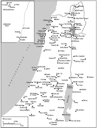 Archaeological sites in Ereẓ Israel. (See inset for area south of Dead Sea.)