Geography of Israel: Hula Valley
The Hula Valley, an agricultural region in northern Israel with abundant fresh water, affords an example of the delicate balance between nature and human development. The past 150 years of human settlement in the valley has been a continuous attempt to impose order upon nature. The drainage of Lake Hula and its surrounding swamps in the 1950s was the epitome of the attempts to alter the environment to suit human needs. Though initially perceived as a great national achievement for the fledgling State of Israel, with time it became evident that the benefits from transforming a "wasteland," Lake Hula and its swamps, into an agricultural "blessing" were limited. Today, after nearly 50 years of largely unsuccessful struggle to utilize the drained valley’s resources, the State of Israel has finally recognized that successful development can endure only if a balanced compromise between nature and development is achieved. Consequently, a small section of the former lake and swamp region was recently reflooded in an attempt to prevent further soil deterioration and to revive the spirit of an extinct ecosystem.
In this article, we provide an overview of human activity in the Hula Valley, focusing on exploitation of the valley’s natural resources. As aquatic scientists keenly aware of contemporary environmental issues, we hope to highlight the conflicting demands between social and economic development and environmental protection and conservation. We also hope to illustrate the vital role that scientists can have in resolving such a conflict.
The Geology and Geography of the Hula Valley
The Hula Valley lies within the northern part of the Dead Sea Rift Valley (Afro-Syrian Series) at an elevation of about 70 metres above mean sea level. Thousands of metres of land subsidence during the formation of the Rift Valley about a million years ago are still evident in the steep slopes of the Golan Heights to the east and the Upper Galilee mountains to the west, rising 400-900 metres above sea level. Basaltic hills of about 200 metres above sea level along the line Korazim–Rosh Pina–Gadot and originating from late Pleistocene volcanic activity define the southern border of the valley. Where these hills intercept the Jordan River, they are commonly referred to as the basalt "plug" because they restrict water drainage downstream into the Sea of Galilee (Lake Kinneret),* thereby forming the historic Lake Hula and its surrounding wetlands. In the north, the valley is delimited by a more gradual transition to the elevated Lebanon Valley, also rising to about 200 metres above sea level. As such, the Hula Valley is clearly defined, covering an area of 177 square kilometres (25 kilometres long by 6-8 kilometres wide).
The composition of the sediments accumulated on the valley floor provides a glimpse into the geological history of the region’s climatic fluctuations. Lacustrine sediments rich in lime indicate that a fresh water lake existed at times, expanding in size and depth during wetter periods. Drier periods led to the formations of swamps, during which peat, rich in organic matter, was deposited. The most recent lake, the historic Lake Hula, was formed about 20,000 years ago. During at least 14,000 years prior to the formation of Lake Hula the valley was swampland.
The climate of the Hula Valley today is Mediterranean, with hot dry summers and cool rainy winters. However, unlike the moderate Mediterranean climate of the coastal plains, the mountain-enclosed topography of the Hula Valley leads to more extreme seasonal, as well as daily, temperature fluctuations. Annual rainfull varies greatly between different parts of the valley and ranges from about 400 millimetres in the south, to up to 800 millimetres in the north. More than 1,500 millimetres of precipitation falls on the Herman mountain range (mostly in the form of snow), feeding underground springs, including the sources of the Jordan River, and giving rise to much of the abundant water flowing through the valley. The wind regime is dominated by regional patterns in the winter, with occasional strong north-easterly wind storms (Sharkiyah in Arabic). In summer, local warming and cooling patterns produce strong westerly to northerly winds in the afternoons.
Lake Hula and the Swamps
With its long history of human settlement, it is not surprising that Lake Hula (or Huleh) was referred to by different names. In the 14th century BCE, the Egyptians called the lake Samchuna. In the 1st century CE, the Jewish historian Flavius Josephus termed it Semechonitis, while in Aramaic the lake was called Hulata or Ulata. Yam Sumchi is used in Talmudic literature. More recently, the lake was called Buheirat el Huleh in Arabic and Agam Hula in Hebrew. The Waters of Merom has sometimes been used – erroneously – in scientific literature, although that term refers specifically to springs on the western side of the valley.
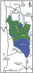
Prior to its drainage in the 1950s, Lake Hula was 5.3 kilometres long and 4.4 kilometres wide, extending over 12-14 square kilometres. It was a shallow, pear-shaped basin about one and a half metres deep in summer and three metres deep in winter. The area north of the lake was covered by peat swamps with dense stands of papyrus. Open-water ponds covered with yellow water-lilies occurred in deeper depressions within this papyrus "jungle." Further to the north, in areas that were water-logged in winter but dry in summer, was a zone of swampy meadows covered with grasses. A belt of reeds, mostly restricted to mineral soils, encompassed most of the lake and swamps. Altogether, the lake and swamps covered up to 60 square kilometres, with large seasonal and inter-annual variations due to changes in water level.
About two thirds of the water flowing into Lake Hula came from the Jordan River. The three sources of the Jordan, the Dan, Hazbani and Banias Rivers, originating on Mount Hermon, converged in the flat centre of the Hula Valley to form the Jordan River. Prior to the draining of the Hula, the Jordan split again into three main deltaic branches before entering the swamps. The stronger and perennial western branch, the Jordan itself, crossed the swamps and emptied into the lake. The two eastern branches, Tura and Az- Zawiya, had only winter flow and disappeared in the swamps. Other streams from the Golan Heights, the eastern Galilee mountains and from approximately 70 springs in the Hula Valley itself also fed the lake and swamps. From the lake’s outlet the Jordan River* bisected the basaltic "plug," flowing another 18 kilometres through the Jordan Canyon before emptying into the Kinneret.
Lake Hula was characterized by its tranquillity. Dense strands of emergent, submerged and floating aquatic vegetation covering the lake’s surface and bottom provided lush habitats for a diverse variety of animal life. The lake extended into the swamps, adjacent springs and streams, creating an even greater diversity of inter-connected aquatic niches. This habitat diversity supported the floral and faunal richness of the old Hula, and rendered it a key feeding station for migratory birds on their route between Europe and Africa. According to the researcher Ch. Dimentman and co-authors, Lake Hula probably contained the richest diversity of aquatic biota in the Levant, south of Lake Amiq in Turkey, which was also drained at about the same time as the Hula. Based on an extensive literature review and an examination of archived samples, they listed 260 species of insects, 95 crustaceans, 30 snails and clams, 21 fishes, seven amphibians and reptiles, 131 birds and three mammals.
Human Settlement and Development
The natural setting of the Hula, with ample water, abundant fish, waterfowl and other wildlife, as well as rich terrestrial and plant resources on its flanks, attracted human settlement from early prehistoric times. As such, it is not surprising that archaeological remains near the B’not Ya’akov ("Daughters of Jacob") bridge at the southern end of the valley date as early as the Paleolithic, and remnants of one of the first permanent settlements, Enan (Mallaha), dating from 9,000-10,000 years ago were discovered in the valley.
During early historical times, the Hula Valley was a main junction on the important trade route connecting the large commercial centre of Damascus with the eastern Mediterranean coast and Egypt. The Bronze Age cities of Hazor and Layish were built at key locations on this route approximately 4,000 years ago. Toward the end of the 13th century BCE, the Israelite tribe of Dan destroyed the city of Layish and built in its place a new city which they named Dan. This marked the beginning of about 400 years of Israelite rule over the Hula Valley, which ended when the valley was captured by the Assyrian armies of Tiglath Pileser III and its inhabitants were driven away.
Agriculture in the Hula Valley was always dependent on the effective use and control of water resources. Farming communities which mastered the use of irrigation endured, but unsuitable irrigation methods led to the proliferation of mosquitoes and malaria. It is uncertain when malaria first appeared in the Hula Valley, and its extent and impact varied with irrigation and drainage practices.
Throughout the Hellenistic, Roman, Byzantine and early Arab periods (fourth century bce to eighth centuries CE) rural settlement in the Hula Valley was uninterrupted. Literary sources testify to dense and prosperous settlement at the time of the Crusades. Traditional crops were rice (as early as the Hellenistic period), cotton and sugar cane (starting after the Arab conquest in 636), sorghum and maize. Water buffalo were introduced in the eighth century or earlier and raised on the rich pasture lands as an alternative cattle species, supplying milk and serving as beasts of burden.
During the 14th-19th centuries, there were no permanent settlements in the valley, though Bedouin shepherds continued to graze their flocks in the pasture lands. The cessation of settlement has been traced to the Mameluk invasion at the end of the 13th century and the building of the B’not Ya’akov Bridge in about 1260. The basalt arches of the bridge narrowed the bed of the Jordan River so that Lake Hula rose higher in winter and the swamps expanded northwards almost to the edge of the valley.
Settlement resumed between 1830 and 1840 primarily by run-away slaves, deserters from the Egyptian army, and other refugees. These Arab settlers are collectively referred to as Ghawarna. They subsisted primarily from the local assets of the swamps, building their houses from papyrus and earning income from reed-based crafts such as mat-making. They practiced primitive agriculture based on water buffalo husbandry and cultivation of rice, wheat and maize. The Ghawarna suffered severely from malaria, but many of them, especially those of African origin, had a genetic resistance to the disease. Still, mortality rates were high and nearly all newborn children died in infancy. Nevertheless, a population of not more than 3,000-4,000 people was maintained by a constant influx of newcomers. During the British Mandate (1918-1948), anti-malarial measures such as planned drainage led to improved living conditions and by 1936, the Ghawarna population had increased to nearly 12,000 persons.
The first modern Jewish settlement in the Hula Valley, Yesod Hama’ala on the western shore of the lake, was established in 1883 during the first aliya (wave of Jewish immigration and settlement) to Palestine.* Malaria hit this village hard, and no additional Jewish settlements were established in the valley for more than 50 years. A second wave of Jewish settlement in the valley started in 1939. Initially, these settlements also suffered heavily from malaria, but improvements in agricultural practices and the use of pesticides such as DDT reduced the infection rate among the Jewish settlers to below one percent. In total, by 1948 there were 12 Jewish and 23 Arab settlements in the Hula Valley. Following the etablishment of the State of Israel and during the 1948 War of Independence, the Arab inhabitants left the valley, moving to neighbouring Arab countries.
The Hula Drainage Project
The concept of draining the lake and swamps of the Hula Valley so as to increase the amount of arable and grazeable land and eradicate malaria, extends back to the 19th century. John MacGregor, a Scottish traveller to the Hula Valey in the 1860s, commented in his notes that in his opinion, the entire lake and swamps could be drained in one year by digging a 400-yard-long, 20 feet-deep canal at the outlet.
Attempts to drain the swamps were made by the Ghawarna in the late 1800s, by enlarging the outlet and by digging drainage canals. The extent of their operations and their effectiveness is uncertain. Soon afterwards, the valley became the property of the Turkish Sultan Abed el-Hamid. His administration planned to drain the swamps in order to gain profits from agriculture. However, after several failed attempts they turned the task into a concession for private companies. The concession was sold initially to Syrian merchants. After many years of dealings and bargaining, the drainage concession was purchased by the British Palestine Land Development Company in 1934. But due to the outbreak of political disturbances in 1936 and economic difficulties during World War II the Hula draining project materialized only after the State of Israel was established in 1948.
The declared objectives of the Hula draining project were two-fold: the addition of arable land and the eradication of malaria. Additional perceived benefits were to be an increase in the water potential of the newly established state by reducing evaporation losses, and utilization of peat as fertilizer and for industry.
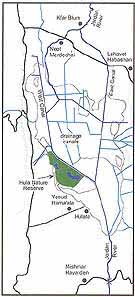
The draining operations, carried out by the Jewish National Fund (JNF), the agency responsible for land development in Israel, began in 1951 and were completed by 1958. The draining was achieved by two main engineering operations. The Jordan River downstream of the lake was deepened and widened, especially at the basalt plug, to allow the outflow of larger quantities of water. In the swamp region north of the lake, the Jordan was diverted into two newly-dug peripheral canals, the East Canal and the West Canal, which enclosed most of the peat lands. These canals converged near the centre of the former lake and then followed the original but now deepened course of the Jordan, continuing southward to Lake Kinneret. Consequently, the section of the Jordan going through the centre of the drained valley as well as other waters flowing through the valley were channeled through a dense network of secondary drainage and irrigation canals to the East and West Canals. In the years following the completion of the drainage project, sewage from the growing town of Kiryat Shmona was also directed into the West Canal.
Public interest associated with the draining project was so great that the digging sites at the Hula Valley became major tourist attractions. In fact, it was necessary to restrict tourism in order to prevent delays in the progress of the work. At the same time, concern was already voiced by scientists and naturalists who opposed the project because they viewed the swamps as an ecological treasure that must be preserved for future generations. As a result, a small (350 hectare) area of papyrus swampland in the southwest of the valley was set aside and in 1963, became Israel’s first nature reserve.
Perhaps the greatest benefit of the debate over the draining of the Hula was the establishment of Israel’s most prominent environmental institutions: the Society for Protection of Nature, and a few years later the Nature Reserves Authority.
The Dry Hula Valley (1958-1993)
Given the conditions and knowledge existing at the time, the drainage of the lake and swamps of the Hula seemed fully justified. Not only did it provide solutions to urgent needs of the young state, it was also considered a great engineering achievement and followed common practice worldwide. Moreover, the increase in cultivable land and the eradication of malaria were rooted in Zionist philosophy. During the 1950s, prior to the construction of the National Water Carrier, food was scarce in Israel and currency for its import was lacking. The additional 5,000 hectares of arable land in the Hula Valley proved to be highly beneficial to the economic development of the country.
However, as the years went by, it became clear that the objectives of the draining project had been only partially fulfilled. The peat soils proved suitable for agriculture, but the anticipated exceptional yields were never obtained. The goal of eradication of malaria was actually achieved in 1949, irrespective of the draining project, as a by-product of the exodus of carriers of the malarial parasite. Nevertheless the project succeeded in removing 5,000 hectares of anopheles mosquito habitat thereby reducing the chances for re-introduction of the disease. The use of peat as fertilizer or for industry never materialized. Probably the main benefit of the project was the addition of an estimated 28 million cubic metres of water per year to the country’s water potential through reduction of loss by evaporation.
With time, severe problems developed in the middle and southern parts of the Hula Valley, most of which originated from peat sediment degradation and subsidence. As the level of the groundwater table fell, air penetrated into the dried peat enhancing microbial decomposition of organic matter. Often these processes led to uncontrollable underground fires and the formation of dangerous caverns within the peat. The weathered peat soils turned into infertile black dust. Strong winds sweeping the valley produced dust storms that caused major damage to agricultural crops. Consequently, the ground surface subsided by up to three metres in some regions and inundation of these areas during winter rains restricted cultivation in many areas. An indirect problem associated with the drying of the soils was the proliferation of field mice populations which soared and wreaked havoc on agricultural crops in the valley. Over time, farmers abandoned more and more of the valley where cultivation was no longer profitable, thereby further enhancing the rate at which these soils deteriorated.
In addition to these agricultural problems, various ecological problems became apparent. The decomposing peat released large amounts of nitrates and sulfates which during the winter rainy season were washed into Lake Kinneret. Although the impact of sulfates on the Kinneret is less obvious, nitrates are major sources of the nitrogen required for algal growth and their addition to water can lead to reduced water quality. Estimates are that about 40 per cent of all nitrate loading into Lake Kinneret comes from the drained Hula Valley.*
Furthermore, even though the Hula Nature Reserve was created to preserve much of the character and nature of the original lake and swamps, after the draining, 119 animal species were lost to the region, of which 37 were totally lost from Israel. Similarly, many freshwater plant species became extinct and many of the massive flocks of migratory birds that used to land in the valley found alternative feeding sites on their route between Europe and Africa.
In the 1980s it became apparent that action had to be taken to stop the deterioration of conditions in the Hula Valley. Consequently, the Hula Restoration Project was formulated.
The Hula Restoration Project
From the beginning it was clear that a successful rehabilitation programme for the Hula would require careful planning based on the best possible expertise in many disciplines, including soil sciences, agriculture, hydrology, ecology and tourism. Again the JNF stepped in as the driving force, and a scientific overseeing committee was appointed to review the relevant issues of the project. The committee identified two national goals for a rehabilitation programme: 1) preservation of the peat soils for future generations, and 2) protection of Lake Kinneret from contamination originating from the Hula peat.
A feasibility survey was completed by 1990, examining alternative ways for achieving these national goals in the framework of a rehabilitation plan that would also address nature conservation and water supply issues. In addition, because the rehabilitation plan would require the giving up of land by the farming communities in the area, it had to include a means of alternative income to the farmers. Therefore a compromise plan was chosen which would provide alternative income in the form of eco-tourism. The project commenced in 1993, with joint funding by the Israeli government (67 percent) and the JNF (33 percent). As of June 1996, more than US $23 million had been invested.
The three main principles of the Hula Restoration Project are:
1. Maintenance of a high water table and year-round green cover on the peat soils in order to slow down the decomposition and subsidence processes;
2. Creation of a small shallow lake rich in plant, fish and bird life and surrounded by green pastures with grazing safari animals to serve as a centre for tourism and recreation;
3. Minimization of the flow of pollutants into Lake Kinneret from both the communities of the Hula Valley and from the peat soils.
To reduce soil deterioration, soil and agricultural scientists have devised a crop rotation scheme which offers a compromise between income and soil protection. In the areas unsuitable for cultivation, current research results indicate that local vegetation in conjunction with imported tropical grasses could provide the desired year-round green cover of the peat soils, as well as providing grazing lands for safari animals.
In order to keep the peat soils wet, hydrologists drafted plans to raise the water table to an average of 75 centimetres below the surface. The height of the water table was determined so as to be deep enough to allow cultivation of the land allocated for agriculture, but shallow enough to reduce the volume of peat requiring constant irrigation. The high water table would be regulated primarily via an extensive network of 90 kilometres of new drainage/flood canals, a small lake and large-scale surface irrigation equipment.
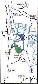
In addition to providing increased flexibility in water level management, the lake was designed to serve as a centre for developing eco-tourism and recreation. This small lake, named Lake Agmon,* was dug in the area of the peat lands least suitable for agriculture and flooded in April-May, 1994. The historic, but dried-up route of the Jordan River, through the centre of the valley, was restored and forms the primary source of water for the lake. By creating these two aquatic systems, the planners hoped to create suitable conditions for the re-establishment of some of the many plant and animal species that had been lost to the region, thus attracting tourists. Justifiably, the concept of tourist development caused concern among those interested in ecological priorities, principally the Nature Reserves Authority and the Society for the Protection of Nature in Israel. While the environmental organizations acknowledged that the area could not be totally insulated as a formal nature reserve, they were able to convince the farmers and developers that the commercial elements had to be integrated aesthetically into the new landscape. The agreed plan called for building a holiday village northwest of the lake. This centre would also offer sites for bird watching, hiking, picknicking, and boating.
Several actions were taken to minimize the flow of polluted water from the Hula Valley into Lake Kinneret. First, pumping stations and regulation facilities were constructed to prevent overflows from the peat lands into the Jordan. Instead, these waters are diverted into Lake Agmon via a northern inlet canal. Water flowing out of Lake Agmon is diverted into a large storage basin, the Einan Reservoir, west of the valley, to be used for irrigation in adjacent farmlands. Second, an underground partition was constructed, sectioning the valley south of Lake Agmon from east to west, to prevent underground seepage of peat water southward. Thirdly, there is a pipeline to carry sewage effluents from the town of Kiryat Shmona and other communities in the valley, directly to the Einan Reservoir. As with the waters flowing through the Hula peat soils, these polluted waters will be treated and used for irrigation and will not reach Lake Kinneret.
Before 1951 |
| 1951-1958 |
| After 1994 |
Lake Agmon
Lake Agmon is located in the southern part of the Hula Valley in the area that once served as the transition between Lake Hula and the surrounding swamps. It is important to note that this new lake was not intended to be a re-creation of Lake Hula. It is shallower and much smaller than the original lake. It has an irregular shape, covering an area of one square kilometre with mostly less than one metre depth of water. Deeper (one and a half metre) boat canals were dug along its rims and surrounding two islands on the northeast side, to allow limited boating activity. Several smaller islands were created in the middle of the lake, to provide protected nesting sites for birds.
The quality of water in Lake Agmon is strongly influenced by the two primary water sources – the Jordan River entering the lake from the northwest and bringing relatively clean, high-quality water, and a central drainage canal flowing into the lake from the north, bringing poorer-quality peat drainage waters. Even though the Jordan is the primary source of water during much of the year, the water quality in the lake is more characteristic of peat drainage waters, often highly coloured and cloudy with high levels of dissolved substances such as sulfates, carbonates and plant nutrients. Although rendering the water unsuitable for drinking, these substances contribute to the vitality of the ecosystem. The combination of abundant plant nutrients, diverse aquatic habitats and sunlight leads to enhanced growth of many forms of plant life. These include microscopic free-floating algae (phytoplankton), mats of filamentous algae covering the lake sediments, rooted plants emerging through the water, such as papyrus and cattail, and rooted submerged or floating vascular plants. The high primary production supports a healthy food web of zooplankton (microscopic grazing and predatory animals), insects, molluscs, fish, birds and other animals.
An important attribute for the eco-tourism aspects of the project has been the successful re-introduction of plant species that had beome extinct following the drying of Lake Hula. Of ten such plant species that were selected for re-introduction, five successfully established populations within two years and two more showed potential to survive. In addition, more than 30 aquatic plant species have re-established themselves spontaneously. Near the shores of the lake an additional 15-20 species have re-invaded the valley.
Much of the success in species re-establishment in the area may be attributed to high nutrient availability, which also gives rise to extensive plant development on the shorelines and in the lake. These dense stands of plants in Lake Agmon are aesthetically pleasing and attract abundant bird populations and other wildlife. However, in the drainage/flood canals, dense strands of plant growth impede water movement, thereby reducing the effectiveness and flexibility of the management of the water table elevation. Moreover, the slow backwater conditions in these canals with heavy vegetation raise the problem of a possible return of malaria. Neverthless, recent surveys suggest that the particular species of anopheles mosquito responsible for the spread of malaria remains rare and the threat of malaria in the Hula Valley is no higher than in other parts of Israel.
During the first three years after re-flooding, at least 120 species of birds have been recorded in or around the lake. Massive flocks of migratory pelicans, storks, cormorants, cranes, and other birds en route between Europe and Africa, spend days to weeks in the vicinity of Lake Agmon. Also, new nesting colonies of various species such as herons have been established. Birds are attracted not only by the lush nesting sites, but also by the rich food resources in the lake. Following the draining of the original Hula, many of these birds were quick to discover commercial fish ponds as an alternative source of food in the valley, causing extensive economic losses. For this reason, the managers of the Hula Restoration Project are not taking any chances. Fearing the new lake may not support enough fish production to draw birds away from the fish ponds, the natural fish populations are supplemented by artificial stocking. Unfortunately, not all aspects of the returning bird populations are positive. An unforeseen complication is that many of the species attracted to the lake for nesting or other reasons, such as coots and cranes, cause extensive damage to agriculture in nearby fields.
Though still in research and planning stages, the Hula Restoration Project also intends to populate the areas around the lake with grazing mammals. The water buffalo is an obvious choice due to its history in the area and because a small population is already present in the Hula Nature Reserve. Other animals, such as donkeys, or swamp horses from France, were also considered. The project has recognized that not only will sufficient grazing areas be required, but these animals will also need shade from the strong summer sun. For this reason, intense efforts are underway to decide on appropriate shade trees that can be introduced into the area. Unfortunately, the peat soils are unstable, so that most tree species would be uprooted by the strong winds common in the valley. Researchers are hoping that by planting trees in large holes filled with lacustrine soils from the bed of the reconstructed Jordan River, the trees will be better able to tolerate the winds.
Lake Agmon is an aesthetically pleasing site with relatively good water quality. As yet this is still a developing environment and major changes in community composition and structure of its animal and plant life may still take place. Within the first four years since its formation, the lake has shown signs of a healthy ecosystem that attracts visitors (both human and wildlife) year round. In 1998, the diversion of the Hula peat waters and Kiryat Shmona sewage through the Einan Reservoir was completed, and now we anticipate that, indeed, the flow of nitrates into Lake Kinneret will be reduced by at least 40 per cent annually and pollution of the Kinneret in general will be lowered.
Similar to the emotional reactions of those who expected an agricultural paradise in the Hula Valley following drainage of the swamps in the 1950s, today we have the feeling that the restoration project has been remarkably successful. A beautiful lake with lush vegetation, green fields and flocks of birds dazzle the eye and offer a picturesque scene of tranquillity against the grandeur of Mount Hermon.
It is perhaps ironic that this project has instigated a conflict with several environmental organizations over the planned development of tourism. Granted, a return to the Hula of yesteryear would be a conservationist’s dream. However, we must be reminded that dreams are usually not practical. Therefore it may be beneficial for the environmentally concerned to try to find a positive side to touristic development, such as the opportunity to increase national awareness of the environment. We should applaud the communities of the valley and the Hula project for bringing back a small fragment of an extinct ecosystem.
Acknowledgements
We have drawn material for this article from the published Hebrew and English literature and from professional reports. Especially useful were the writings of Y. Avnimelech, S. Dasberg, A. Harpaz, A. Horowitz, D. Kaplan, Y. Karmon, D. Levanon, M. Livneh, G. Orshan, G. Shacham, E. Shy and M. Zohary, and the monographs on the Hula Valley by Ch. Dimentman, H. Bromli and F.D.Por.
Much of the present-day material relating to the Hula Restoration Project and Lake Agmon is based on our work as coordinators of the Hula Aquatic Research Programme which accompanies the restoration project, as well as on other research programmes within the project. For this, we are greatly indebted to our many colleagues. Lastly, we thank T. Berman, D. Kaplan and D. Zohary for providing useful comments and suggestions.
*In the present article, we have used the common Israeli term – Kinneret – for the Sea of Galilee. The word comes from the Hebrew word kinor (lyre or harp), roughly describing the shape of the lake.
* See Eli Choter: "The River Jordan," Ariel no 89, 1992.
* See Arik Lubovsky: "The Subotniks of Yesod Hama’ala," Ariel no. 90, 1992.
* See Tom Berman: "The Kinneret – Sea of Galilee," Ariel no 98, 1994.
* From the Hebrew word for "bullrush."
Sources: Israeli Foreign Ministry
Download our mobile app for on-the-go access to the Jewish Virtual Library