History & Overview
Treblinka was designed as a Nazi extermination camp in occupied Poland during World War II. The camp, constructed as part of Operation Reinhard, operated between July 1942 and October 1943 during which time approximately 850,000 men, women and children were murdered, including more than 800,000 Jews.
Before its liberation by the Allies, the retreating German army liquidated the camp and destroyed whatever evidence remained of the atrocities committed within its fences. For many decades, the only evidence of the horrors that took place at Treblinka came from testimonies of Nazi SS-men stationed there as well a few Jewish survivors who were willing to share their stories, but in 2012 forensic archaeologists uncovered previously hidden mass graves at the site that help prove its term as an extermination camp.
Samuel Willenberg, the last of only 67 survivors of the Treblinka extermination camp, passed away in Israel on February 21, 2016, at the age of 93. Willenberg was brought to Treblinka in 1942 at age 19, and survived because he was strong and told the gaurds that he was a builder. Allegedly, he was the only individual on his transport that was not sent to the gas chambers immediately upon arrival. He escaped Treblinka on August 2, 1943 along with 300 others, and survived the massive SS manhunt that recaptured 200 escapees despite being shot in the leg. Following his escape Willenberg returned to Warsaw, Poland, and after finding his father living in hiding outside of the ghetto, he joined the underground resistance and took part in the Warsaw Uprising.
- What Was Treblinka?
- Approaching
the Treblinka Camp
- The Entrance
to the Treblinka
- Treblinka Memorial
Stones
- Stone Sculptures
at Treblinka
- Symbolic Cemetery
at Treblinka
- Stone Honoring Janusz
Korczak
- Warsaw Stone
- Uncovered Mass Graves Site
What was Treblinka?
For the first 20 to 25 years after World War II, the
survivors of the Holocaust mostly kept
silent about their horrendous experiences in the concentration
camps. In those years, the only Nazi concentration camp names that
were familiar to most Americans were Dachau, Buchenwald and Bergen-Belsen,
the places that were shown in the newsreels in movie theaters following
their liberation by American
and British troops. Who could ever forget the sight of the naked, emaciated
bodies being shoved into mass graves with a bulldozer at Bergen-Belsen?
Or Margaret Bourke-White's shocking photographs of the survivors of
Buchenwald?
Back then, few people in America had ever heard of Treblinka, a camp
hidden in the remote forests of northeastern Poland,
along the western border of the Bialystok province. Most Americans believed, up until the mid 1970s, that the
majority of the 6 million Jews, who were victims of the Holocaust, had
died in the gas chambers at the Dachau camp near Munich, Germany. The only camp mentioned in
the 1970s movie "Judgment at Nuremberg" was Dachau.
Now it is known that Dachau and Buchenwald, although
horrible places where many people died, were concentration camps (Konzentrationslager),
not extermination centers (Vernichtungslager) designed for the
express purpose of annihilating all the Jews of Europe. Bergen-Belsen,
the most horrible camp of them all, was called an internment camp for
prisoner exchange (Aufenthaltslager) and later became a sick
camp (Krankenlager) where concentration camp prisoners who were
no longer able to work were sent.
According to Raul Hilberg in his book The
Destruction of the European Jews, there were six extermination
centers, all of them in Poland, including the little-known camp at Treblinka.
The other extermination camps were at Belzec, Sobibor, Chelmno, Majdanek and Auschwitz-Birkenau,
all in Russian-liberated Poland. The last two also functioned as forced
labor camps (Zwangsarbeitslager), and were still operational
when liberated by Russian soldiers towards the end of the war in 1944
and early 1945. The camps at Treblinka, Belzec, Sobibor and Chelmno
had already been liquidated by the Germans before the Russians arrived,
and there was no remaining evidence of the Nazi atrocities.
An information pamphlet available at the entrance
to the former camp site at Treblinka says, "In a relatively
short time of its existence the camp took a total of over 800,000
victims of Jews from Poland, Austria, Belgium, Czechoslovakia,
France, Greece, Jugoslavia, Germany and the Soviet Union."
From Warsaw, the route
to Treblinka starts with the crossing of the river Vistula, then a turn
onto Highway 18 northeast towards Bialystok, the only large town in
the Bialystok province, which is the most remote northeast corner of
Poland. It is in the Bialystok province that bison still roam, and one
can see the last remaining primeval forest and wetlands on the European
continent. This area could truly be called the "Wild East"
of Poland.
Treblinka is near the Bug River which, during World
War II, formed the border between the Nazi occupied General
Government of Poland and the zone occupied by the Russians from
September 1939 until the German invasion of Russia in June 1941.
Highway 18 is a two-lane concrete road with
pedestrian paths on each side. There is heavy traffic of trucks
from Belarus (Byelorussia or White Russia) and Estonia traveling
west into Poland; traffic is slowed down by local Polish farmers
driving wagons pulled by tractors or by a lone horse. The terrain
is completely flat with farm land on each side of the road but
not a fence in sight. Then the road goes through mile after mile
of dense forest. During the war these woods were full of Polish
and Jewish partisans, who hid there along with escaped Russian
Prisoners of War, and fought the Nazis by blowing up bridges
and train tracks or placing land mines to kill columns of German
soldiers.
At a point 22 kilometers from Treblinka, the
route turns southeast off of Highway 18. This new road is a one-lane
blacktop with no space on the sides for pedestrians. The road
gets progressively worse until the final leg of the journey is
pockmarked with pot holes.
The Treblinka camp got its name from the tiny
village of Treblinka, the closest town to Malkinia railroad junction,
from where trains, carrying thousands of Jews crammed into freight
cars, were shunted onto a sidetrack which the Nazis extended
to the extermination camp. However, the closest inhabited place
on the road to the camp is the equally tiny hamlet of Poniatowa.
The road as it nears the
camp becomes a one-lane blacktop, badly in need of repair.
During the Nazi occupation of Poland
there was a forced labor camp at Poniatowa; in November 1943
the Jewish prisoners there were shot after prison revolts and
mass escapes at the Treblinka and Sobibor camps alarmed the Nazis.
The village of Treblinka is now almost deserted
and the buildings are far more dilapidated than those in Poniatowa.
Some of its
rural dwellings are so humble that you would not suspect that
people still live there if it were not for the lace curtains
which are always hung in the windows of these cottages.
Approaching the
Treblinka Camp
As you get near the village of Treblinka, there is a
line of beautiful chestnut trees alongside the road on the right. You
see old men walking along the road, carrying bundles of sticks on their
backs. There are farm families digging potatoes and burning the dried
potato vines in the fields. Occasionally, you see a stork's nest on
a roof near the chimney, or a large ant hill at the edge of a forest,
surrounded by a tiny log fence for protection. There are old wooden
Catholic churches and white cottages with thatched roofs along
the road. Telephone poles are topped with glass insulators, the kind
you see for sale in antique stores in America. The farther you travel
down this road, the farther you seem to go back in time.
Near Malkinia Junction, the road now has ancient
concrete barriers to prevent cars from leaving the road, and
quaint old railroad crossing signs. From this junction, a branch
line runs south from the Ostbahn (Eastern Railroad line) to the
village of Treblinka.
 Entrance to Treblinka camp, from inside
the camp
Entrance to Treblinka camp, from inside
the camp |
Finally you get to a narrow archway over the road, the
purpose of which is to keep vehicles larger than 2.5 tons from proceeding
beyond this point. Just before you get to the camp, you must cross a
one-lane railroad bridge that was formerly used by both trains and cars,
but is now used only by cars and pedestrians. According to Martin Gilbert
in his book Holocaust
Journey, this bridge was rebuilt some time after 1959, after
it was destroyed during World War II.
The surface of the bridge is made of wood
and the train tracks are not level, which would cause any train
using the bridge to list to one side. The tracks of the railroad
lines in Germany and Poland were then, and still are today, a
different width than the tracks across the eastern border of
the Bialystok District in what used to be the Soviet Union, and
is now the country of Byelorussia, formerly called White Russia.
According to my tour guide, today trains from Germany or Poland
must stop at the Bialystok eastern border and change to wider
wheels which can run on the tracks in Russia. In 1941, it was
necessary for the German invading army to extend the Polish gauge
tracks into Russia, as they advanced. The poor condition of the
roads in Poland and Russia hampered the advancing Germany troops
when their vehicles would become mired in three feet of mud.
Three kilometers from Treblinka was located the main railroad
line into Russia, through the Bialystok province.
After the joint conquest of Poland by the
Germans and the Russians in September 1939, the river Bug (pronounced
Boog) became the border between the German section and the Russian
section of occupied Poland; then the Nazis invaded the Soviet
Union in June 1941 and conquered the strip of eastern Poland
that was formerly occupied by the Russians. Treblinka was in
the former Russian section, but by 1942 it was occupied by the
Nazis, who were then in a position to put their plan to exterminate
the Jews into effect. The other two Operation Reinhard extermination
camps (Sobibor and Belzec) were also located along the Bug river
border, south of Treblinka.
 Memorial stone at entrance to Treblinka
 |
Hardly more than a creek, the Bug is shallow
enough in some places so that one can wade across it, and according
to historian Martin Gilbert, some refugees, from both sides,
did wade across. The movie "Europa, Europa" has a scene
in which Jewish refugees are shown walking toward the Russian
sector, trying to escape the Nazis in September 1939 by crossing
the Bug river on rafts.
The pictures above show the archway, the bridge
and the river, taken on the return trip from Treblinka.
The Entrance to the Treblinka
Extermination Camp
When you finally arrive at the entrance to
the site of the former Treblinka extermination camp, you are
on what looks like an old logging road, which goes through another
dense forest. If you had wandered into this area by mistake,
you might think that you had just entered a campground in a national
forest. Everything is quiet and serene with only the sound of
a few birds.
The caretaker's house is on the right as you enter, and
there is a small wooden building with a sign on it which says Bistro.
After my visit to the camp, I stopped there for a cup of tea, but the
place was closed. Just beyond the Bistro is a narrow parking lot and
a small building where you can buy postcards or a three-page pamphlet
printed in several languages.
 Line of stones marks boundary line of Treblinka
 |
There is a covered arcade area open to
the elements in front of the building, where huge blowups of several
famous Holocaust pictures are hung, along with a poster with some information
about Janusz Korczak,
a Jewish director of an orphanage, who accompanied a group of orphans
to the Treblinka camp, and died along with them.
Treblinka Memorial Stones
According to a pamphlet which I purchased
at the camp tourist center, "The extermination camp in Treblinka
was built in the middle of 1942 near the already existing labour
camp. It was surrounded by fence and rows of barbed wire along
which there were watchtowers with machine guns every ten metres.
The main part of the camp constituted (sic) two buildings in
which there were 13 gas chambers altogether. Two thousand people
could be put to death at a time in them. Death by suffocation
with fumes came after 10 - 15 minutes. First the bodies of the
victims were buried, later were cremated on big grates out of
doors. The ashes were mixed witch (sic) sand and buried in one
spot."
According to Martin Gilbert in his book, Holocaust
Journey, the gas chambers at Treblinka utilized carbon monoxide
from diesel engines. Many writers say that these diesel engines were
obtained from captured Russian submarines, but according to the Nizkor
Project, they were large 500 BHP engines from captured Soviet T-34
tanks. At the Nuremberg trial of the Nazi war criminals, the American
government charged that the Jews were murdered at Treblinka in "steam
chambers," not gas chambers.
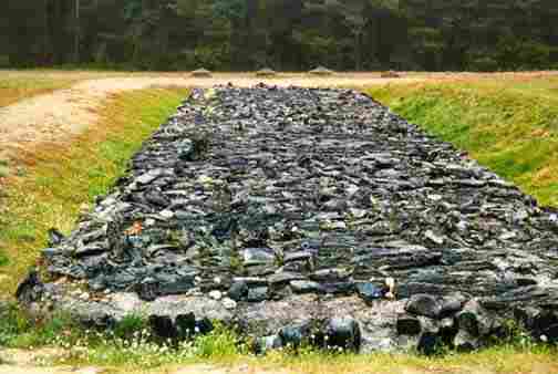
 Stones recreate railroad ties for the tracks
 |
The pamphlet continues with this information:
"Killing took place with great speed. The whole process
of killing the people, starting from thier (sic) arrival at the
camp railroad till removing the corpses from the gas chambers,
lasted about 2 hours. Treblinka was known among the Nazis as
an example of good organization of a death camp. It was a real
extermination centre."
There is a large memorial
stone at the entrance to the cobblestone path up to the virtual
cemetery. On the stone is a map showing the gravel pit in the
center with the labor camp to the left and the extermination
camp to the right. (On a real map, the gravel pit and labor camp
are located to the south of the extermination camp.)
Two stones placed at an angle to form a gate into the former
camp, and in the foreground 6 memorial stones, set close together,
which are located just beyond the stone with the map. Each of the six stones is inscribed
with a different language including Hebrew, English and Polish.
The inscription says that the camp was in operation from July
1942 to August 1943 and that during that time 800,000 Jews were
killed there. It also mentions the Aug. 2, 1943 uprising, calling
it the "armed revolt which was crashed (sic) in blood by
the Nazi hangmen." It was this uprising, along with those
at Sobibor and Warsaw, which motivated the Nazis to liquidate
the Jews of Lublin and Poniatowa in November 1943.
The pamphlet says that "After the riot
the camp was being slowly liquidated and in November of 1943
it was not existing already." By this time, the Germans
were losing the war on the Russian front and were in retreat.
The Treblinka camp was completely dismantled and destroyed when
it was liquidated. Among the few survivors were those who escaped
during the uprising and joined the partisans in the forests.
 Large stones mark railroad ties inside the camp
 |
Looking
toward the east, on the left side of the cobblestone path as
you enter, there is a line of stone markers which delineate the original
northern border of the camp. It is so quiet here that the only
sound is your own footsteps on the cobblestone path.
Stone Sculptures at Treblinka
According to Jewish historian Martin Gilbert, the Treblinka
camp was one of the three Operation
Reinhard camps organized by Odilo Globocnik in 1942, after the assassination
of Reinhard Heydrich in Prague, to carry out the Nazi plan for systematic extermination of
the Jews. Reinhard Heydrich was the man who led the conference on January
20, 1942 at Wannsee,
a suburb of Berlin, where the "Final
Solution" for Europe's 11 million Jews was planned. The protocols
from the conference used the expression "transportation to the
East" as a euphemism to mean the genocidal killing of all the European
Jews. The other two Operation Reinhard camps, Sobibor and Belzec, were also
located on the eastern border of Poland, to the south of Treblinka.
There were no "selections" made at the Operation Reinhard
camps, nor at Chelmno.
All three Operation Reinhard camps were located on major railroad lines
from Poland into Russia.
At this point in the war, the Nazis had penetrated
deep inside the Soviet Union, after first taking the lands in
eastern Poland which had been conquered by the Russians in Sept.
1939. Treblinka was located in the area of Poland which had been
occupied by the Soviet Union from Sept. 1939 until the German
invasion of Russia on June 22, 1941.
The railroad tracks go in a straight line
to Malkinia Junction from Warsaw and then branch off to Treblinka.
 Stones commemorate the victims
from
Poland & Czechoslovakia |
In 1942 new railroad tracks were built by the
Nazis, extending from the village of Treblinka into the extermination
camp. At the camp, a storehouse was "disguised as a train
station," according to the pamphlet available at the memorial
site.
After you pass through the two stones set
at an angle to form an entrance gate into the area where the
Treblinka camp once stood, you come upon an immense stone sculpture
designed to represent the railroad ties on which the tracks were
laid on the spur line that the Germans built from Treblinka into
the camp. The tracks begin in the wooded area outside the camp
boundary line and then make
a sharp turn to the left (eastward) into the camp.
Nearby is the end of the railroad spur
line with a stone platform to the left. When the camp was in operation,
there was a real train platform in this spot and behind it the storehouse,
disguised as a train depot, which contained the clothing and other items
which the victims had brought with them to the camp. Here lies a line of stones which represent the
10 different countries, including Greece,
Czechoslovakia, Poland, Bulgaria
and others, from which the Jews were transported by train to be exterminated
here in this remote, God-forsaken spot in the forest.
Symbolic Cemetery at Treblinka
Just south of the recreated stone train platform,
and in front of you as you are looking southward into the camp
with the platform on the left, is the location of the "burial
pits for those who died during transportation," according
to the camp pamphlet.
 Front of stone monument at Treblinka symbolic
graveyard
Front of stone monument at Treblinka symbolic
graveyard |
East of the burial pits, according to the
pamphlet, was an "execution site (disguised as a hospital)."
Farther east and half way up the gentle slope to where the symbolic
graveyard now stands, there were "3 old gas chambers"
according to the pamphlet, and a short distance to the north
of them were built "10 new gas chambers." According
to my tour guide, the first gas chambers used carbon monoxide,
but later some gas chambers were built which were disguised to
look like showers and used the insecticide known as Zyklon B
for gassing.
A short distance farther up the slope to the
east of the gas chambers was located the "cremation pyres"
according to a map in the camp pamphlet. None of the three Operation
Reinhard extermination camps, all of which were located on the
Polish border, had a crematorium for burning the bodies of the
dead. Of the other five extermination camps which were in operation
during the same period (Chelmno, Sobibor, Belzec, Majdanek and
Auschwitz-Birkenau), only Auschwitz-Birkenau and Majdanek, which
also functioned as forced labor camps, had crematoriums.
Inside the camp lie stones
commemorating the Jewish victims from Poland and Czechoslovakia. There
are a total of 10 such stones with names of countries on them. According
to Martin Gilbert in his book Holocaust
Journey, there were 13,000 Jews deported here from the Greek provinces of Macedonia and Thrace, which were then occupied by Bulgaria,
so their stone says "Bulgaria." (Bulgaria was an ally of Nazi
Germany, along with Rumania, Hungary,
Croatia, Slovakia, Finland, Italy, Austria, Lithuania, Estonia, and Latvia.) There
is another stone for the 43,000 Greek Jews who were brought here. At
the base of the stones, visitors have placed votive candles in metal
cans, fresh cut flowers and tiny flags of Israel.
A large granite memorial
stone, designed to resemble a Jewish tombstone, which according
to the camp pamphlet was built between 1959 and 1963. It is located
approximately on the spot where the gas chambers stood, according
to the tour guide. A Menorah sits at the top of the tombstone. The large crack down the
middle of the stone is part of the design. Surrounding the huge
tombstone are some of the 1,700 small stones which represent
the villages and towns from whence came the 800,000 victims of
this Nazi barbarity.
Stone Honoring Janusz Korczak
Located on a knoll at the top of a gentle
slope on the site of the former Treblinka extermination camp
is a large circular area with 1,700 stones of various sizes and
colors set into concrete, which represent a symbolic cemetery.
According to a pamphlet which I purchased at the camp reception
center, "The great monument in Treblinka is a homage of
the Polish people to those ashes lie under the concrete plates
of the symbolic cemetery. It is one of the most tragic monuments
of martyrdom in Poland."
My tour guide confirmed that the ashes of
the 800,000 people who died here were placed in this area and
are now hidden underneath the symbolic cemetery and by the grass
and tiny flowers which cover the spot. The map in the camp pamphlet
does not specify the exact spot where the ashes were buried.
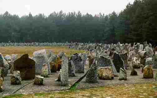 1,700 stones set in concrete in a circle at the
top of Treblinka
1,700 stones set in concrete in a circle at the
top of Treblinka |
The tour guide pointed out one of the 1,700 symbolic
stones which represents the city of Kielce in central Poland, where
42 Jews were killed by a mob of Polish citizens in a pogrom on July
4, 1946, long after the Nazi occupation had ended. Today Kielce is a modern industrial city with a population of 210,000, located between Warsaw and Krakow.
In 1939, the Jewish population was around 25,000, although until the
early 1800s, Jews were barred from living in the city. The 1946 pogrom
was the last in Poland; after that most of the 300,000 Polish Holocaust
survivors fled the country.
There is also a stone for Janusz
Korczak, the only person to have an individual stone in the symbolic
cemetery. Korczak was a pseudonym for Dr. Henryk Goldzmit. He was a
teacher and a social worker who ran an orphanage in Warsaw. He also
did a weekly radio show for children, and wrote a series of children's
books in which the central character was a boy king named King Matt.
In July 1942, he turned down the opportunity to escape from the ghetto,
and instead accompanied his orphans to Treblinka where he was murdered
along with them. According to the U.S. Holocaust Museum, Korczak marched
with his 192 orphans to the Umschlagplatz with one child carrying the
flag of King Matt with the Zionist flag on the other side of it.
Another stone represents the cremation pit
where, according to the camp pamphlet, bodies were burned on "grates."
The pamphlet calls "melted basalt"
set on a "concrete fundamental plate."Four round containers where "eternal flames"
can be lit on special occasions. The map in the camp pamphlet shows
that there were actually two cremation pyres, located just east of the
10 new gas chambers. The bodies which had been previously buried were
dug up and cremated on the orders of Heinrich
Himmler, after he visited the camp in 1943, according to Martin
Gilbert.
Stone honors Janusz Korczak (right) and memorial stones of basalt recreate pits where
bodies were burned (left)
|
|
Warsaw Stone
 Symbolic grave stone honors victims from
(Warsaw)
Symbolic grave stone honors victims from
(Warsaw) |
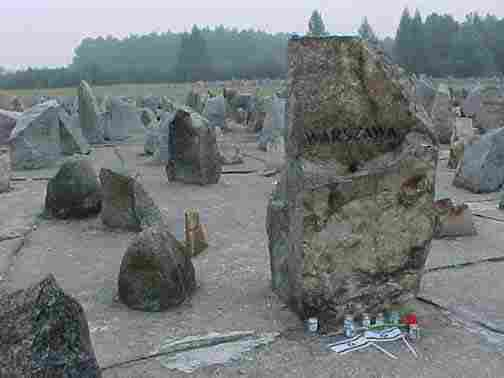
The largest stone at the symbolic cemetery is the one
for Warsaw, from where
the largest number of Jews were transported to Treblinka. According
to historian Martin Gilbert, there were 265,000 Jews from Warsaw deported
to Treblinka. In 1940 the Jewish population of Warsaw and the surrounding
area, about 400,000 people, were first crowded into a walled ghetto,
then later sent to Treblinka and other camps. According to my tour guide,
there are today around 4,000 Jews living in Warsaw, but only 500 of
them go to the Synagogue regularly.
The first picture below shows the large stone
dedicated to the victims from Warszawa, the Polish name for the
city that Americans know as Warsaw. Note the two flags of Israel
and the small metal cans holding votive candles, left by recent
visitors. This stone is the first one you see, right in front
of the large memorial tombstone.
The second picture shows more stones under
a majestic tree in the back portion of the symbolic cemetery,
behind the simulated cremation pit. According to the map in the
camp pamphlet, the area behind the symbolic cremation pit was
where the bodies were buried before they were dug up and cremated.
The third picture is a close-up of the stones
under the tree. As you can see, very few of the stones have names
of the towns they represent. According to my tour guide, many
relatives of those who died here come to the symbolic cemetery
and are disappointed to find that their village is not named
on any of the stones.
Basalt stones mark location of pit in front of
where bodies were originally buried (right);
stones commemorating victims from Sandomierz while
other stones have no village names (left)
|
|
Uncovered Mass Graves Site
In January 2012, British forensic archaeologist Caroline Sturdy Colls uncovered mass graves in the Treblinka camp that were previously hidden underground. Using special, ground-penetrating radar equipment and other advanced technology so as not to cause complications with Jewish law which forbids disturbing burial sites, Colls and her team managed to uncover graves at the camp where it is widely held that the Nazi's murdered more than 850,000 people, the vast majority Jews.
Since the liberation of the Treblinka area by the Allies, Holocaust deniers have harped on the fact that no evidence of the exterminations supposedly carried out at the camp have been found. This new evidence now will help formally disprove those who still believe that the Treblinka camp was nothing more than a transit camp that moved Jews from Poland to the other various concentration camps across Europe.
Only 67 people survived Treblinka. As of March 2014, only two remain alive. [ED]
The research and findings from this study were presented as part of the documentary, 'The Hidden Graves of the Holocaust.'
Sources: Scrap
Book Pages; Jerusalem Post (January 19, 2012); Wesley Pruden, “The last living witnesses; they wore the yellow star and remember the Nazi terror,” Washington Times, (December 12, 2013).
|