Palestinian Maps Omitting Israel
Maps distributed
by the Palestinian Authority are an important and tangible method of instilling
fundamentally negative messages related to the Arab-Israeli
conflict. These messages include ignoring Israel's existence,
denying the Jewish biblical bond to the Holy Land, fulfilling the
obligation of the “right of return,”
continuing armed struggle for the liberation
of Palestine and perpetuating hatred of the State
of Israel.
Significant changes in the maps of “Palestine”
would be an important indicator of a real willingness by the Palestinians
to recognize Israel's right to exist as a Jewish state and arrive
at a negotiated settlement based on the two-state solution. Until such time as the PA changes the message it delivers through official maps, any Palestinian leader insisting he is ready for peace with Israel must be taken with a grain of salt.
- No Green Line, No Israel
- Green Line, Still No Israel
- Palestinian Flag Maps
- The Refugees
No Green Line, No Israel
Below are examples of maps depicting “Palestine”
as a single entity without marking the “green line,” as
well as examples omitting Israel and referring to “Palestine”
as a single entity in Palestinian textbooks. which were circulated by
various bodies.
Click any map to enlarge:
Green Line, Still No Israel
The following maps of “Palestine” are unusual
because the “green line” is marked, but there is no mention
of Israel's name.
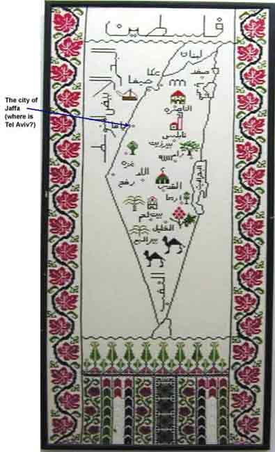
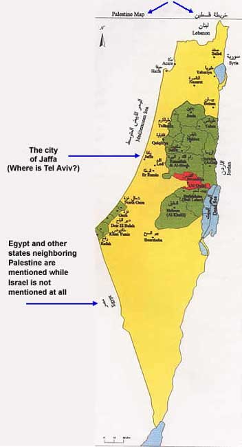
The cities appearing in the area west of the “green
line” omit Jewish-Israeli cities such as Tel Aviv, Ramat Gan,
Rishon Le'Zion, Natanya, Hadera, Holon, Bat Yam, and Eilat. The cities
mentioned in Israeli territory west of the “green line”
are those that up until 1948 were distinctly Arab-Palestinian (namely
Acre, Nazareth, Beit She'an, Lod, Ramla, Jaffa, Beersheba) or cities
that have a mixed Jewish-Arabic population. Especially notable is the
fact that Tel Aviv is not mentioned at all and Jaffa is referenced instead.
These are common characteristics of maps disseminated throughout the
PA areas.
The map appears on page 4 of a book published
by
the PA Central Bureau of Statistics , Ramallah, June 2001
|

“Al-Tarbiyah Al-Wataniyyah”
(“Natioal Education”) 3rd-grade textbook,
2002-2003 academic year, page 3.
|
The Palestinian Flag
The messages regarding the right of the Palestinian
people to all of “Palestine” are disseminated through icons.
To demonstrate the message of “Palestine” as a single Palestinian
entity extending from the Jordan River to the Mediterranean sea, miniature
maps of Palestine adorned with the colors of the Palestinian flag or
bound by it, are circulated throughout the PA areas and beyond.
Following
are some examples.
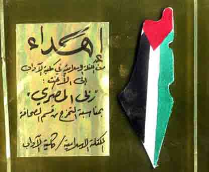
A map of “Palestine”
integrated into the Palestinian flag appearing on a plaque awarded
to the student Raba Al-Masri from A-Najah University in Nablus
by the “Islamic Bloc.”
The plaque was awarded on the occasion of graduation from
the department of journalism in the faculty of Humanities.
|
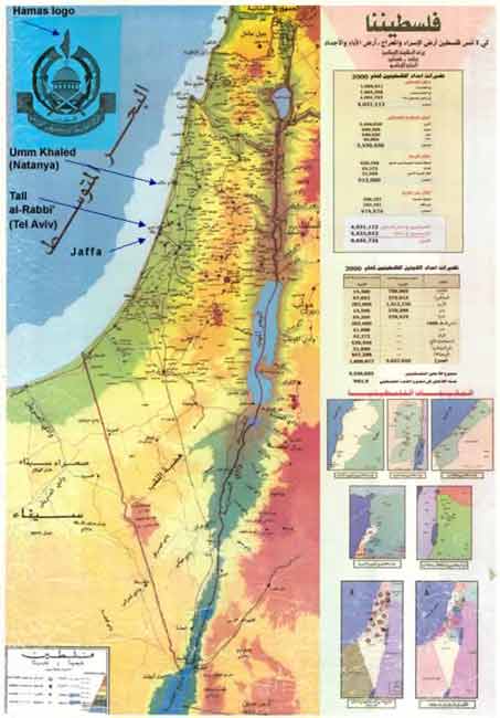
 The flag of “Palestine” next to
a rifle emerging from the word “Hamas” Source: Hamas
magazine “ Filisteen Almuslima ” (currently printed
in Lebanon and circulated from the U.K.), December 1993 issue. The
map was attached to the above magazine to mark the entry to the
seventh anniversary of both the first Intifada and the establishment
of the Hamas.
The flag of “Palestine” next to
a rifle emerging from the word “Hamas” Source: Hamas
magazine “ Filisteen Almuslima ” (currently printed
in Lebanon and circulated from the U.K.), December 1993 issue. The
map was attached to the above magazine to mark the entry to the
seventh anniversary of both the first Intifada and the establishment
of the Hamas. |
The Refugees
Maps of “Palestine” that include names
of Arab villages abandoned during the Israeli-Palestinian conflict,
data concerning Palestinian refugees in the “diaspora,”
and the administrative division of Palestine during the British
mandate period, play a tangible role in inculcating the value of
the “right of return” of Palestinian
refugees, and in intensifying hatred towards Israel.
These maps are published by the PA,
the Hamas Movement, academic
institutions, and entities and associations operating in the PA areas.
Messages instilling the “right of return” are also incorporated
into the curriculum of the PA education system.
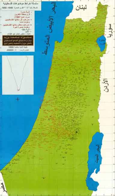
The map was published by
Bir Zeit University - “Palestinian Society Studies and Documentation Center” in cooperation with the PA “Ministry
of Planning and International Cooperation”, 1999; second and revised edition;
scale: 1:300,000
|

A second edition of a map
distributed by the “Arab Studies Society” in Jerusalem, an association belonging to the “Orient House” (the second edition was issued in 1990; the first in 1988).
|
Sources: Intelligence
and Terrorism Information Center at the Center for Special Studies (C.S.S) |