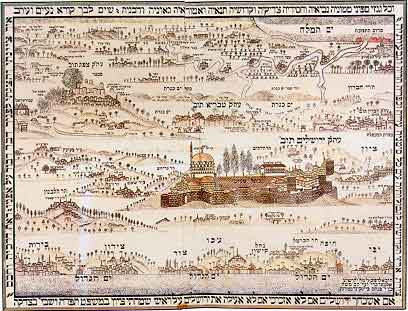
Pictorial Strip Map of the
Land of Israel
(1875)
This illustration by Rabbi Chaim Salomon Pinta of Zefat, in Hebrew and German, represents an original group of maps. Five longitudinal strips show five regions, from Lebanon in the North to Gaza, Hebron and "upturned Sodom" in the South, seen in perspective from West to East. The printing base is unusual, too; the map was produced on cotton cloth. The Holy City of Jerusalem occupies the map center. But although the author was a native of Zefat who knew the country well, the pictoral views of Jerusalem and of the city of his birth are imaginary.
Sources: Israeli
Foreign Ministry
|