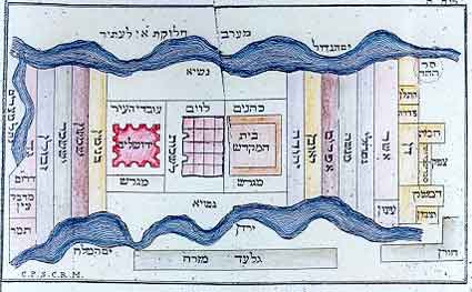
Diagram of the Land of Israel and Jerusalem
(1817)
Already in the early Middle Ages if not before, Rabbinical teachers were called upon to interpret laws related to the Land of Israel, often in letters to Jewish communities in the diaspora. Since they had no access to geographical maps but were aware that graphics are the best means of clarifying territorial relations, they devised diagrams which correctly represented spatial relations described verbally in the Holy Scriptures, disregarding true geometrical location. This cartogram by Jacob Auspitz, though of later date, belongs to this type.
Sources: Israeli
Foreign Ministry
|