“Psalter Map”
(c. 1225)
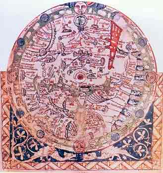
The Psalter Map (named after the book of Psalms) is characteristic of mediaeval world maps, elucidating the writings of the Church fathers rather than geography. Jerusalem is indicated in the center of the map and around it appears, relatively much enlarged, the Holy Land, with the Dead Sea, the rivers Jor and Dan which unite to form the Jordan, as well as Jericho, Caesarea, Akko and other towns.
Sources: Israeli
Foreign Ministry
|