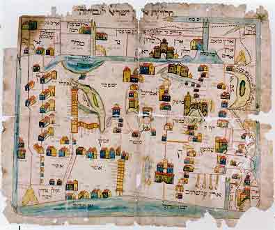
“The Land of Israel,
its Division and Borders”
(1802)
This map is attributed to Rabbi Eliahu ben Shlomo Zalman, known as the Gaon of Vilna. Its original was lost, but the copy displayed here "was copied from the illustrious ... Rabbi Eliahu of the (Lithuanian) capital city Vilna" - as stated below the map title. It was intended to serve chiefly as an instrument of religious instruction. Typical for this clerical approach was the belief that the country was surrounded by water, whether seas or rivers. Jerusalem is represented on the summit of Mount Moriah by a vignette and the acronym B'H'M'K, for the Holy Temple.
Sources: Israeli
Foreign Ministry
|