Archaeology in Israel: Beit She'an
Ancient Beit She'an, located in the Jordan Valley some 30 km. south of Lake Kinneret (Sea of Galilee), was of strategic importance because here the road from Jerusalem northwards met the road from the northern coast eastwards to Transjordan. This strategic position in the fertile Beit She'an valley made it one of the major cities in the Land of Israel.
Introduction
The Earliest Settlements
Egyptian Administration Center
The Canaanite City
The Israelite City
SCYTHOPOLIS
The Hellenistic Period
The Roman Period
The Byzantine Period
Remains from the Roman-Byzantine Periods
Beit She'an-Scythopolis in later periods
Introduction
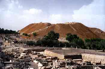
Between 1921 and 1933, major archeological excavations were conducted on the ten acres of Tel Beit She'an (in Arabic: Tel el-Husn - "Hill of the Fortress"). Remains from the Roman-Byzantine period were exposed on the top of the tel (mound) and in its southern part, those of earlier periods: the Bronze and Iron Ages. In the course of the excavations remains of 20 strata/settlements were exposed, which date from the Neolithic/Chalcolithic periods (5th-4th millennia BCE) to the Byzantine period (7th century CE). Excavations on the tel were renewed in 1983, and again between 1989-1996, uncovering more remains of the early cities. From the early 1980s until the present, large-scale excavations have been carried out in the city center of the Hellenistic and Roman-Byzantime periods.
 |
In the Hellenistic period, Beit She'an was renamed Scythopolis (city of the Scythians) and grew, extending southeast to Tel Itztaba. The city reached its maximum size and prosperity during the Roman- Byzantine period, when a new civic center was built in the valley southwest of the tel, surrounded by residential quarters; in the Byzantine period it was also fortified with a city wall.
In the Early Arab period, Beit She'an-Scythopolis declined; it was destroyed by earthquake in 749. A small fortress was built by the Crusaders in the 12th century, to control the crossroads and to guard against Muslim penetration of their kingdom, but the city was never rebuilt. Only a small Arab village existed there in later periods.
The Earliest Settlements
Due to the limited area excavated, little is known about Beit She'an in its earliest periods. However, it is clear from a deposit several meters high, that there was continuous, intensive settlement. The earliest inhabitants, of the Chalcolithic period, lived in caves cut into the rock of the hill. Apsidal dwellings, built of flat clay bricks, appeared at the beginning of the 3rd millennium BCE.
Evidence of a large Bronze Age (3rd millenium BCE) town was exposed. This town extended to the hill east of the tel and its residents lived in multi-roomed broadhouses. One of the buildings was a fine brick structure, roofed with reeds covered by plaster and included a large hall, its walls over one meter thick. This building was either a public storehouse or a granary; it was destroyed by fire, leaving burnt wooden beams and a large quantity of charred grain and pulses. High-quality pottery vessels decorated in black and red were found among local, inferior ware. This led the excavators to surmise that immigrants from northeastern Anatolia and the Caspian region had settled in Beit She'an.
During the Middle Bronze Age (first half of the 2nd millennium BCE), Beit She'an declined into a town of minor significance. In the 16th century BCE, a temple was built of mud bricks covered with smoothed white plaster. It consisted of three parts: an entrance hall, a main hall (heikhal), and an inner room (dvir).
| Chronological Table | ||
| BEIT SHE'AN | ||
| First settlements | Chalcolithic period | 4th millennium BCE |
| Large town | Early Bronze Age | 3rd millennium BCE |
| Small town | Middle Bronze Age | 1st half of 2nd millennium BCE |
| Egyptian Administration Center | Late Bronze Age | 15th - 12th centuries BCE |
| Canaanite city | Iron Age | 12th - 11th centuries BCE |
| Israelite city | Iron Age | 10th century - 732 BCE |
| SCYTHOPOLIS | ||
| Large, wealthy city | Hellenistic Period | 3rd-2ndcenturies BCE |
| Planned city, with civic center | Roman Period | 1st century BCE - 3rd CE |
| Expanded city with wall | Byzantine Period | 4th - 7th centuries |
| City declined, destroyed earthquake (749), small settlement | Early Islamic Period | 7th-10th centuries |
| LATER PERIODS | ||
| Small fortress | Crusader Period | 12th century |
| Village | Late Islamic Period | 13th-19th centuries |
Egyptian Administration Center
During the Late Bronze Age and the beginning of the Iron Age (15th-12th centuries BCE), Beit She'an was an important city and served, as did Megiddo, as a center of Egyptian imperial administration in northern Canaan. The city is frequently mentioned in royal Egyptian documents and inscriptions from the reign of the pharaohs of the New Kingdom. The Egyptian administrative center inside the walled city included a governor's residence, government buildings, a royal granary, and a residential quarter for the families of the Egyptian officials. Egyptian finds, including royal steles, attest to the importance of the city as a center of the Egyptian administration.
Royal buildings in Beit She'an included a succession of temples. These temple complexes combine Canaanite construction with Egyptian architectural elements, typical of the monumental buildings in Egypt proper. The first temple complex in Beit She'an was built during the reign of Thutmose III at the beginning of the 15th century BCE. It consisted of a large courtyard, in part surrounded by halls and rooms in which dozens of Egyptian pottery vessels, brought as ritual offerings, were found. The temple was modified in the 14th century BCE to include a large courtyard with an altar. The temple itself, which consisted of a hall with an altar and an interior room with a small cell behind it, stood at the eastern side of the courtyard. In this temple a stone stele was found, depicting, in Egyptian style, figures standing opposite a seated god, probably the Canaanite god Mekal. The inscription on the stele states that it was dedicated by the Egyptian scribe Pa-re-em-heb to the memory of his father, Mem-ep. Towards the end of the 14th century BCE, a new temple with only a few changes, was built in Beit She'an, and remained in use until the 12th century BCE. It consisted of a large hall with benches for offerings along the walls, its ceiling resting on two wooden columns, which stood on stone bases. Stairs in the rear of the hall led to a long, narrow dvir, 1.5 m. higher than the hall, with a bema against its back wall.
During this period, a fortified governor's residence was built in Beit She'an. This brick building (23 x 22 m.) had thick walls. In its central hall, surrounded on all four sides by rooms, two wooden columns on stone bases supported the ceiling. Nearby, on both sides of a street, were large dwellings for Egyptian officials. Architectural elements, such as door lintels and doorposts, with dedicatory inscription and solemn oaths were found, as well as Egyptian-style luxury items, such as pottery objects and jewellery.
Several basalt steles in royal Egyptian style, dating from the end of the 13th and the beginning of the 12th century BCE, were found in secondary use in Canaanite temples of the 11th century BCE. Two steles from the reign of Pharaoh Seti I include his names and titles. The "Large Stele", the most impressive find from the period of Egyptian rule of Canaan, describes the victory over the Canaanite cities, which had rebelled against Egypt and mentions them by name, including Beit She'an. The "Small Stele" describes the pharaoh's victory over tribes living in the hill region near the city; among them the Apiru (the name of the biblical Hebrews in Egyptian documents). Another stele, from the reign of Pharaoh Ramses II, lists the tof the king and his deeds in defense of the weak.
On a hill north of the tel, the remains of a cemetery from the period of Egyptian rule were uncovered. Dozens of anthropomorphic clay sarcophagi, their lids with naturalistic reliefs of the deceaseds' faces, were found in the graves. The headdresses are similar to those of Philistine warriors depicted in Egyptian temple reliefs from the reign of Ramses III. Scholars assume that Philistine officials or soldiers, who served as mercenaries in the Egyptian garrison at Beit She'an, were buried in these sarcophagi.
Egyptian rule in Beit She'an came to an end in the mid-12th century BCE, when the city was destroyed by fire. The decline of Egyptian control over Canaan caused political unrest, and both the Sea Peoples (to whom the Philistines were related) and the Israelite tribes penetrated the region in this period.
The Canaanite City
The Bible mentions Beit She'an as one of the Canaanite cities which was not conquered by the Israelites under Joshua. (Joshua 17:1 1-12; Judges 1:27) The city is again mentioned after the defeat of the Israelite army of King Saul by the Philistines on Mt. Gilboa (south of the city), when they impaled the bodies of King Saul and his sons on the walls of Beit She'an. (I Samuel 31:10-12)
At the end of the 12th, and during the 11th century BCE, Beit She'an was an important Canaanite city with a mixed population: Canaanites and descendants of Egyptians and Philistines. During this period, a pair of temples was built on the ruins of the earlier Egyptian temple. The southern temple had a long central hall in which two rows of three columns supported the roof, and a number of rooms on both sides. The northern temple was rectangular, and its roof was supported by four columns. The Egyptian stelae, described above, were found here in secondary use. Finds from these Canaanite temples also include several ceramic cultic stands. These tall stands were made in imitation of multi-storied buildings, with plastic anthropormophic and zoomorphic decorations, including snakes and birds. This Canaanite city was burned to the ground at the beginning of the 10th century BCE, probably when conquered by King David.
The Israelite City
Beit She'an is mentioned as an important city in the fifth administrative district of King Solomon. (I Kings 4:12) From this period, administrative buildings, one of them a large structure with numerous rooms that undoubtedly served as the regional administrative center, were uncovered. This city was destroyed to its foundations by Tiglath Pileser III of Assyria, when he conquered the Kingdom of Israel in 732 BCE.
SCYTHOPOLIS
 |
During the Hellenistic, Roman and Byzantine periods, Beit She'an became known as Scythopolis ("City of the Scythians", probably mercenaries who, as veterans, settled there). According to tradition the city was founded by Dionysos, and his nursemaid Nysa was buried there; it was known also as Nysa-Scythopolis.
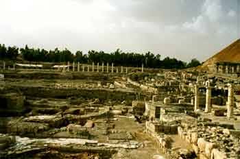
Excavations were carried out mainly in the valley south and southwest of the tel. There, the main streets and public buildings of the urban center of Roman-Byzantine Scythopolis were uncovered and, south of it, the remains of the theater and the amphitheater.
The Hellenistic Period
Beit She'an is mentioned in written sources of the 3rd-2nd centuries BCE describing the conflict between the Ptolemids and the Seleucids (inheritors of the empire of Alexander the Great) over control of the Land of Israel, and with reference to the wars of the Hasmoneans to gain independence from Seleucid rule.
At the beginning of the Hellenistic period, the town was located on top of the tel only. During Seleucid rule (2nd century BCE), it was accorded the status of polis (Greek, city). At this time, the town encompassed tel Iztaba (north of the tel) where remains of a residential area of the period were uncovered. The houses had brick walls on stone foundations, with rooms around a stone-paved courtyard; the walls were covered with frescos and stucco imitating ashlar construction. The remains of a large public building with massive, one meter-thick walls of trimmed stones plastered to look like paneling (stucco), were also exposed.
Scythopolis was conquered and destroyed by the Hasmoneans at the end of the 2nd century BCE. A fierce conflagration left ceramic vessels and other utensils covered in a thick layer of ash. Among the finds were many imported pottery vessels, including dozens of wine amphorae from the Greek islands (especially from Rhodes) with seal impressions on the handles.
The Roman Period
In 63 BCE, the Roman general and triumvir Pompey effectively established Roman rule in Judea, and Scythopolis played a central role in the administration of the area. Granted special privileges, Scytholopis began the count of years from its attaining the status of a Roman polis. It was the largest city of the Decapolis, a league of ten hellinized cities, nine of them east of the Jordan River. Public construction in the new urban center of Scythopolis in the valley southwest of the tel, was begun in the 1st century CE. But very little is known about the buildings of that period, since they were destroyed or incorporated into the massive construction work of the following period.
 |
During the reign of the emperors Hadrian, Antoninus Pius and Marcus Aurelius in the 2nd century (the period of Pax Romana), the empire enjoyed peace, security and economic prosperity, as evidenced in extensive and elaborate construction projects in the Roman cities. Scythopolis was an outstanding example of this high-level urban planning and construction. Impressive, freestanding gateways were built to mark the boundaries of the urban area. In the valley southwest of the tel, a new civic center was created. Along its colonnaded, main streets stood the temple, the basilica, the nymphaeum (fountain) and the bathhouses. To the south of them were the large entertainment complexes: the theater and the amphitheater. The ancient tel now served as the acropolis and the main temple of the city stood there. From Mt. Gilboa, 7 km. southwest of the city, water was carried to the city via aqueduct.
The buildings, as well as the street pavements were of dark basalt stone, characteristic of the region. The public buildings were faced with hard limestone brought from Mt. Gilboa, as were architectural elements, such as columns and carved components. Several buildings were splendidly decorated with granite columns and sculpted elements in imported marble. The public buildings were funded by the Roman administration and by private donors. Inscriptions honoring benefactors of the city, including Roman emperors and governors, were found in the ruins.
Many of the buildings of Scythopolis were damaged in the earthquake of 363. In 409, the city was designated the metropolis (provincial capital) of Palaestina Secunda, which included the Galilee and northern Transjordan. The city's population continued to grow with its administrative and economic importance, and its new status also led to massive repair-work of the damage caused by the earthquake, as well as to restoration and rebuilding.
The Byzantine Period
During this period (4th-7th centuries), the urban center of Scythopolis underwent machanges. The pagan temple in the center of the city was destroyed, yet the nymphaeum and the eastern baths were restored, and a large new bathhouse was built in the south. The basilica was turned into a large agora (square). Some of the streets were improved with mosaic-paved stoas, others were narrowed, with new shops built along them. Many dedicatory inscriptions found in the restored buildings are evidence of the involvement of the provincial administration in these projects; private philanthropists seem to have preferred donating their money for the building of churches and synagogues.
During the 4th and 5th centuries the urban area of Scythopolis grew and spread over the plateau around the civic center. Remains of elaborate villas with colorful mosaics, such as the one known as the House of Leontius, were found in the western part of the city. The population was primarily Christian, as attested to by the large number of churches; but remains of a Jewish and a Samaritan synagogue also attest to established communities of these minorities. During this period, Scythopolis was fortified with a city wall, which incorporated the gateways of the Roman city. The 2.5 m.-thick wall was about 4.5 km. long, with many square towers. It surrounded the entire 400 acres of the city, including the amphitheater and the residential neighborhoods.
In the 6th century, with a population of some 40,000, Scythopolis reached its greatest size and residential areas and churches were also built outside the city wall. Population density, preference for more functional construction and the decline of the imperial and provincial administration led to poor maintenance of the luxurious Roman buildings and to a general deterioration of the city towards the end of the Byzantine period.
Remains from the Roman-Byzantine Periods
Colonnaded Streets
Several colonnaded streets, along which the public buildings of Roman Scythopolis stood, crossed the civic center at the foot of the tel. The width of the streets was about 24 m.; on both sides of the unroofed thoroughfare stood two rows of columns, which supported roofs covering elevated sidewalks lined with shops. The streets were restored in the Byzantine period and mosaic inscriptions with the names of those responsible for the renovation were found (these names were adopted by the excavators as street names, as in the following).
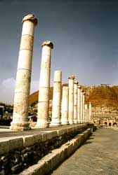 |
Sylvanus Street crossed the city from north to south along the western side of the tel. South of it stood an elaborate, 56 m.-long colonnade, its facade with a row of 7 m.-high columns behind a reflecting pool. Valley Street branched off from Sylvanus Street. This colonnaded street, with 5 m.-high columns, was exposed for a length of 150 m.; it continued for several hundred meters to Nahal Harod, over which a 37 m.-long stone bridge was built, supported by three massive piers from which sprung two great arches. At the northern end of the street was a monumental gateway with a 7 m.-wide opening and a vaulted roof. It served those entering the city from the north, along Valley Street to the city's center. The gate was incorporated into the city wall in the Byzantine period.
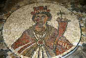
Palladius Street, another colonnaded street, extended from the theater northward for 150 m. to Sylvanus Street, at the foot of the tel. The western colonnade of the street was re-paved in the 4th century, according to a mosaic inscription, during the governorship of Palladius son of Porfirius. At the center of this colonnade was the Sigma Plaza (a semi-circular plaza in the form of the Greek letter sigma), which according to a mosaic inscription, was built in the beginning of the 6th century. It served as a center for entertainment, as well as for commerce. Sigma Plaza was paved with stone slabs and the 12 rooms around it with colorful mosaics patterns. The floor of one room had a round frame with a portrait of Tyche, the patron goddess of Scythopolis. The crown on her head is in the form of a city wall with towers, and in her hands she holds a cornucopia filled with fruit and a palm tree.
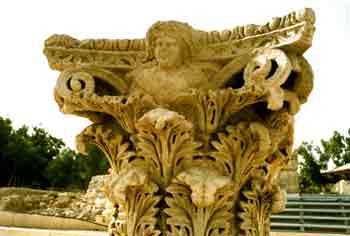
The intersection of the colonnaded streets of the civic center of Roman Scythopolis, near the southwestern corner of the tel, was marked by a great, 15 m.-high monument. It consisted of a trapezoidal platform (ca. 14 x 12 m.) on which columns with Corinthian capitals supported arches and a decorated frieze.
The Acropolis
At the northern end of Palladius Street, at the foot of the tel, stood a monumental propyleum (gate structure) with three entrances. From it a staircase, the via sacra, (sacral way) led to the top of the tel, which was the acropolis of Scythopolis. An altar, with dedications to Zeus Akraios (Zeus of the Heights - the acropolis) was found at the foot of the tel, indicating that a temple to Zeus, overlooking the city, had once stood atop it. During the Byzantine period, the temple was removed and a church built in its place.
The Basilica
The central civil basilica of Scythopolis, 70 m. long and 30 m. wide, was located west of the intersection of the main streets. Rows of columns with Ionic capitals created roofed aisles on four sides of an open courtyard. The basilica served as the commercial center of the city and legal and public affairs were also conducted there.
A large agora (square) replaced the Basilica during the Byzantine period. As it was located between existing Roman buildings, its shape was irregular; it was completely enclosed by colonnades. The agora played a central role in the commercial life of Byzantine Scythopolis.
The Nymphaeum
This public fountain, located on Sylvanus Street next to the monument, was a very elaborate building with a semi-circular facade - an apse facing the street, with niches for statues. On podiums flanking the structure stood two pairs of large fluted columns. Water from the aqueduct was fed into the back of the nymphaeum, and piped through openings in its facade into a small pool.
The Temple
A Roman temple stood at the intersection of Sylvanus and Palladius streets, probably dedicated to the cult of Dionysus, the traditional patron god and founder of the city. It apparently also served the cult of Nysa, the nursemaid of Dionysius, who was also regarded as a goddess. The temple was built on a 20m-high podium supported on a series of arches. Its was reached by a wide staircase from the plaza. In the facade was a pronaos (front hall) with four enormous limestone columns on bases, each weighing 25 tons. These columns supported a decorated gable. A pedestal found in the plaza in front of the temple bears an inscription in Greek with the name of Emperor Marcus Aurelius (l6l - l80) which begins: With good fortune. The residents of the city of Nysa Scythopolis... The temple was largely destroyed by the Christians in the 4th century, but its beautiful facade remained standing.
The Eastern Bathhouse
Located on Sylvanus Street east of the Basilica, it included a square hall (20 x 20 m.) that served as the frigidarium (cold room) of the bathhouse. The room's wall and floor were covered with marble slabs. In one of its walls was a fountain and in the other walls were niches for statues. Fragments of statues, probably smashed in the Byzantine period, were found in a pit below the bathhouse; they are those of a life-sized young Dionysus, a nude Aphrodite, an emperor wearing armor and an Athena.
The main part of the bathhouse contained rooms and halls, including a caldarium heated by a hypocaust. A large latrine, with a colonnaded courtyard, had rows of evenly spaced stone toilet seats along its walls, and drainage channels beneath them.
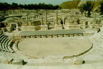
The Theater
The monumental theater of Scythopolis stands at the southern end of Palladius Street and is the best preserved building from Roman times. Performances consisted mainly of light entertainment such as acrobatics, impersonations and sports competitions, though plays were also presented.
The theater, 110 m. in diameter, was built on a hillside, its rear wall partly cut into bedrock. Its facade towards the tel, where the Temple of Zeus stood, was surrounded by plazas. The theater had 7,000 seats made of limestone, in three blocks. Only thelower tier of seats, consisting of 13 rows including the lowest one reserved for dignitaries, remained complete. There were nine radial staircases, but only the core of the middle block remained, as the limestone seats had been removed at a later time. A row of large pilasters around the outside of the structure indicates that there existed an upper block of seating, of which nothing remains today. Eight arched passageways led the spectators into the theater. The semicircular orchestra area was paved with marble; it was reached via arched passageways that ran under the blocks of seating. The raised stage, also paved in marble was built on a row of arches. The scenae frons, the architectural backdrop to the stage, was 21 m. high. The side facing the seats consisted of niches that held statues, and a row of alternating black and red granite columns supporting decorated friezes. Along a corridor, behind the scenae frons, were cubicles for the use of the performers and stagehands. Three openings in the northern wall of this corridor provided direct access from Palladius Street.
The Amphitheater
 |
The amphitheater was located on the plateau south of the Roman civic center. A hippodrome had been built here, of which very little is known, since the Roman amphitheater was built on its western part. The oval amphitheater (102 x 67 m.) encloses an arena 82 m. long and 47 m. wide. The arena was surrounded by a 3.2 m.-high wall, with 10-12 rows of seats, for 5,000-7,000 spectators. Only three rows of seats were preserved. At the center of the seating-block on the north side was a platform for dignitaries, an orchestra and the game organizers. On the western and eastern sides of this wall were openings for direct access to the arena; several rooms along the wall around the arena may have been cages for wild animals. Performances at the amphitheater probably included contests between gladiators, hunting of wild animals, sport competitions and more.
With Byzantine-Christian rule in the 4th century, performances in the amphitheater were forbidden. In the following centuries, dwellings, as well as industrial and commercial structures, were built on its remains and a basalt-paved street linked this suburb to the center of town. Two Greek inscriptions state that the paving was the generous gift of the Archon (title of the provincial governor) Flavius Orestes (535).
The Western Bathhouse
Northwest of the theater, at the southern end of Palladius Street, a large bathhouse complex, 100 m. long and 90 m. wide, was constructed in the 4th century. A monumental propyleum (gateway), with columns and carved friezes connected the street to a mosaic-paved colonnade, which led to the bathhouse courtyard. The courtyard was surrounded, on three sides, by broad porticos paved with mosaic or colored marble tiles. The mosaics, according to an inscription, were replaced in 535 with marble pavement. The bathhouse itself consisted of eight halls with an open pool and fountains in front of it. At its center were large halls heated by hypocaust. Stone domes covered the halls, the floors were paved with marble slabs and the walls were decorated with paintings. The building also included two public latrines. The many inscriptions engraved in stone or incorporated in the mosaic pavements indicate renovations and changes made by the provincial governors. An outstanding addition in the 6th century was an apse built in the western portico of the courtyard; it served for public gatherings.
A Synagogue in the House of Leontius
 |
The House of Leontius, so named by the excavators (1964-72), was built in the Byzantine period in the western part of Scythopolis. In the excavations, only several rooms around a courtyard were exposed, including one on the southern side (7 x 7 m.), which had served as a synagogue. Its colorful mosaic floor had an outer belt decorated with flowers and birds, around medallions with animals, created by vine trellises emerging from an amphora. The central medallion enclosed a menorah (candelabrum) beneath the word shalom (peace). Four inscriptions were found in the room: one of the two in Aramaic mentions members of the holy community who contributed to the renovation of the building; one of the two Greek inscriptions refers to Jose the innkeeper, lending credence to the idea that the synagogue was part of an inn.
Several rooms were located on the northwestern side of the building, one of them with a beautiful mosaic floor featuring scenes from the Odyssey: Odysseus bound to the mast of his ship; and struggling to resist the lure of the Sirens. A Greek inscription refers to Leontius and his brother Jonathan, who donated the mosaic floor and wished to be remembered for their deed.
The Monastery of the Lady Mary
The Monastery, founded in 567, is located at tel Itztaba; it was excavated in the 1930s. This building, near the inner side of the city wall of Scythopolis, was named after a donor mentioned in one of the dedicatory inscriptions. The monastery included a church, and many rooms with mosaic floors. The mosaic floor of the central hall of the church has frames of different shapes and sizes in which animals, such as lions, camels, boars and ostriches are depicted. At its center is a zodiac with the Greek names of the twelve months.
The Samaritan Synagogue
This synagogue was also located at tel Itztaba, outside the northern part of the Byzantine city wall of Scythopolis. The building was excavated in 1960. Its plan was basilical, with an apse oriented northwest, not towards Jerusalem. The mosaic floor had floral and geometrical motifs, but no human or animal images. The square carpet in front of the apse depicts an aedicule (shrine) supported by columns and covered with a parochet (curtain). On both sides of the aedicule are identical presentations of cultic symbols: menorah (candelabrum), shofar (ram's horn) and incense shovel. One of the inscriptions in the mosaic floor is in Greek, but written in Samaritan script, which led to the surmise that the building was a Samaritan synagogue.
Beit She'an - Scythopolis in later periods
Scythopolis came under Muslim control in 635 and was renamed Beisan. The city was not damaged and its Christian population lived together with the newly arrived Muslims until the 8th century, but during this period the city declined and its Roman-Byzantine architectural glory was lost to neglect. New structures were erected in the streets themselves, narrowing them to mere alleyways, and makeshift shops were opened in the colonnades. By the 8th century, the city had reached a low point; marble was removed for making lime, Palladius Street was blocked and Sigma Square was turned into a cemetery.
On l8 January 749, the town now known as Beisan, was completely destroyed by an earthquake, as documented in Jewish literary sources. Large quantities of pottery, metal and glass vessels, and jewellery, as well as gold and silver coins and a number of skeletons were found in the excavations.
In the l2th century, the Crusaders built a small fortress south of the tel, using stones removed from the buildings of ancient Scythopolis. After their defeat at the end of the century, Beisan became an Arab village, bearing no resemblance whatsoever to the monumental and elegant city it had once been.
Preservation and restoration of the remains of the civic center of Roman-Byzantine Scythopolis was undertaken in conjunction with the archeological excavations. It is again possible to walk along the colonnaded streets of the civic center, to admire the public buildings and to visit the theater, which has been partially restored and in which performances are once again presented.
The theater was excavated in the 1950s by S. Appelbaum. Excavations at Tel Beit She'an in 1983 were directed by Y. Yadin and S. Geva; those conducted from 1989 to 1996 were under the direction of A. Mazar on behalf of the Hebrew University of Jerusalem.
Source: Israeli Foreign Ministry.
Photos courtesy of Jack Hazut.
Download our mobile app for on-the-go access to the Jewish Virtual Library